4DMapper Launches Complete Geospatial Data Solution
4DMapper, a browser-based 3D geospatial data gateway, has been launched this week, changing the way geospatial data is stored, delivered, visualised and shared. Powerful cloud processing enables the fusion of multi-source content and seamless streaming of massive data files, immediately, to unlimited users on their browsers. According to 4DMapper, this turns the geospatial world inside out, enabling access to big data without local storage, hardware and software.
Geospatial datasets are massive and growing: from Lidar, satellite imagery, photogrammetry (orthophotos, digital terrain models and point clouds) to laser scanner point clouds. Current management solutions involve shipping of hard drives, blind ftp transfers or uploading and downloading via traditional GIS web servers. Then, on delivery, relying on high-end computing resources, large local storage, expensive software and experienced personnel to access the data and visualise it in 3D.
Cloud computing
4DMapper harnesses the power of cloud computing to enable immediate viewing and management of numerous massive datasets in rich real 3D. This changes the current way of storing, delivering, accessing and managing geospatial data. 4DMapper combines secure cloud based spatial data storage, robust management, processing, sharing, 3D/4D visualising and publishing, all in one place, on a browser. No heavy storage requirements, no expensive hardware and no software to install, licence and learn.
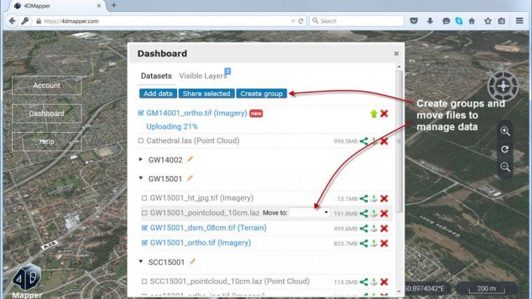
Any Geospatial data, including imagery, 3D digital terrain models and point clouds, can be uploaded and processed for streaming. 4DMapper has made the ingestion of large volumes of geospatial data easy for data providers by simply dragging and dropping it into a browser. Any external data from standard GIS web map service (WMS) can also be combined into a project.
Unlimited
Users can group data for visual access and delivery. By sending a URL, unlimited multiple recipients have immediate access to this data, on their browsers. Recipients don't have to wait do download every GB or TB of data before they can view it. They don't need any local storage, powerful computer resources or specialised software. They have immediate full access to the data source, if granted permission, to download, analyse and store it back on the cloud.
Brilliant, powerful geospatial data is now available to non-GIS experts such as executives, general managers, clients, stakeholders, sales and marketing colleagues, government bodies and the general public. Embed a live project in your website, blog or forum. Send a URL to anyone to experience the project, immediately, to its full high resolution, with just a browser.
Value
Data owners, providers and distributors, service companies, government organisations, anyone with geospatial data can share their data and collaborate with others, across their industry, whether agricultural, mining, environmental, hazard management, infrastructure, telecommunications or any other industry using geospatial data.
4DMapper is designed to add value to existing geospatial software, products and services. It extends the reach of existing products to non-GIS specialists and reduces the costs, in time and money, of local storage, control, management, sharing, access, delivery and visualisation of spatial and temporal (4D) data.
More details are available at web.4dmapper.com.

Value staying current with geomatics?
Stay on the map with our expertly curated newsletters.
We provide educational insights, industry updates, and inspiring stories to help you learn, grow, and reach your full potential in your field. Don't miss out - subscribe today and ensure you're always informed, educated, and inspired.
Choose your newsletter(s)


