Cadastre Modernisation
Libya’s New Land Administration System
Libya has recently completed one of the biggest cadastre projects ever. A fully automated workflow has been established through all departments across the Land Registry Authority, supporting new working practices and improving land administration services. The author describes the new system, implemented with the assistance of Esri Northeast Africa consortium.
Like many other countries around the world, Libya needs sustainable land management to deal, among other issues, with the environmental. Proper land management requires land-use and land-ownership services based on up-to-date, reliable and detailed information which is rapidly and easily accessible. Land administration systems (LAS) in many countries have not yet reached the stage of advancement entailed. Fortunately, many countries also admit that their LAS needs to undergo modernisation in order to enable sharing of information on land ownership and land use across all government departments and agencies . This in support of development strategies, policies and mechanisms for sustainable land use, assessment of the state of economy and collection of property tax.
Design Philosophy
To improve land administration processes in Libya the existing manual and distributed workflows had to be replaced by an automated solution that is cost-efficient, reliable and scalable, and which integrates Land Registry and Cadastre within one LAS. The solution should protect the sovereignty of government land ownership through accurately recording land ownership. Opportunities for corruption should be prevented and disputes over ownership reduced. An archiving system has been introduced to digitally store the workflow, associated forms and documents.
The new system should also be friendlier towards indigenous and foreign investors. Furthermore, the office environment for both staff and customers should be improved over the existing situation and processes servicing external users simplified.
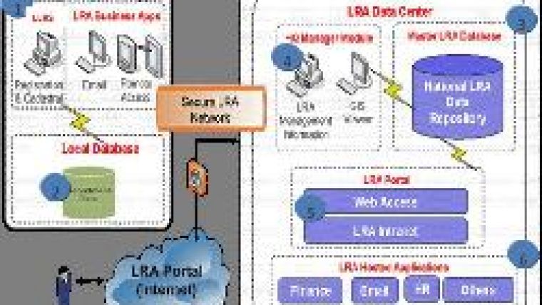
Architecture
The solution chosen includes software, hardware and network, representing a state-of-the-art scalable infrastructure guaranteeing high performance. To avoid spending time on building applications from scratch, the system is assembled from commercial off-the-shelf systems either available in Arabic or easily customisable in the language. The open architecture can be flexibly integrated with any legacy or future systems. The Cadastral and Land Registration tables are integrated in one national LRA data repository hosted in a relational database (Figure 1). The unified data model supports current and future requirements without sacrificing data integrity. At the 45 LRA departments distributed across the country, local databases will be installed containing departmental data. The national repository will be accessible through a secure network, providing a single ‘point of entry' for the management of all land and property transactions. To support department employees using the new registration workflows, which may seem complicated at first, wizards have been created to guide them through their tasks in a logical and intuitive manner.
Broad Access
Not only LRA users are being served, but also public and private entities. Based on LRA regulations, external users get access to specific datasets via an internet-based portal. These users benefit from query and search features which improve tracking requests and facilitate document extraction and submission. Reports are generated with Crystal Reports for .Net technology, which directly accesses the database. Accurate performance statistics, created by the system, give LRA managers better insight into the day-to-day operations. Establishing access rights and verifying authorisation are carried out with the help of Active Directory: a central component of the Windows platform which is also used to enforce staff assignment policies. Measurements collected in the field with survey instruments can be easily downloaded into a geo-database to update changes in property boundaries, leading to efficient management of parcels (Figure 2).
The system also allows the creation of sample parcel reports (Figure 3). Sharing maps, geo-databases and tools across LRA and with external users is enabled through hosting them on an ArcGIS Server. The main advantages of this approach are central management of data, multiple user support, and up-to-date information dissemination.
Digitisation and Capacity
A critical part of the implementation procedure is completion and digitisation of registry maps covering all 45 departments in Libya. So far the registry maps for seven departments have been finalised and the system has gone on air in these. Maps for the remaining departments are currently undergoing finalisation. About 70% of the maps have been completed; the full 100% will be reached by 2011, an estimate based on extrapolating present progress. The modernisation of internal processes and public services also requires strengthening of institutional and human resources capacities and knowledge transfer.
To build capacity, the implementation of the system has been coupled with a comprehensive training programme. Sufficient capacity has been created to ensure that LRA staff can manage and expand the system without the need for external assistance. The new system also facilitates the development of a more customer focused attitude among LRA staff.
Concluding Remarks
Libya's new LAS improves operation of the cadastre and land registration throughout 45 LRA departments distributed across the country according to defined business rules. The benefits of Libya's new LAS to government, the public and the private sector will be felt in many ways and for many years to come.

Value staying current with geomatics?
Stay on the map with our expertly curated newsletters.
We provide educational insights, industry updates, and inspiring stories to help you learn, grow, and reach your full potential in your field. Don't miss out - subscribe today and ensure you're always informed, educated, and inspired.
Choose your newsletter(s)


