Creative Thinking Helps Image Providers Grow Their Business
Visual Intelligence
Visual Intelligence LP is an industry-leading software and sensor technology company that delivers world-class geoimaging solutions for airborne, terrestrial and mobile applications. The company provides innovative technology solutions, including the iOne modular and scalable family of oblique/3D and engineering mapping multipurpose geoimaging sensors which includes automated 2D/3D software workflows for high-speed, actionable information-product generation. Visual Intelligence is known for its industry innovations and patents, and is proud to hold USGS Digital Aerial Sensor Type Certification and the 2013 Geospatial Forum World Technology Innovation in Sensors Award.
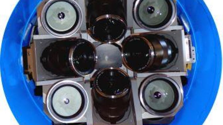
| The iOne reconfigurable sensor array configured as oblique system. This array design has widespread uses and applications beyond arial imagefy. |
Founded in Houston, Texas, USA, Visual Intelligence LP is a privately held company that was started in 2003. The company’s founders began with the idea that their user-centric approach to a traditional industry would result in a new and non-traditional solution. They set forth to rethink the way aerial sensors are built, and ultimately designed and patented a sensor system like no other, using an architecture and array that lets the user reconfigure, expand and change the size and type of image that is captured. Visual Intelligence developed this new approach to give the user more options, provide a high-quality product at a reasonable price, and give customers a flexible and stable growth path for the future.
Innovative Solutions
The Visual Intelligence team is a highly skilled engineering group devoted to providing superior imaging technology. Their customer-centric focus is fundamental to the Visual Intelligence sensor solution, building products that are in production use today and are also an essential platform for image providers to use as they grow and expand. The use of the technology expands beyond standard aerial image collection to influence the development of innovative imaging products in a variety of industries.
President and CEO, Armando Guevara, says: “At Visual Intelligence we have the vision to incubate a lot of new ideas and provide products that have a lifespan that supports our customers’ future needs. We provide world-class digital aerial imaging technology solutions and at the same time we raise the bar and strive to become even better.”
The framework of the sensor systems allows the product development team to quickly create innovative solutions that keep pace with new opportunities. Executive Vice President Phil Kern states, “Our flexible solution suite allows Visual Intelligence to respond rapidly to the constantly evolving needs of our clients, and be ready when new requirements and business opportunities affect the geospatial marketplace.”
The foundational array design in the Visual Intelligence sensor solution provides the platform for multiple cameras to be used in various configurations. The solution uses high-end machine vision cameras that deliver a frame rate of 1 frame per second, have extreme precision of less than two pixels absolute accuracy, and are field-proven to be reliable with no internal moving parts or shutters to break down. The sensors are coupled to the array architecture housing, and users can expand the image footprint by adding additional cameras to the array.
| Imagery captured after a hurricane with the iOne sensor system. |
Competitive Edge
Being able to accelerate jobs and bid on new project types improves the ROI for image providers when they purchase a cost-effective flexible solution instead of a single-purpose camera. Adding the ability to collect a range of image sizes from 108 to 238 megapixels, configure oblique sensors for 3D imagery, or co-register and co-mount various sensor types for image fusion projects with Lidar and other sensor types expands the possibilities even further. By taking advantage of the lightweight sensor options, image providers can look at new ways to save money using lighter-weight and more versatile single-engine planes or expand their offerings to UAV/UAS collection if necessary.
| Image fusion combines targeted data to provide detailed insight into specific project needs (image courtesy of McKim & Creed) |
New Opportunities
Visual Intelligence’s insight into the industry uniquely positions its customers to take advantage of new business opportunities as they arise – for example, the fast-growing demand for highly accurate 3D imagery. Because customers who have the iOne sensor suite can potentially use it for orthophotos and oblique/3D mapping projects, they already have a sensor system in place to accept these new business opportunities without incurring high front-end costs. The company’s iOne SRK (Sensor Reconfiguration Kit) allows for reconfiguration of sensors to meet mission-specific requirements. In 2014, the iOne claimed both the Technology Innovation award and the overall Grand Award in the Geospatial Product and Services Excellence competition sponsored by the MAPPS Association.
Visual Intelligence customers can expand or possibly use their existing system to capture imagery with extremely high 0.6 base to height (b/h) ratio, giving them the ability to provide precise 3D oblique imagery with extreme vertical accuracy.
Combining different data types into a single next-generation geospatial data product using ‘image fusion’ gives customers more image detail and information than ever before. The Visual Intelligence sensor system’s patented technology allows users to co-mount and co-register cameras and other types of sensors such as Lidar, video or thermal sensors in order to co-register and fuse different types of imagery collected in a single pass. When the images are collected, the data is merged together to provide valuable geospatial products that can be used to make informed decisions.
The ability to add more precise and better-quality data to aerial imagery opens up business opportunities with professionals such as property specialists, engineers, planners, transportation managers and utility providers who now depend on these geospatial data products to make informed decisions when planning or implementing new projects. This new demand brings fresh opportunities to the image providers who are prepared and ready to capture this new business.
Image providers no longer have to buy a single-purpose sensor for one project type and rely on it for other projects that may not be a good fit. Instead they can field-configure their Visual Intelligence sensor solution for a variety of different mission requirements, allowing even small providers to bid for more projects and generate new revenue streams.

Value staying current with geomatics?
Stay on the map with our expertly curated newsletters.
We provide educational insights, industry updates, and inspiring stories to help you learn, grow, and reach your full potential in your field. Don't miss out - subscribe today and ensure you're always informed, educated, and inspired.
Choose your newsletter(s)


