Esri Supports White House Police Data Initiative
Esri has announced the availability of the ArcGIS Open Data Initiative for Law Enforcement, which allows police agencies of any size to build and share authoritative data for better policing and community engagement. The Esri announcement supports the White House Police Data Initiative, which has mobilised 30 leading jurisdictions across the USA to take action on recommendations in the area of data and technology. These key jurisdictional stakeholders are establishing a law enforcement community that facilitates knowledge sharing, community-sourced problem solving and the establishment of documented best practices for police departments nationwide.
Esri wants to make it easy for law enforcement agencies to participate in the White House Police Data Initiative, said John Beck, law enforcement industry manager at the company. Using the ArcGIS platform, you can use data your agency already owns and make it available to everyone at no cost and increase transparency in your community, he added.
Public trust
Esri ArcGIS software helps agencies by providing a location platform that uses maps and map-based information to improve public trust and police legitimacy. For decades, law enforcement agencies and local, state, and federal government entities have used ArcGIS software and data for a host of citizen services.
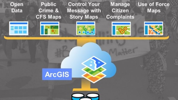
Law enforcement agencies can now take advantage of ArcGIS Open Data Initiative for Law Enforcement to get the most out of their authoritative location data. They can quickly configure and deploy maps and apps for public consumption, including the following:
- Public open data portals
- Apps for mapping crime and calls for service
- Apps for mapping the use of force and officer-involved shootings
- Apps for reporting and managing citizen complaints
- Maps of major investigations
- Maps of community outreach events
- Maps of crime patterns and trends
Law enforcement agencies can easily make their data available to all stakeholders:
- Community leaders
- The press
- Researchers
- The public
Esri will continue to support open data for law enforcement by collaborating with leading law enforcement agencies to create custom applications that intuitively meet a host of needs, from investigations to corrections, crime analysis, operations, and more. To learn more about how ArcGIS improves law enforcement, see here.

Value staying current with geomatics?
Stay on the map with our expertly curated newsletters.
We provide educational insights, industry updates, and inspiring stories to help you learn, grow, and reach your full potential in your field. Don't miss out - subscribe today and ensure you're always informed, educated, and inspired.
Choose your newsletter(s)


