Expanding Aerial Mapping Services with a Phase One Camera and Lidar
Established in 2007, Birdview is an Italian aerial data acquisition company that specialises in power line inspection. Its main office is in the north of Italy, where it operates with nine employees providing services to Italian and international utility providers. The missions are typically flown with helicopters and help utility companies to control and maintain their power and pipeline networks and carry out annual quality control checks. In response to client requests for higher-accuracy survey data for quality control purposes, Birdview has recently extended its sensor range by adding a Lidar (RIEGL VUX 1) and a Phase One iXA 160 camera.
To suit different projects, Birdview employs a variety of sensors; from small FLIR cameras, to Corona and Wescam sensors in gimbal mounts. As technology changed, Birdview’s clients requested higher accuracy survey data for the quality control of their existing and newly built powerlines and pipelines. In 2013, Birdview grew their sensor range by adding a Lidar (RIEGL VUX 1) and a Phase One iXA 160 camera. The use of a Lidar system in combination with a Phase One iXA 160 enabled Birdview to expand their services by adding a sensor solution for high-accuracy surveys.
Birdview’s clients need very high resolution images, which can only be obtained from low altitude flights with low air speed using manned helicopters. The high resolution is needed to capture the minute details of the wires, conductors, poles and the changing swing (changes based on temperature) of the wire in different temperature ranges over the year. The swing of single wires is especially important to analyse, as this enables utility companies to determine when a cable changes from elastic to static and therefore needs to be replaced. An early replacement can avoid black outs or damage. To obtain this precise information, the combination of Lidar and still imagery is the most efficient way to get the job done.
Benefits
The decision to use the Phase One iXA camera was based on Birdview’s intensive research. They found that the camera is easily integrated with the RIEGL Lidar VUX 1 and that the opening angle of the Phase One iXA, using a Rodenstock 40 mm lens, is almost identical to the Lidar field of view. For Birdview, the iXA 160, built with a 60 MP sensor, offers an image with just the right amount of resolution for their needs. The Phase One camera, with the Rodenstock lenses, provides the detailed information that is needed, while at the same time generates a manageable amount of data, without slowing down the workflow. They found the iXA 160 to be a perfect match for their client’s needs and fit in well with the systems that Birdview already had in place.
Another important consideration that Birdview took into account was the size and weight of the camera. They needed to minimise the payload of the complete pod and they found that the Phase One camera was a good fit. The light weight was an important consideration in keeping the payload weight down as the pod needs to be attached to the outside of the helicopter and an STC is required for this. The lower the payload weight, the easier it is to establish a solid connection between the pod and the helicopter.
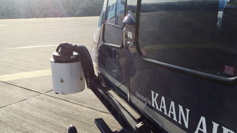
Camera integration
Birdview found that the integration was made even easier when they learned that the camera can be controlled from the RIEGL RiACQUIRE software, which also controls the Lidar, eliminating the need for another control software to run in the aircraft at the same time.
The integration of the camera inside the pod, together with the Lidar, was done in house. They designed the pod and all the necessary connections to the helicopter.
The pod, which holds the Lidar, Phase One camera and IMU/GNSS system can easily be swapped between different helicopters on a moment’s notice. This is especially useful, because Birdview takes on projects outside of Italy and rents aircraft for the purpose. They can pack up their system and attach it to a rented aircraft, perform the project and return to Italy for the processing.
Projects
The typical projects where Birdview uses their Lidar system, combined with their Phase One camera, are operated from an altitude of approximately 150 to 200 meters above the top of the power lines. From this height, the Lidar has a beam footprint of approximately 75 to 100 mm and the iXA 160 offers a resolution of three to four cm (GSD). This combination is a perfect match for the orthophoto, which is generated later.
When flying at low altitudes, the speed of the helicopter needs to be slow in order to make sure that the Lidar system can generate the needed number of points per square meter. Even at this low speed, the camera operates at a fast and constant burst rate and takes pictures in less than two seconds per frame. This fast and consistent capture rate was an important factor for Birdview in choosing the Phase One iXA 160. Standard Birdview projects entail capturing approximately 2,000 to 3,000 images a day. In one of their latest projects, Birdview operated for 15 days and shot over 10,000 images during the mission. The reliability of the Phase One iXA camera made this project a success and the camera worked flawlessly over the complete project.
Alessio Mugnaioli, managing director of Birdview, said the colours of the images they get from the Phase One iXA camera are outstanding. The images are sharp and clear, but it is especially the colour quality that makes this camera a perfect tool for the projects Birdview carries out. What makes it so impressive is the fact that the camera can capture this quality even under bad weather conditions. This is important as they have to fly long power lines in a short amount of time, especially in places like the Alps, where the weather can change quickly. This helps to get the job done and produce the highest quality orthophotos for the customers.
Post-Processing of Data
In the post processing stage, Birdview uses the RIEGL RiPROCESS software for the Lidar data and the software package from TerraSolid for the orthophoto and true orthophoto production. Their standard deliverables for utility customers are point clouds, shape files, true orthophotos, elevation models and 3D models of the powerlines and pipelines. The images from the Phase One camera are used to produce orthophotos. DTMs, DSMs. and other 3D data is based on the Lidar data itself. But in today’s business environment, Lidar data is not enough to serve the needs of the end users. Clients often request images for projects, which indicates the popularity of Lidar missions using cameras to capture the image data for orthophoto production. Birdview has found that on their large powerline/pipeline projects, they achieve on average, an accuracy of about 10 cm, which answers the specific needs of their clients.
Markets
Birdview has become well-known in Italy and has gained a reputation as a provider of accurate and dependable deliverables to their clients. Word spread quickly outside of Italy, and Birdview started receiving requests to move into other countries to perform projects for utility operators. Today, Birdview serves customers in the European Union and in Turkey and is in discussion with a number of African utility operators. Alessio Mugnaioli stated the combination of the RIEGL Lidar and the Phase One camera opened up new markets and helped to grow Birdview’s business over the last years faster than any time before that.

Value staying current with geomatics?
Stay on the map with our expertly curated newsletters.
We provide educational insights, industry updates, and inspiring stories to help you learn, grow, and reach your full potential in your field. Don't miss out - subscribe today and ensure you're always informed, educated, and inspired.
Choose your newsletter(s)


