Joint UAS Lidar Solution for Multiple Applications
In the exhibit hall at the recent International LiDAR Mapping Forum (ILMF) in Denver, Colorado, USA, Juniper Unmanned, Pulse Aerospace and YellowScan collaborated to showcase Lidar data acquisition capabilities from an unmanned aerial system (UAS). This collaboration highlights Juniper’s ability to engineer UAS solutions with hardware offerings from Pulse and YellowScan. As a result, the co-located exhibit booths were visited by interested conference attendees seeking to learn more about this technical solution.
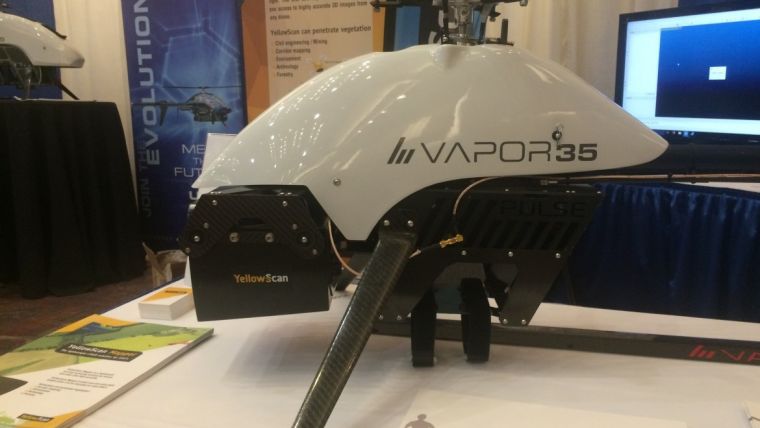
Acting as the solution developer, Juniper facilitated the integration of YellowScan’s Mapper sensor onboard the Pulse Vapor 35 UAS. The purpose of this partnership was to feature the high-quality and affordability of the YellowScan Lidar scanner paired with the flight stability and duration of Pulse’s unmanned helicopter platform.
Applications
Going forward, this mapping solution will support a wide variety of commercial applications for UAS service providers in the mining, agriculture, power delivery and civil infrastructure markets. As a result, airborne Lidar data acquisition will become more affordable, more frequent, and more accessible for a large portion of the surveying and mapping community.
After a decade of research and development, Pulse Aerospace is ushering in a new age of vertical takeoff and landing (VTOL) helicopter UAS platforms.
Pulse's VAPOR 35 delivers up to one hour of flight time on a single battery charge and enhanced flight stability. To accomplish these characteristics, Pulse pairs their aircraft with its advanced flight control system to provide energy-efficient flight operations that eliminate human error.
YellowScan
YellowScan designs, develops and produces drone sensor systems for commercial applications. The company’s Lidar sensors are fully integrated, ultra-light and easy to use, allowing for simplified flight operations supporting automated data collection activities. YellowScan’s turnkey sensor solutions include a tightly coupled hardware integration of GPS, IMU, Lidar scanner, power source, data storage and an onboard computer. The benefit of this turnkey sensor approach is that users can immediately see the results of their data collection activities in the field, which allows them to make business decisions more rapidly.
To learn more about Juniper’s flight services offering, please email Jeff Southard.

Value staying current with geomatics?
Stay on the map with our expertly curated newsletters.
We provide educational insights, industry updates, and inspiring stories to help you learn, grow, and reach your full potential in your field. Don't miss out - subscribe today and ensure you're always informed, educated, and inspired.
Choose your newsletter(s)


