Mapping Using Polarimetric Radar Imaging
Metasensing
Synthetic Aperture Radar (SAR) is becoming more and more requested in the commercial and scientific world, especially considering the latest developments toward compact, high-resolution and cost-effective sensors. Since 2008, MetaSensing has been commercially offering services and sensors allowing a larger group of users to benefit from the advantages of SAR technology.
What is SAR? Synthetic Aperture Radar is a remote sensing imaging technology. Like Lidar, radar is an active sensor that transmits electromagnetic energy and records the reflection of this energy from objects on the Earth's surface. The chief advantage of SAR with respect to other optical imaging technologies is its capacity to cover very large swaths in one go with medium-high resolutions, independently of weather conditions.
During the past year of operation, MetaSensing has extended its airborne radar portfolio remarkably. Besides the interferometric X-band radar, already presented in Geomatics World of May/June 2010, a number of new sensors have been developed and are in operation. Hereafter, an overview is given of MetaSensing's new products and latest mapping campaigns.
Fully Polarimetric
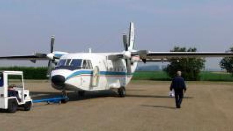
A fully-polarimetric L-band radar system with 1m resolution was realised in the summer of 2010. The first commercial flight campaign was carried out in summer/autumn 2010 in the north of Italy for an Italian client. The sensor was installed on a CASA C-212 aircraft and a picture of the airplane before take-off is displayed in Fig. 1.
The radar showed accurate and reliable mapping performance, combined with moderate penetration capabilities over forested scenarios.
Polarimetry is an important radar feature for classification purposes. In fact, radar waves can, for instance, be vertically or horizontally polarised, which means that they are more sensitive to different geometric and structural properties of the ground.
A set of polarimetric images taken above the airport of Parma in Italy is shown in Fig. 2. The given images illustrate how polarimetry adds more information to radar imaging and that it can be used for classification, based on different scattering mechanisms from different parts of the observed scenery. New data acquisition campaigns commissioned by the same customer are planned for September/October 2011.
SNOWSAR
A fully-polarimetric, dual-frequency (X- and Ku-bands) SAR was developed during the winter 2010/2011 for investigating the scattering characteristics of ice and snow. The work was commissioned to MetaSensing by the European Space Agency (ESA), in support of the candidate Earth Explorer mission CoReH2O (Cold Regions Hydrology High-Resolution Observatory). MetaSensing designed and built the SAR system complying with the stringent requirements of the Agency and operated it successfully in the harsh weather conditions of Lapland in March 2011, just before the end of the winter and the melting of the snow.
The airplane adopted for the campaign was a Cessna 208 Caravan. A set of polarimetric radar images, acquired during the campaign in Finland, is displayed in Fig. 3. In this case, the use of polarimetry also allows additional information to be extracted with respect to an optical image, and distinguishing different features in the mapped area.
Polarimetry and interferometry
The X-band radar sensor developed by MetaSensing in 2009 was operated in February/March 2011 above the area of Hoek van Holland (the harbour in the vicinity of Rotterdam) for buoy, ship and moving target detection. The sensor was operated both in polarimetric and interferometric modes on a Cessna 172 aircraft, shown in Fig. 4.
The survey was commissioned by the Joint Research Centre (JRC) and financed by the European Commission. In Fig. 5 an obtained X-band SAR image is overlaid on an aerial photograph of the same area taken from Google Earth. MetaSensing images are produced in GeoTIFF format and can therefore be opened with standard GIS software. Figure 6 displays a zoom-in of the SAR image shown in Fig. 5, relative to a work-in-progress area. A richness of details with high-resolution may be appreciated in MetaSensing's images. The terrain pattern is neatly detailed: sand drifts, roads, water basins and man-made structures are clearly distinguishable. Even the smallest details like buoys can be easily pointed out.
These aspects demonstrate the versatility of MetaSensing's products, from land classification and management, to urban planning,, cadastral updating and surveillance (detection at sea of very small ships). Future
In order to further increase the penetration capabilities of its L-band radar sensor, MetaSensing has developed a P-band radar system. At these low frequencies, dense vegetation and dry ground penetration for several metres becomes reality. The next flight campaign is scheduled for autumn 2011. The same technology will then be used for the detection of buried mines in sandy desert areas.
Besides providing solutions for commercial mapping applications, MetaSensing has also started addressing security activities.
The company has in fact recently delivered SAR units for security applications including airborne border patrolling with real-time imaging and moving target detection.
MetaSensing is constantly aware of the importance of establishing commercial partnerships with suitable partners in order to properly address the needs of a larger community of users. We are, therefore, always interested in hearing more from potential users and partners!
Comparison between MetaSensing's X-band radar image (top) and an aerial photograph from Google Earth (bottom), relative to the same area of Rotterdam harbour, taken at different times. -->

Value staying current with geomatics?
Stay on the map with our expertly curated newsletters.
We provide educational insights, industry updates, and inspiring stories to help you learn, grow, and reach your full potential in your field. Don't miss out - subscribe today and ensure you're always informed, educated, and inspired.
Choose your newsletter(s)


