New Leica FCMS 2.2 Released
Leica Geosystems (Switzerland) has released FCMS 2.2. The Leica Flight & Sensor Control Management System (FCMS) enables the most efficient Leica Geosystems sensor (ADS40, ALS50 or RCD105) survey flights. FCMS also supports any other sensor, as well as multi-sensor payloads of up to four sensors. The new Leica FCMS release brings enhancements to users including vector data and ground control points as a backdrop, simplified views for the pilot and a more flexible, multi-language configuration.
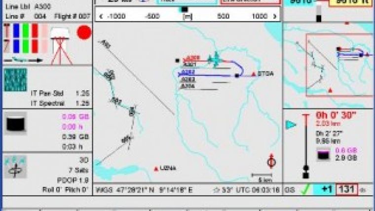
Leica FCMS Flight & Sensor Control Management System makes survey flights an easier task for the operator and the pilot, guiding them through all phases of the mission. During flight execution, FCMS displays independent views to the operator and to the pilot. While the pilot gets displayed views optimised for flight navigation, the operator may simultaneously use an in-flight evaluation view to control flight execution progress and quality control. For post-flight mission analysis, Leica FCMS stores all data required. This is essential for optimal management of aerial survey projects, especially for large projects flown with more than one aircraft.
Leica FCMS performs all tasks, including flight guidance, sensor release and sensor monitoring, on a single man-machine interface. Since the software provides automated operation, user interaction is minimized. Operation is intuitive and novice users are able to operate the sensor after a very short training period. Precise aircraft positioning is made simpler for the pilot due to the sophisticated flight guidance information provided during all phases of the survey flight.
Leica FCMS is designed to support various airborne sensor types as well as multi-sensor systems. Perfect integration of hardware and software into one single system is the key for very effective control. Consisting of high-quality airborne components, Leica FCMS optimizes the data collection and processing workflow starting with flight planning and ending with deliverable data.

Value staying current with geomatics?
Stay on the map with our expertly curated newsletters.
We provide educational insights, industry updates, and inspiring stories to help you learn, grow, and reach your full potential in your field. Don't miss out - subscribe today and ensure you're always informed, educated, and inspired.
Choose your newsletter(s)


