Sentinel-1 Satellites Combine Radar Vision
Following its orbital manoeuvres, the recently launched Sentinel-1B satellite reached its designated orbit position on 15 June. It is now orbiting Earth 180° apart from its twin, Sentinel-1A, at an altitude of almost 700km. With both satellites finally in the same orbit, together they can cover the whole globe every six days. Now, for the first time, they have combined to show their capability for revealing even small deformations in Earth’s surface.
The two-satellite ‘radar vision’ mission for Europe’s Copernicus programme carries an advanced radar to provide an all-weather, day-and-night supply of imagery of Earth’s surface. It has now been demonstrated that future images acquired by the pair can be merged to detect slight changes occurring between scans. This technique is particularly useful for generating accurate maps of surface deformation over wide areas, such as those caused by tectonic processes, volcanic activities or landslides. It is also an ideal tool for monitoring glacier flow and changes in Arctic and Antarctic ice shelves.
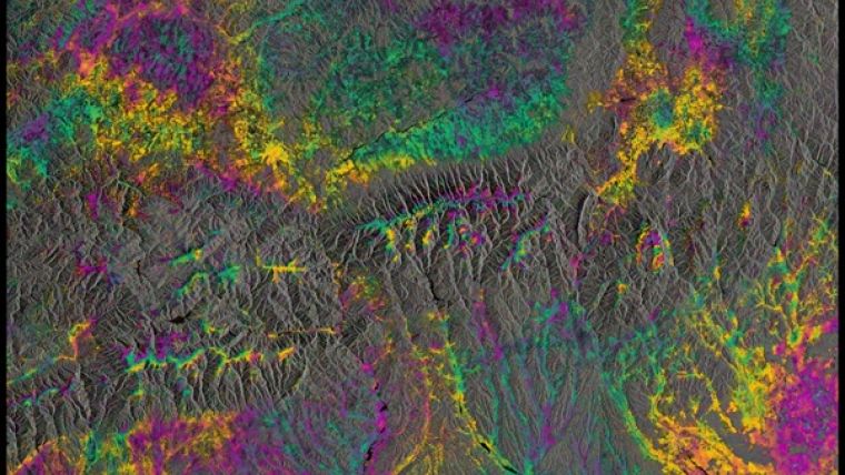
Interferogram
Sentinel-1’s first such paired ‘interferogram’ combined a Sentinel-1A scan over southern Romania on 9 June with a Sentinel-1B acquisition over the same area just one day before reaching its target orbit position. Another interferogram over northwest Romania was produced shortly after Sentinel-1B reached its final orbit.
The rainbow-coloured patterns are related to topography, and they demonstrate that the two satellites’ identical radars are accurately synchronised, pointing in the same direction and that the satellites are in their correct orbits. Once commissioning is completed in mid-September, the pair will be ready to deliver data for the systematic and routine monitoring of Earth surface deformation and ice dynamics.
Ramón Torres, ESA’s Sentinel-1 project manager, stated after the great success of generating the first radar image less than three days after liftoff, he is very happy to report another outstanding success as it is the generation of the first interferograms with Sentinel-1B on the same day that we reached the orbital position, 180° apart from Sentinel-1A. It is of paramount importance to the mission that was demonstrated, at the first try, that the two Sentinel-1 satellites work very well together.
Source: ESA.

Value staying current with geomatics?
Stay on the map with our expertly curated newsletters.
We provide educational insights, industry updates, and inspiring stories to help you learn, grow, and reach your full potential in your field. Don't miss out - subscribe today and ensure you're always informed, educated, and inspired.
Choose your newsletter(s)


