Survey-grade 3D Point Clouds without GNSS for Efficient Rail Maintenance
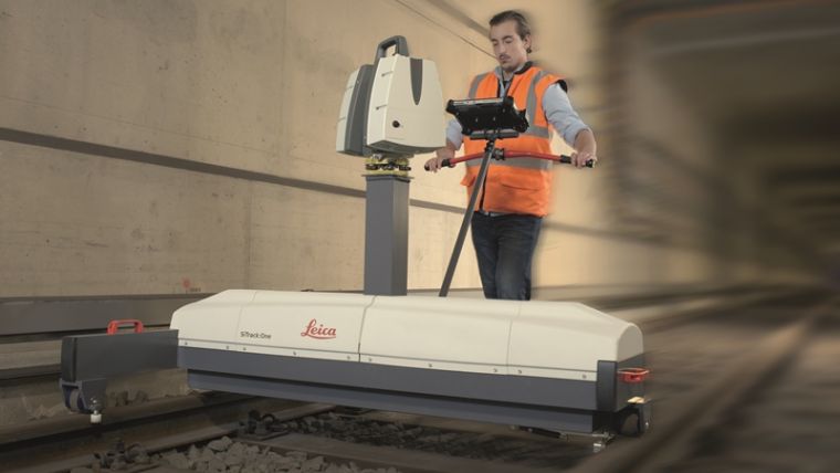
At this year’s Intergeo, Leica Geosystems released SiTrack:One, a highly accurate rail track maintenance and refurbishment system incorporating the Leica ScanStation P40 to generate 3D point clouds. SiTrack:One ensures complete coverage of the entire rail infrastructure surface without the need to receive GNSS signals for position information. With a mounting design, this total solution for rail maintenance and refurbishment produces synchronised engineering, survey-grade 3D point clouds for accurate as-built drawings.
The Leica ScanStation P40 can either be mounted vertically in the centre of the rails or inverted directly over the rail track. With multiple mounting options, the SiTrack:One provides a complete solution for any rail maintenance need. Rail bridge sleeper replacements can be measured quickly generating a numbered as-built replacement plan for each individual sleeper on a rail bridge.
The sophisticated system is equipped with two powerful Distance Measurement Instrument (DMI) or Odometers that provide accurate positioning in GNSS-denied areas, such as underground railway tunnels or underground subway networks. The system’s on-site calibration process guarantees permanent alignment of the relative position between the sensors and its on-board inertial measurement unit, guaranteeing position accuracy.
First user
The German engineering firm Vermessungsbüro Riemenschneider was the first to use the SiTrack:One by Leica Geosystems. When converting existing railway tracks in the course of track maintenance for the Deutsche Bahn, the firm required complete, accurate and consistent information on existing tracks, clear structure gauge, route topography and civil engineering works. With the SiTrack:One, Vermessungsbüro Riemenschneider experienced significant workflow gains by leveraging the highly accurate point clouds directly into the engineering process.
The SiTrack:One guaranteed the complete survey of railway sidings with a minimum stay of surveying personnel in the danger zone of rail transport, said dipl-ing Andreas Riemenschneider, principal of Vermessungsbüro Riemenschneider. Thus, the costs of security measures were significantly reduced. The system conforms efficiently to the demands for survey, visualisation, documentation, evaluation and approval of existing and new routes, all in accordance with rail transportation guidelines.
Acquired knowledge
SiTrack:One is the first solution to be released under Leica Geosystems from the acquisition of the former Technet-Rail 2010. Leica Geosystems acquired the previous firm’s specialised knowledge of geospatial big data for rail transportation networks in May to increase its mobile mapping offerings for the rail industry.
One of the goals in obtaining this specific know-how was to provide users with a dedicated tool for passenger rail networks monitoring and maintenance, and with the development of SiTrack:One, Leica is taking the first step on this roadmap, said Stuart Woods, Leica Geosystems geospatial solutions division vice president. Professionals can now trust their measurements on rail are accurate even in the most difficult conditions, he added.
The system includes software enabling data synchronisation, post-processing and feature extraction. This solution is part of the SiRail Suite, which includes the SiRailScan and SiRailManager software solutions. SiRailScan allows for a complete extraction of the railway network with engineering accuracy level, while SiRailManager, the database management tool, creates a holistic view of an operator’s railway network from point cloud to geometry and signal layers. The combination of these solutions form the SiControl platform, which conforms to the requirements of the European Train Control System and produces complaint rail xml outputs for full train feedback control.
For more information about SiTrack:One by Leica Geosystems, see here.

Value staying current with geomatics?
Stay on the map with our expertly curated newsletters.
We provide educational insights, industry updates, and inspiring stories to help you learn, grow, and reach your full potential in your field. Don't miss out - subscribe today and ensure you're always informed, educated, and inspired.
Choose your newsletter(s)


