The Atlantic Slave Trade Project
Documenting the Trans-Atlantic Slave Trade Using 3D Technologies
Advertorial
In the fall of 2014, Trimble embarked on a joint program with CyArk to digitally preserve 10 cultural heritage sites across western Africa and the Americas that were associated with the extensive and exploitative Trans-Atlantic slave trade prior to the American Civil War.
CyArk is a California-based nonprofit dedicated to the digital preservation of the world’s cultural heritage sites; the name comes from the combination of the words "cyber" and "archive." Its mission is to create a free, 3D online library of the world’s cultural heritage sites to ensure that they are available to future generations, while making them uniquely accessible today. CyArk offers a publicly accessible Web archive for its documented archaeological sites: cyark.org.
The First Site: Natchez National Historical Park
CyArk and Trimble kicked off the Atlantic Slave Trade Project with the digital preservation of Natchez National Historical Park in Natchez, Mississippi. Resting along the Mississippi River, the city of Natchez played a significant role in the landscape of slavery in America. Prior to the Emancipation Proclamation of 1863—which changed the federal legal status of more than 3 million enslaved persons in designated areas of the South from "slave" to "free"—Natchez was home to the second-largest slave auction site in the country, with traders transporting tens of thousands of enslaved people from Virginia, Maryland, the Carolinas and Kentucky to the markets and auction sites of New Orleans and Natchez.
The Natchez National Historical Park includes two prominent historical residences: the William Johnson House, an iconic brick house that provides valuable insight into the less-documented experiences of the free black community living in Natchez in the early 1800s; and the Melrose House, a Greek Revival estate home that allows for a closer understanding of the daily life of those enslaved.
Onsite at Natchez, Trimble TX8 and TX5 3D laser scanners were used to document the Johnson and Melrose Houses, as well as four slave quarters on the Melrose Estate property. In addition to 3D laser scanning, GIS and survey data with photo panoramas were collected using the Trimble V10 imaging rover. Professionals from geospatial solution provider Navigation Electronics, Inc. (NEI) helped capture the data.
In just three days, the field capture team scanned and surveyed the interior and exterior of both houses, as well as their surroundings. During this time, the field team also captured high-resolution photography and conducted interviews with the park superintendent, as well as park managers, volunteers, Natchez experts, and prominent figures at the Natchez Museum of African Art and Heritage.
While the data field capture provides a baseline for documentation of the Natchez National Historical Park site, derivatives from the data make it possible for the public to interact with the site in new ways. Online visitors can take a virtual tour of both the Johnson and Melrose houses and explore them through panoramic photography. A detailed 3D model, created from the panoramic imagery using Trimble’s SketchUp 3D modeling software, is also available on the website to introduce virtual tourists to the style, structure and geographic location of the slave quarters at the Melrose House.
In March and April of 2015, two other significant sites—the Annaberg Sugar Plantation on St. John in the U.S. Virgin Islands, and the Cidade Velha on Cabo (Cape) Verde, an island republic off the coast of Western Africa—were also documented.
The Second Site: Annaberg Sugar Plantation
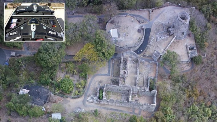
Denmark took control of St. John in 1754, establishing and operating sugar plantations all over the island through 1848, when slavery ended in the region. The Annaberg Sugar Plantation ruins are one of the finest remaining examples of Dutch Colonial Era industrial agriculture on the island. A modest holding in 1722, the plantation was enlarged and modernized in 1796 when James Murphy purchased and consolidated several plantations, adding one of the largest windmills on the island, plus the sugar factory. The ruins of Annaberg encompass the slave quarters, windmill and processing factory, a guard house, and the owner’s mansion.
Situated in the eastern Caribbean, St. John was one of the worst places a person captured and transported across the Atlantic Ocean could disembark. Working brutal 18- to 20-hour days during the sugar harvest, enslaved workers suffered the relentless heat of the Caribbean sun and boiling-house furnaces, along with exposure to dangerous machinery and scalding liquids. The Annaberg slaves farmed 1,300 acres of sugarcane and produced 100,000 tons of sugar a year.
In 1917, the U. S. purchased St. John from Denmark for $25M in order to establish a naval base, making the island an unincorporated U.S. territory. Since 1956, approximately 60 percent of St. John has been protected as Virgin Islands National Park, administered by the U.S. National Park Service. CyArk and Trimble worked closely with the Virgin Islands National Park archaeologist, Ken Wilde, to identify key areas of interest and to better understand how to document them. It took a team of nine people five days to completely capture the Annaberg site. Digital surface models, high-resolution orthorectified imagery, detailed point clouds of the structures, SketchUp 3D models of the site and panoramic terrestrial imagery of specific features paint a comprehensive picture of the entire area. Several Trimble technologies were used to document the Annaberg Sugar Plantation, including TX8 scanning, UX5 unmanned aircraft system aerial photogrammetry and the V10 imaging rover with GNSS. The scale, variety and quality of captured data is one of the most complete and comprehensive site documentation efforts on record for a project of this type.
View the Annaberg site; find in-depth information; and see the full media gallery.
The Third Site: Cidade Velha
The Cidade Velha site capture has been completed, with data processing still underway. Expect live datasets in the coming months, which can be viewed online.
In addition to contributing to a greater understanding of the complex Trans-Atlantic slave trade system, these digital preservation projects will enable free public access and standards-based curriculum around individual sites and the global slave trade at large. Documentation and inclusion in the digital preservation of the Atlantic slave trade theme will greatly enhance the visibility of these sites, while bringing cutting-edge technologies to assist in site conservation and interpretation.
Read more about these preservation projects in Lidar magazine’s March issue, a SketchUp blog post, or the project site itself.

Value staying current with geomatics?
Stay on the map with our expertly curated newsletters.
We provide educational insights, industry updates, and inspiring stories to help you learn, grow, and reach your full potential in your field. Don't miss out - subscribe today and ensure you're always informed, educated, and inspired.
Choose your newsletter(s)


