Wine Improves with Very High-resolution Satellite Imagery
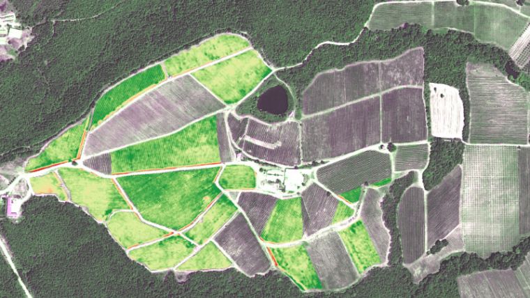
Researchers in Greece reveal that using satellite imagery can improve the quality of wine and help manage the grape harvest. In a recent case study published by European Space Imaging – Multispectral VHR Imagery Supports Crop Management in Vineyards, the Remote Sensing Laboratory at the National Technical University of Athens, Greece explains the benefits of using pan-sharpened, multispectral WorldView-2 satellite imagery for improving grape quality.
They tested the data information quality in four vineyards in northern Greece comparing data gathered on the ground with the information collected via the satellite sensor at the same time on the same day with the aim of understanding if there is a benefit using Earth observation data.
Normally grapes need to be tested throughout the growing season by people walking through the fields using handheld spectrometers. The data collected is used to determine when nutrients, pesticides and additional water should be applied to optimise grape growth. But gathering this way is a slow process, expensive and it is hard to analyse the whole field at once.
Data Comparison
The University worked with TotalView, a European Space Imaging reseller in Greece, to coordinate the collection of the satellite imagery concurrent to the collection of the field measurements. For them this was the best way to be able to obtain two comparable two data sets.
WorldView-2 (data) provided atmospherically corrected images that correlated with the field observations, according to Konstantinos Karantzalos, assistant professor at the University’s Remote Sensing Laboratory. He sees a commercially viable service involving the creation of high-resolution vegetation index maps for winemakers could become reality in the near future. The accuracy and value of these maps will be enhanced through collection of satellite data at multiple times during the growing season.
The study proved that information from satellite imagery is of equal quality to the ground-based measurements but can cover a greater area of the vineyard in a shorter period of time. This means that viticulturists who decide to include satellite information in their crop management planning could benefit from improved harvests.
Of course, the real aim is to assist the winemakers to produce more and better wines, which will also be a positive outcome for wine lovers.

Value staying current with geomatics?
Stay on the map with our expertly curated newsletters.
We provide educational insights, industry updates, and inspiring stories to help you learn, grow, and reach your full potential in your field. Don't miss out - subscribe today and ensure you're always informed, educated, and inspired.
Choose your newsletter(s)


