3D Routing Through OpenStreetMap-3D
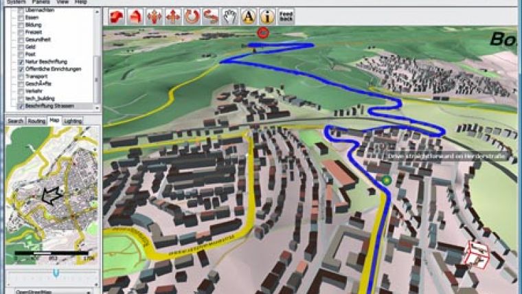
Users now can plan a route online at OSM-3D.org and then interactively fly along the route presented in 3D. Currently the routing is available for cars (fastest/shortest) as well as for pedestrians or bicycles for all of Germany. It is also possible to create an animation that follows the 3D route automatically. The application is powered by an extended version of OpenRouteService.org and uses the free data from OpenStreetMap.org and the Open Location Services (OpenLS) specifications of the Open Geospatial Consortium (OGC).
The data from OSM-3D.org is generated by combining data from OpenStreetMap and SRTM elevation data.
Start and Stop of the route can be specified by picking into the 3D scene or by searching for adresses using the OSM-based OpenLS geocoder. Turn by turn instructions are available for several languages. Further options inludce a graph of the height profile of the route and others.
A further version was used for demonstrating even 3D Indoor Routing within the OGC OWS6 Testbed. The new download version of the XNavigator W3DS-Client also supports the integration of dynamic sensor data (air pollution, water gauges etc.) into the 3D scene through the OGC Sensor Observation Service (SOS). OSM-3D.org applies the OGC Web 3D Service (W3DS) draft specification as interface to the 3D scene that is streamed to the client.

Value staying current with geomatics?
Stay on the map with our expertly curated newsletters.
We provide educational insights, industry updates, and inspiring stories to help you learn, grow, and reach your full potential in your field. Don't miss out - subscribe today and ensure you're always informed, educated, and inspired.
Choose your newsletter(s)


