First Zebedee 3D Mobile Mapping Project
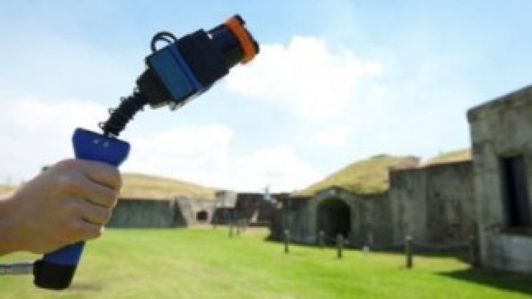
Australian researchers are using the novel mobile laser 3D mapping system called Zebedee to preserve some of the country’s oldest and most culturally significant heritage sites. The handheld 3D mapping system is developed by CSIRO and can scan an environment as an operator walks through it.
The new joint research initiative between CSIRO and The University of Queensland aims to collect detailed 3D maps of historic sites of Moreton Bay. With the assistance of Queensland Parks and Wildlife Services, the research team have collected data from a number of heritage sites including the 19th-century Brisbane River defences at Fort Lytton and Peel Island's leper colony buildings.
At the core of the technology, developed by CSIRO's Autonomous Systems Lab in Brisbane, is a laser scanner that swings back and forth on a spring to capture millions of detailed measurements. Zebedee gives researchers the ability to reliably map an environment in 3D by simply walking through it.
This technology is ideal for cultural heritage mapping, which is usually very time consuming and labour intensive. It can often take a whole research team a number of weeks or even months to map a site with the accuracy and detail of what we can produce in a few hours, said Dr Jonathan Roberts, director of CSIRO's Autonomous Systems Lab.
Zebedee has allowed the researchers to capture a detailed record of several key cultural heritage sites ranging from those which are fragile and at risk of damage through natural disasters to those which are remote and difficult to get to, explained professor John Macarthur, dean and head of the School of Architecture at The University of Queensland.
Macarthur said his team is looking to use these maps in the future to create an archive of rich data about cultural heritage sites, which enables the researchers to analyse them without costly and time consuming hand measuring. From this, they have already analysed important aspects of Australian history. For example, the detailed map of Peel Island's many small buildings allowed them to analyse architecture used to racially segregate people within the leper colony. The point cloud data clearly depicts how cramped and crowded the living quarters for Indigenous people were, when compared to the non-Indigenous people who lived in their own huts with scenic verandas, he added.
The research will be officially launched by the Honourable Andrew Powell, Queensland's Minister for Environmental Protection and Heritage during an event to mark the beginning of Australia’s National Heritage Week celebrations at Fort Lytton today.
Zebedee
Zebedee is a handheld 3D mapping system developed by CSIRO that can scan an environment as an operator walks through it. The system produces a 3D map of the environment as well as an accurate record of the trajectory followed. The primary sensing technology utilised is Lidar, in which an infrared laser measures ranges to surfaces in the environment.
The distinguishing feature of Zebedee’s design is that the laser scanner is mounted on a spring, which provides a lightweight solution for ensuring a wide scanning field of view. The spring converts the natural motions of the operator into a suitable sweeping motion of the scanner. A low-cost inertial sensor provides rough measurements of the spring’s rotations. Specially designed software is able to convert the raw range and inertial measurements into a 3D map, represented as a pointcloud, which consists of millions of points expressed in a common coordinate frame.

Value staying current with geomatics?
Stay on the map with our expertly curated newsletters.
We provide educational insights, industry updates, and inspiring stories to help you learn, grow, and reach your full potential in your field. Don't miss out - subscribe today and ensure you're always informed, educated, and inspired.
Choose your newsletter(s)


