New Feature Extraction Function Added to Popular Lidar Data Viewer
uGRIDD Corporation has released a new built-in feature in its popular Lidar data viewer, uPANO. This feature will offer uGRIDD customers a web-based tool to extract XYZ coordinates directly from uPANO, a proprietary panoramic viewing interface for Lidar data, panoramic photo and 3D CAD/BIM models.
Lidar data, typically captured by terrestrial, mobile and airborne devices, has found its position during the last 20 years in many industries, such as infrastructure engineering and management. As a member in the Big Data family, Lidar data is worthy to bank. However, is hard to manage and view due to its size and complexity. A specialised complex and expensive software suite is usually necessary to do the job, so that only well-trained professionals would have access to Lidar data.
Panoramic viewing
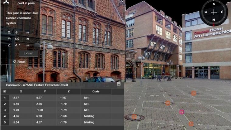
uGRIDD first released LiDAR2Map in 2015. This web-based tool offers low-cost panoramic viewing of Lidar data from vantage points chosen by the data publisher. Many Lidar data service providers utilise LiDAR2Map as part of the data submittals to clients. The clients do not have to invest in any software other than a standard web browser. To further meet the demand of extracting features from Lidar data, uGRIDD not only enables users to pick XYZ coordinates from the interface, but also allows them to enter a description, code and/or URL, and tabulate the data so that the extracted features can be exported as a CSV file. It then can be imported into other software systems.
This is going to disrupt some of the current workflows in the industry and enable everyone who has access to the Lidar dataset to build their own geodatabase of the features that are important to them. The extracted data points has many uses, including CAD, mapping, GIS, BIM and asset management systems.
This feature is enabled in two uGRIDD uSHOW products: LiDAR2Map and TruView2Map. It is also available in Pano2Map, when combined with Lidar data. For more information see here.

Value staying current with geomatics?
Stay on the map with our expertly curated newsletters.
We provide educational insights, industry updates, and inspiring stories to help you learn, grow, and reach your full potential in your field. Don't miss out - subscribe today and ensure you're always informed, educated, and inspired.
Choose your newsletter(s)


