Solar-powered UAS for Mapping Launched at Esri User Conference
At the Esri International User Conference Imaging and Mapping Forum, Flightline Geographics has announced the first solar-powered UAS specifically designed for professional mapping applications. By integrating solar panels within the wings, flight times have doubled allowing much larger areas to be mapped in a single flight.
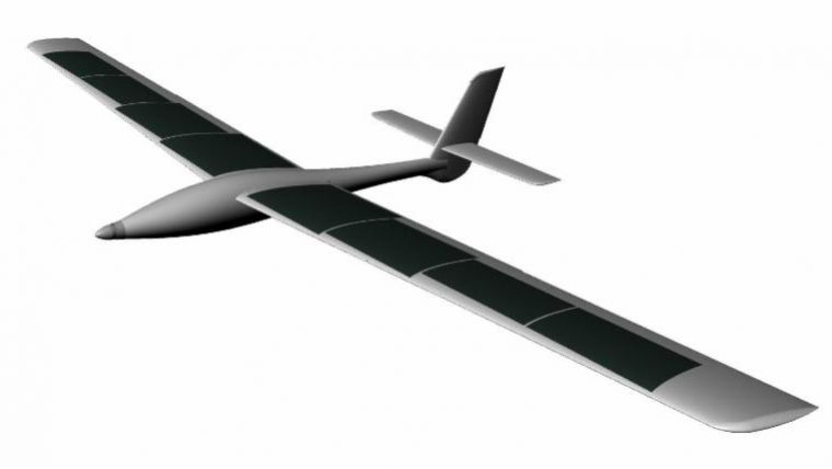
The Hawkeye Systems GS-1000 is the fourth generation of a MILSPEC UAS design, having a combination of an Esri GIS-driven ground control station and proven safety features including a parachute landing system. The GS-1000 is designed specifically for GIS mapping and actually uses Esri GIS technologies throughout the entire workflow from planning, to flight operations, to processing and delivery.
The GS-1000 can capture 3D aerial photography for mapping terrain and detailed HD base map imagery at up to 2.5cm resolution. A multi-spectral mapping sensor provides agricultural customers with GIS-ready data for vegetative health and other agricultural uses.
Flight duration
One of the challenges for small UAS has been short flight duration of 1-2 hours, which limits how much area can be mapped in a single flight, said Devon Humphrey, founder and CEO of Texas-based Flightline Geographics. By adding a solar capability, it is now possible to mapping up to more than 10 square kilometres miles, in a single flight of four hours. This takes advantage of the entire window of mid-day sunlight for both the solar panels and the camera sensor.
Commercial use
With over 11 years of UAS operations and development experience, the Hawk GS-1000 is designed by UAS operators for UAS operators. Combining customer feedback and global exposure to many different markets the Hawk GS-1000 focuses on professional grade acquisition for repeat commercial use, said Rowland Harrison, director of Hawkeye Systems in New Zealand. FlightlineGeo has set the bar high for UAS mapping in the USA. Now, the GS-1000 provides a platform for all-day capture using available renewable energy, he added.
Flightline Geographics is the exclusive distributor for the USA, Latin America, including South America and the Caribbean. For more information or to download complete specifications for the GS-1000, visit the Flightline Geographics website.

Value staying current with geomatics?
Stay on the map with our expertly curated newsletters.
We provide educational insights, industry updates, and inspiring stories to help you learn, grow, and reach your full potential in your field. Don't miss out - subscribe today and ensure you're always informed, educated, and inspired.
Choose your newsletter(s)


