Teledyne Optech to Launch Automated Airborne Surveying at GEOINT 2016
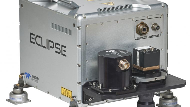
Teledyne Optech will showcase its latest airborne systems including the autonomous Optech Eclipse at the United States Geospatial Intelligence Foundation’s GEOINT symposium in Orlando, Florida, USA, from 15-18 May. The Eclipse is being introduced as the world’s first autonomous airborne collection system for active and passive data and has been described as a step forward for low-cost and flexible surveying.
The system’s highly simplified operation workflow and innovative sensor motion detection system let pilots manage surveys on their own, eliminating the need for an in-aircraft operator and drastically reducing survey costs. To minimise maintenance costs and down time, the Eclipse Lidar system uses a rugged polygon scanner, and an integrated camera with a fully electronic shutter. These features make the Eclipse suitable for many groups to start collecting high-accuracy spatial data and camera imagery remotely for small-area and corridor surveys.
Airborne Lidar systems
Visitors can also discover the advanced capabilities of the full line-up of Teledyne Optech airborne Lidar systems. For wide-area Lidar surveys, the Optech Galaxy uses SwathTRAK technology to maintain efficiency and avoid data gaps caused by rugged terrain, and is completely configurable with Teledyne Optech’s array of thermal, multispectral and RGB cameras. The Optech CZMIL Nova meanwhile is known for its performance in bathymetric applications, surveying even in highly turbid waters to map navigation channels and assess the marine environment, and is available for rental through the CZMIL Project Program. Finally, the multispectral Optech Titan uses three Lidar channels (one green, two infrared) to bridge the gap between topographic and bathymetric surveying and improve automated target classification efforts.
All these solutions will be displayed at the GEOINT symposium at booth 1036, where Teledyne Optech’s sister companies Teledyne DALSA, Teledyne Brown Engineering, and Teledyne Imaging Sensors will display their own complementary imaging technologies.
Find out more at www.teledyneoptech.com.

Value staying current with geomatics?
Stay on the map with our expertly curated newsletters.
We provide educational insights, industry updates, and inspiring stories to help you learn, grow, and reach your full potential in your field. Don't miss out - subscribe today and ensure you're always informed, educated, and inspired.
Choose your newsletter(s)


