UAV Successfully Deployed for Air Accident Investigation
The Taiwan Aviation Safety Council (ASC) successfully deployed a cyberQuad UAV as part of its investigation into the crash of a TransAsia Airways ATR-72-500 aeroplane on the island of Hoko, west of Taiwan. The use of UAVs is a growing trend among air crash investigators worldwide, due to their ability to access remote locations or to quickly perform a site survey while gathering data at a lower cost than manned aircraft alternatives.
Flight 222 accident investigators used a ScientificAerospace cyberQuad quadcopter to assists their investigation. The UAV carried a digital camera and other sensors to survey and map the path of the aircraft during the final seconds of its flight to Magong Airport in Taiwan.
An investigator with the Aviation Safety Council (ASC), Brian Kuo, said the drone’s pre-programmed survey took approximately 90 minutes to complete which is more efficient and less costly than hiring and equipping a helicopter for the operation.
Site surveys
The ASC, which had been studying the idea of using a sUAS for investigations for several years, originally planned to use the cyberQuad for site surveys of accidents in difficult-to-access remote or mountainous areas. It regularly practices this task in joint drills with Singapore, Japan and other East Asian countries. Many of those countries are also moving ahead with plans for using drones, Kuo said.
The ASC team was sent to Hoko the day after the crash. Although Magong Airport is neither mountainous nor remote, the group opted to take the quadcopter along to see how well they could finish the site-survey task in a populous area, Kuo said.
Collecting and processing
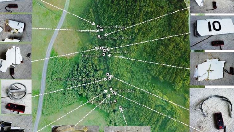
Martin Chen, an engineer with the ASC, flew the cyberQuad at 100m (328ft) altitude through the survey area. He collected digital images along with GPS position, altitude and other variables. Chen then processed that data afterward to determine the height of obstacles with the help of commercial software and a digital terrain map. Investigators also embedded the geotagged locations of recovered components within overhead images taken by the UAV, which shows the actual conditions of the environment after the crash, rather than an aerial map taken some time before.
Final report
According to the final report by the Aviation Safety Council (ASC), the Flight 222 pilots descended below the minimum-descent altitude during a non-precision approach in heavy rain to Runway 20, without having visual contact with the runway. The pilots ultimately initiated a go-around, but the aircraft contacted bushes, trees and ultimately a housing complex shortly thereafter.
Surveying payload
The cyberQuad deployed for TransAsia accident investigation was fitted with a servo stabilised 16MP DSLR surveying payload. ScientificAerospace have recently developed a next-generation precision surveying solution TopoDrone 4Scight, with brushless gimbal stabilised 20MP DSLR and high precision L1/L2 PPK GNSS for direct georeferencing, negating the need for ground control surveying. For more information, please visit ScientificAerospace.

Value staying current with geomatics?
Stay on the map with our expertly curated newsletters.
We provide educational insights, industry updates, and inspiring stories to help you learn, grow, and reach your full potential in your field. Don't miss out - subscribe today and ensure you're always informed, educated, and inspired.
Choose your newsletter(s)


