Matija Zupan
Matija Zupan is a certified drone operator and QA manager at Slovenian geospatial software developer 3Dsurvey. He made his way into photogrammetry through geology, geotechnical engineering, and natural hazard modelling...

Matija Zupan is a certified drone operator and QA manager at Slovenian geospatial software developer 3Dsurvey. He made his way into photogrammetry through geology, geotechnical engineering, and natural hazard modelling...
Lidar, short for Light Detection and Ranging surveying, represents a sophisticated measuring system leveraging the power of light. Widely recognized for its versatility, Lidar is extensively applied in diverse fields...
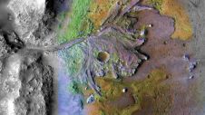
Using ground-penetrating radar, NASA’s Perseverance rover has uncovered compelling evidence of ancient lake sediment on Mars. This confirms the longstanding hypothesis that the Red Planet was once a warm, wet...
Terrestrial Laser Scanning (TLS) enables 3D coordinates to be obtained of points which can be georeferenced with respect to a national geodetic system using GNSS (Global Navigation Satellite System). Textures...
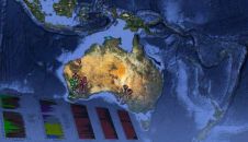
Mining industry explorers, earthquake and climate-change scientists, and members of the public can now access a 'stack' of information about Australia's geology at the click of a button. Developed by...

At the 2nd Virtual Geology Conference (VGC 2016) from 22-23 September 2016, geomatics met the geosciences in the beautiful fjord town of Bergen in western Norway. This follow-up to the...
This site uses cookies. By continuing to use this website, you agree to our Cookies Policy. Agree