Matija Zupan
Matija Zupan is a certified drone operator and QA manager at Slovenian geospatial software developer 3Dsurvey. He made his way into photogrammetry through geology, geotechnical engineering, and natural hazard modelling...

Matija Zupan is a certified drone operator and QA manager at Slovenian geospatial software developer 3Dsurvey. He made his way into photogrammetry through geology, geotechnical engineering, and natural hazard modelling...

Amy Nicol is the sales and marketing assistant at Slovenian geospatial software 3Dsurvey. She has over a decade of experience in sales and communication, working in an array of different...

Videogrammetry can be seen as a natural progression from photogrammetry. So how can videogrammetry improve and enhance data collection for surveying professionals? This article explores its intricacies through case studies,...

Presenting the latest developments in aerial mapping, products and services. Intriguing real-life projects provide insights into advanced aerial photogrammetry and Lidar in practice. Moreover, this edition looks at how AI...

In the ever-evolving landscape of climate change, geospatial science emerges as a key player in navigating the complexities of our transforming world. The European Association of Aerial Surveying Industries (EAASI)...

SimActive has reported that the use of its Correlator3D product along with ground control points can enhance, extend and validate photogrammetry projects. GCPs are critical in photogrammetry projects, but there...
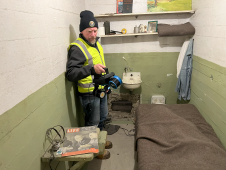
The rugged 22.5-acre site of the notorious US island prison Alcatraz has been digitally captured in a world-leading project involving multiple mapping technologies. With the team camped in the jail’s infamous cells for three weeks during the cold San Francisco winter, this historically, biologically and architecturally important location was recorded in unprecedented 3D detail. We discussed the project with project head Pete Kelsey and team member Dr Jeremy Sofonia. The rugged 22.5-acre site of the notorious US island prison Alcatraz has been digitally captured in a world-leading project involving multiple mapping technologies. With the team camped in the jail’s infamous cells...

3D visualization is at the heart of many geospatial data applications. Progress in 3D visualization has drastically reduced barriers to entry for new products based on large datasets, thanks to...

Mosaic has partnered with Movella aimed at redefining precision and efficiency in mapping and 3D reconstruction projects. Mosaic is specialized in mobile mapping camera systems, while Movella is a renowned...

Visitor registration is now open for GEO Business, the UK's largest geospatial event. The free-to-attend expo, tailored for geospatial professionals seeking to harness the potential of location intelligence, will return...
This site uses cookies. By continuing to use this website, you agree to our Cookies Policy. Agree