Aibot X6 Replaces Tachymeter
Thanks to the accurate management of the camera resolution and the control of speed, direction and position, the Aibot X6 captures a cartographic area through reinterpretation of conventional photogrammetry. The...
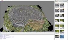
Thanks to the accurate management of the camera resolution and the control of speed, direction and position, the Aibot X6 captures a cartographic area through reinterpretation of conventional photogrammetry. The...
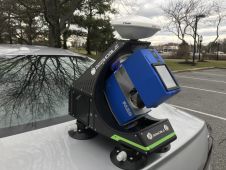
BAM Infra recorded 3D road models using a Faro terrestrial laser scanner with the innovative BeeMobile mobile mapping system at various locations across the Netherlands in 2020. BAM Infra is part of...
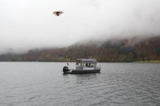
What is the best way to generate a high-precision 3D model to estimate the storage capacity of a lake that is surrounded by mountains? Rapid weather changes, low clouds and...
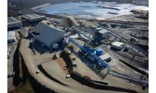
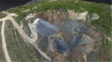
A growing number of mining companies are employing unmanned aerial vehicles (UAVs). Equipped with digital cameras, such remote-controlled small aircraft generate high-resolution aerial imagery which can be further processed to...

geo-FENNEL – An constant entity in measuring technology and surveying If it doesn't fit, it'll be made to fit – far from it! With the precise and high-quality point and...
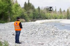
The lower area of the Bavarian Upper Alz River in Germany, which was severely affected by a chemical accident in March 2012, is to be fully revitalised and regenerated. The...
The full feature is online at http://member.gim-international.com/. Please subscribe for free using the Subscribe button in the left hand column. Monitoring is one of the main tasks in engineering geodesy....
UAS mapping is widely accepted as a new method for acquiring spatial image data. The main business opportunities clearly lie in projects which are too small to be of interest...
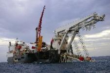
Final permission has been granted to Nord Stream AG to start construction of a natural-gas pipeline through the Baltic Sea. All permits required by the four countries through whose territorial...
Everyone who truly matters in the geomatics and surveying-related business will be travelling to Germany ¨C or more precisely to the Bavarian city of Nuremberg ¨C in the last week...
This site uses cookies. By continuing to use this website, you agree to our Cookies Policy. Agree