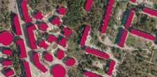
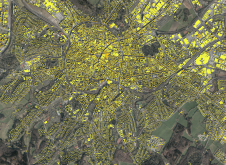
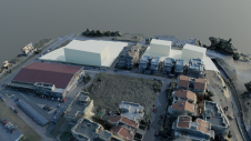
Article Archive

An extensive archive of all articles published on GIM International

A journey through the Dutch ‘Geospatial Valley’

A journey through the Dutch ‘Geospatial Valley’

Two members of the 'GIM International' and 'Geo-matching' team recently hit the road to explore an emerging hub of geospatial tech activity: the Dutch province of Groningen. There, they took a closer ...

A Data Driven OECS Region with Dr. Didacus Jules

A Data Driven OECS Region with Dr. Didacus Jules

Mapping the Conversations: Episode with Dr. Didacus Jules In this riveting episode of "Mapping the Conversations," host Valrie Grant sits down with Dr. Didacus Jules, the Director General of the OECS ...

30 years of geospatial standards

30 years of geospatial standards

ISO/TC 211 has been developing and maintaining a set of standards for the geospatial community for 30 years. Some standards are well known, others are used without people realizing it, and – because...

Charting the course of drone and Lidar technology

Charting the course of drone and Lidar technology

'GIM International' was recently invited to attend the fifth edition of the two-day YellowScan LiDAR Convention. It took place on 18 and 19 April 2024 in the Mediterranean spring sunshine at the beaut...

Accra hosted an energetic FIG Working Week

Accra hosted an energetic FIG Working Week

The annual Working Week of the International Federation of Surveyors (FIG) was held recently in Accra, Ghana. The location of the event on the African continent placed the world’s climate-related ch...

Mixed-reality photogrammetry in focus

Mixed-reality photogrammetry in focus

The use of mixed reality in photogrammetry software has resulted in a real-time 3D inspection system that allows users to remotely access, visualize and measure the stereoscopic model simultaneously. ...

AI-powered solutions for reality capture data

AI-powered solutions for reality capture data

Seamlessly integrating multiple artificial intelligence and traditional algorithms can save time, simplify functionality and improve performance during point cloud classification and feature extractio...