Ask the Specialist: GPS Signal Tracking
Have you ever wondered about the GPS signal-tracking capabilities ‘L1P, L2E'? One of our readers asked our specialist for an explanation, and this is what he replied. We rece...
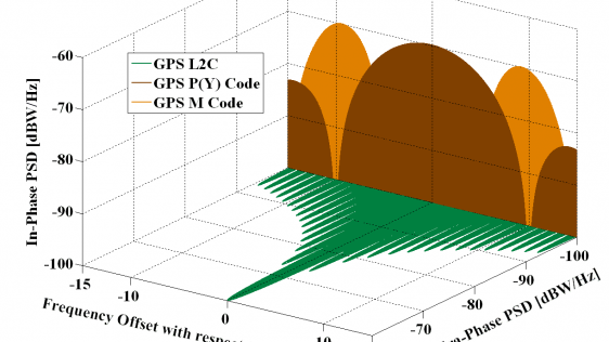
Have you ever wondered about the GPS signal-tracking capabilities ‘L1P, L2E'? One of our readers asked our specialist for an explanation, and this is what he replied. We rece...
Looking back over the past 30 years, it’s hard to believe just how far we’ve come in such a relatively short space of time. Geomatics students in the mid-1980s were exp...
Currently there are four global navigation satellite systems (GNSSs) available: GPS, Glonass, BeiDou and Galileo. The satellites of these systems are used for positioning, and the...
Deformation monitoring of glaciers is of great value to scientists with an interest in climate change. Due to the slow movements of glaciers, a semi-permanent deformation system is...
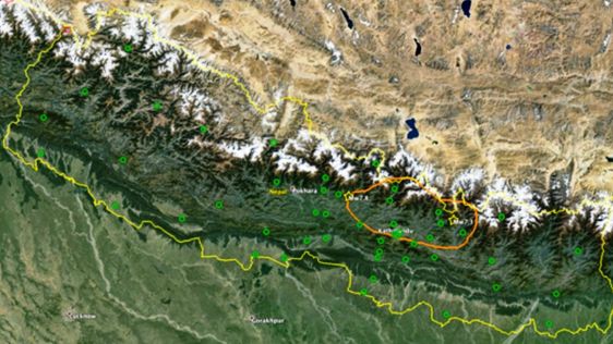
Nepal is prone to earthquakes and throughout the centuries the country’s capital city, Kathmandu, has been regularly struck by earthquakes which appear to have similar epicen...
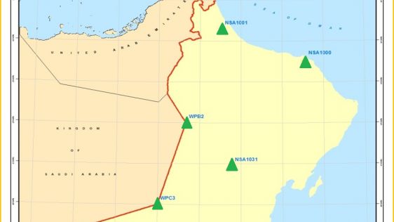
Today GNSS is widely used in Oman. High and homogeneous quality of GNSS positioning requires a geocentric datum attached to the International Terrestrial Reference Frame of which t...

A two-week field trip to Iceland – that was all they were told beforehand. After one year of studying at Delft University of Technology, MSc students headed towards this geodetical...
With so many off-the-shelf GNSS solutions is there still room for innovation? Joël van Cranenbroeck thinks so. One such solution could be based on multiple antennas. But remem...
Geomatics is not primarily aimed at investigating the causes and physical phenomena related to earthquake events. It has, however, over recent years established a fundamental role...
I enjoyed all the discussion and speculation at the GSDI 12 Conference in Singapore last October over what ‘SDI 2.0’ would look like. There were also exciting ideas a...
It's no secret that GPS systems have changed surveying. To keep pace with industry, international educational systems need to teach students how to use GPS systems and modern surve...
GeoEye-1 Imagery for GoogleGeoEye has started delivering Google with high-resolution, colour satellite imagery from its newest satellite. The GeoEye-1 satellite images currently hi...
In my March editorial I took you along on my adventure with fellow conference participants as we got lost in Prague. Despite having to hand a GPS device, we ended up at the wrong...
The use of Mobile Lidar systems enters the scene when large areas have to be surveyed at accuracy and resolution exceeding those available through aerial photogrammetry, and when u...
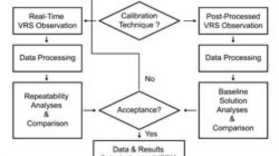
A virtual reference station (VRS) was introduced in Malaysia employing real-time kinematic (RTK) equipment. The project for updating the coordinate system, designated Coordinated C...
From entrepreneurs to incorporation to becoming publicly traded and now ISO certified, Hemisphere GPS has evolved into a major player in the design and manufacture of precision GPS...
The April 2008 issue of GIM International (page 11) summarised a project to map the Maldives as an example of how aerial photogrammetry is today applied for mapping large, complex...
The market for Global Navigation Satellite Systems (GNSS) has never looked so buoyant. Are we in the midst of a revolution or simply witnessing evolution pre-planned and destined t...
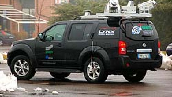
Combining Terrestrial Laser Scanning, Position and Orientation Systems and GPS receivers into a mobile mapping system enables effective mapping of large and complex terrain. The au...
Up to 70% of land in Japan is covered by forest. Since the second world war many forests have been planted with cedar and nurtured for their high productivity. However, forests ar...

Do you have an interesting idea for an article in GIM International? We are always looking for the best news and views from the geomatics industry. If you are working with the most innovative technology, have performed a challenging survey or simply want to share your perspectives on the future, please send an email to our Head of Content, Wim van Wegen: wim.van.wegen@geomares.nl. He will be more than happy to explore ways of sharing your ideas with your peers throughout the geomatics world.
This site uses cookies. By continuing to use this website, you agree to our Cookies Policy. Agree