An interview is the ultimate opportunity to get to know key figures in the geomatics industry. The interview is a regular part of the GIM International magazine and is written to reveal the view of a professional, company or organisation regarding specific topic within geomatics. Topical questions will be answered by the interviewee concerning his company, organisation, products, market views, philosophies or strategies. Apart from the regular interview, the rubric ‘5 Questions to…’ is a short article and a quick way to introduce someone or something in the business.

GIM International asked organizers Christoph Hinte from Hinte Messe and Christiane Salbach from DVW to look back on the most recent Intergeo and also to share a glimpse of next year’s event. Interge...

Read this interview with Topcon's Ulrich Hermanski for his views on the current status of the surveying profession, the key advances and the future role of surveyors. Since graduating in Geomatics Eng...

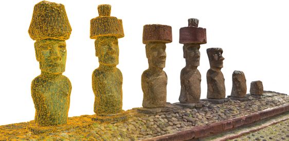
An unprecedented scientific effort to Lidar-scan the entire surface of the Earth before it’s too late... that’s how Christopher Fisher, the founder of the Earth Archive, describes his initiative. ...

Innovative developments based on quantum physics will lead to further disruption of our professional field over the coming decade, predicts Hansjörg Kutterer who, besides being president of DVW, is a...

In this interview Bobbie Kalra, founder of the rapidly growing Indian company Magnasoft, talks about digital twins and the future of the geospatial industry. Digital twins form the basis for the digit...

How are technological developments, skills shortages and the pandemic affecting the broader geospatial community in Australia? To find out, GIM International spoke to Paul Digney, president of the Sur...

Despite COVID-19 and Brexit, the UK geospatial sector has actually increased its operational capacity rather than suffering a downturn, according to James Kavanagh, director of global land & resources...

The possibilities of geoAI for monitoring Mother Nature are limitless according to Dr Nadina Galle, an ecological engineer and entrepreneur dedicated to applying emerging technologies. The use of sate...

Hydro International spoke to five leading experts about the present and future of the hydrographic industry. In this interview, John Nyberg (NOAA’s Office of Coast Survey) looks forward to a more di...

Read this farewell interview with Mathias Lemmens, who is stepping down from GIM International after 23 years as senior editor and industry figurehead. After 23 years, senior editor and industry figu...
This site uses cookies. By continuing to use this website, you agree to our Cookies Policy. Agree