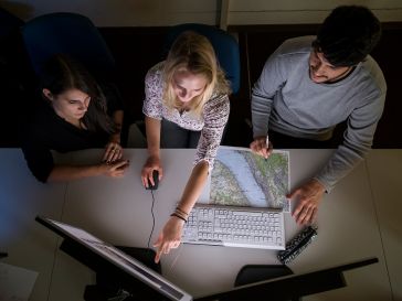
The crucial role of standards for geodata
During Peter Parslow’s term as chair of ISO/TC 211, the committee celebrated 30 years of developing and maintaining standards for the geospatial community. In this conversation with him, he reflects...

During Peter Parslow’s term as chair of ISO/TC 211, the committee celebrated 30 years of developing and maintaining standards for the geospatial community. In this conversation with him, he reflects...
Podcast
Join host Valrie Grant for a powerful conversation with Amy Coughenour Betancourt, the CEO of Cadasta, an organization at the forefront of using geospatial technology to advance land and resource righ...

Terria, a geospatial technology startup that emerged from Australia's CSIRO, is transforming how complex spatial data is organized and visualized. In this Q&A with Ana Belgun, co-founder and CEO, we h...

In this exclusive interview, Shirley Chapunza highlights the importance of young surveyors to the future of the profession, and outlines how the FIG Young Surveyors Network (FIG YSN) is inspiring, sup...

The pioneering startup Space4Good is using innovative geospatial techniques to solve global sustainability challenges. We asked managing director Alexander Gunkel how the company took its first steps ...
Podcast
In this episode of Mapping the Conversations, host Valrie Grant sits down with John Kedar, a globally recognized geospatial strategy advisor and director of John Peter Geospatial Initiatives Limited. ...

Read our analysis of the results from the most recent 'GIM International' industry survey to discover fellow professionals' ambitions, investment plans and visions for progress. Our industry survey h...

While we can have a positive impact in tackling the climate change crisis as individuals, collectively our voice becomes even more powerful. Policymakers, decision-takers, activists and champions all ...
podcast
In this insightful episode of Mapping the Conversations, host Valrie Grant sits down with Álvaro Monett, Regional Advisor on Geospatial Information Management at UN-ECLAC. Join us as we explore the e...

In this Q&A on innovation, the CEO of Aispeco explains how the startup is pushing the boundaries of geospatial data collection with its advanced platforms. These insights into his real-world experienc...

Ever since the Age of Exploration, surveying has played a crucial role in the mapping of our world. This article delves into the captivating history of surveying at a time when GPS did not exist. When...

Kenya is establishing a digital national land information management system (NLIMS) known as Ardhisasa to improve the effectiveness of the country’s land administration system. So far, progress has...

In response to the devastating effects of plastic on the Earth’s oceans, and specifically on waterways and coastal environments, the International Federation of Surveyors (FIG) has formed the Mappin...

In a recent roundtable, four prominent geospatial experts shed their light on the most impactful technological advancements over the past decade. Their insights into the evolution of the industry – ...
We encourage you to subscribe to our weekly newsletter. Subscribers also receive a digital copy of our bi-monthly magazine.