Spatial Data for Africa
A love of mathematics set one of Africa's foremost geo-information specialists on a mission to drive the development of spatial-data infrastructure across the continent Partnership and communication l...
Cartography is about describing the world in the form of maps and diagrams. Classic cartography produces paper maps but nowadays this field also encompasses Geographical Information Systems and the products produced by these systems. Cartography is heavily dependent on data from Remote sensing and Land surveying and topography for the dry part of our world and marine surveying and bathymetry for the wet parts of our world.
Cartography / GIS can be found in almost any industry vertical where it transforms the various data sources into products readily useable in for example land and water management, climate and farming and conservation.

A love of mathematics set one of Africa's foremost geo-information specialists on a mission to drive the development of spatial-data infrastructure across the continent Partnership and communication l...

With its powerful and evolving technologies, Geomatics and GIS are a force for humanitarian relief in disaster zones. Joel Myhre offers some reflections on his recent work with WHO and One Concern. It...

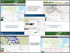
Namibia is establishing its National Spatial Data Infrastructure (NSDI) through the Namibia Statistics Agency (NSA). It has been a deliberate decision by the government of Namibia to marry location in...

Menno-Jan Kraak is the newly elected president of the International Cartographic Association (ICA). Cartographer Kraak is a professor in Geovisual Analytics and Cartography at the University of Twente...

Data visualization is inherent to humans and continuously evolves, driven by innovation. How is GIS playing a role in this? The term 'data visualization' has come into popular usage relatively recentl...

The city of Munich launched an innovation competition and provided developmental support to the winner, Holo-Light. This ultimately resulted in the development of an award-winning augmented reality-ba...

In 2017, 11 European public mapping agencies (PMAs) financed a EuroSDR project to explore the economic value of 3D geoinformation. They gained from being able to share knowledge with one another about...
Apart from being a prerequisite for a functioning market economy, environmental action and secure livelihoods, land administration systems create invaluable base data for all spatially based innovatio...

62% of young women do not see themselves staying in the GIS industry for more than ten years, this is related to the fact that at management level women are outnumbered four to one. A recent study tit...

Now that some of the core infrastructure challenges have been solved, the application layer of big data is rapidly building up. Therefore, the major GIS players have recently been focusing their att...

Niall Conway, editor of GIS Professional, spoke to Neil Brammall of Utility Information Services Ltd., a UK-based consultancy and services business which focuses on mapping buried utilities. In the fo...
Relatively new to the spatial-information world and receiving increasing attention, the geosensor network is based on a large number of interlinked,simple sensors distributed over geographical space a...

Having led the famous Wuhan University, home to the world's biggest geomatics faculty, from 2003 to 2008, professor Liu Jingnan is one of the most respected Chinese academics in geodesy and satellite ...

CycloMedia is a renowned mapping company specialised in large-scale and systematic visualisations of environments. Its headquarters are situated in The Netherlands, a country that is an excellent test...
Today the computer power of handheld devices is comparable to the desktop computers of a few years back. Together with rapid adoption of the internet, this progress has triggered fitting mobile GIS sy...
This site uses cookies. By continuing to use this website, you agree to our Cookies Policy. Agree