State of the art in 3D city modelling
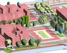
How does 3D city modelling fit within the context of broader developments such as smart cities and digital twins? And which six challenges must be overcome before 3D data as a platform becomes a reali...
Cartography is about describing the world in the form of maps and diagrams. Classic cartography produces paper maps but nowadays this field also encompasses Geographical Information Systems and the products produced by these systems. Cartography is heavily dependent on data from Remote sensing and Land surveying and topography for the dry part of our world and marine surveying and bathymetry for the wet parts of our world.
Cartography / GIS can be found in almost any industry vertical where it transforms the various data sources into products readily useable in for example land and water management, climate and farming and conservation.
How does 3D city modelling fit within the context of broader developments such as smart cities and digital twins? And which six challenges must be overcome before 3D data as a platform becomes a reali...
Accurate geoinformation about urban areas, public buildings or historical sites is in great demand. It has become astonishingly easy to capture these scenes through cameras or laser scanning or to acq...
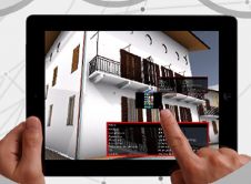
In the construction industry, business relationships are often short term and one-off. There are many unique processes and activities. The resulting complexity and fragmentation may obstruct quick and...

This interactive pass map uses techniques from geoinformation science to highlight passing patterns in a new and innovative way. The visual exploration and analysis of passing patterns helps professio...
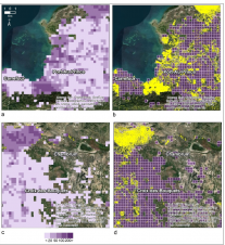
In a project in Haiti, several remotely sensed indicators were assessed to predict the completeness of Open Street Map for use in disaster relief and to guide future mapping efforts. Timely informatio...
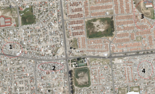
Due to the local region’s proneness to occasional wildfires, the Geomatics Division at the University of Cape Town, South Africa, has conducted research and project work around the theme of 3D reco...

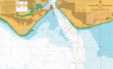
Denmark has challenging seascapes to map and chart. It has a rich history of nautical charting that dates back to the seventeenth century, and many of its navigational products for Greenland were crea...

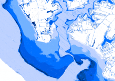
Hydrographic Offices (HOs) have realized that bathymetric data is not sufficiently represented in Electronic Navigational Charts (ENCs). A few aspects of this topic have already been touched upon in t...
Digital marine mapping became possible with the arrival of the electronic chart. The authors, who pioneered the re-engineering of this data for use in GIS, question whether the requirement has been fu...
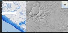
The remarkable capabilities of airborne Lidar continue to improve, with scanners now able to emit more than a million pulses every second. Although it has never been easier to acquire high-quality las...
The remarkable capabilities of airborne Lidar continue to improve, with scanners now able to emit more than a million pulses every second. Although it has never been easier to acquire high-quality las...
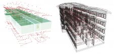
In a system termed 'historical BIM', building information modelling (BIM) is becoming a useful approach in the documentation and enhancement of historical structures. It is not easy to convert point c...

Every year, OGC runs a research, development, and prototyping initiative called a ‘Testbed,’ the most recent of which - Testbed 13 - wrapped up last December. OGC Testbeds are a key activity of th...
Digitalisation and new technologies with the ability to revolutionise the geospatial industry are creating a new playing field for mapping and surveying professionals. This evolving landscape is also ...

It used to take Questar Gas inspectors half an hour to collect pipeline assets on a site and then eight weeks to produce a final map of the work. Today, using GNSS technology, data collection takes 10...
This site uses cookies. By continuing to use this website, you agree to our Cookies Policy. Agree