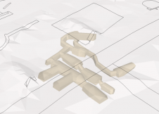
Automated Map Generalisation
Nowadays spatial information is much more often displayed on digital devices than on a paper map. Within digital environments, users have high expectations regarding up-to-date information and consist...
Cartography is about describing the world in the form of maps and diagrams. Classic cartography produces paper maps but nowadays this field also encompasses Geographical Information Systems and the products produced by these systems. Cartography is heavily dependent on data from Remote sensing and Land surveying and topography for the dry part of our world and marine surveying and bathymetry for the wet parts of our world.
Cartography / GIS can be found in almost any industry vertical where it transforms the various data sources into products readily useable in for example land and water management, climate and farming and conservation.

Nowadays spatial information is much more often displayed on digital devices than on a paper map. Within digital environments, users have high expectations regarding up-to-date information and consist...

In 2005, Blom Aerofilms became the licensed franchise operator of Pictometry oblique aerial imaging technology in Europe. The planned image collection in 15 countries, however, was hampered by the ina...
Bentley is offering a new software environment for managing spatial data, saying "Unlike a GIS, which requires data to adhere to a strict relational data model, Geospatial Management gives spatial con...
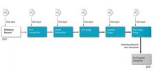
As William Pollard said, "Information is a source of learning. But unless it is organised, processed, and available to the right people in a format for decision making, it is a burden, not a benefit."...

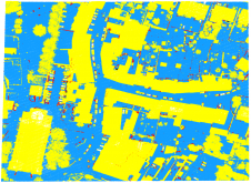
The technology push behind emerging automated feature identification and line generation techniques provides a new opportunity for the domain of fit-for-purpose land administration. It could help to f...
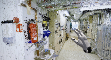
As a division of machine learning, deep learning (DL) has been achieving unparalleled success in image processing and recently demonstrated huge potential for point cloud analysis. Precise ground surf...

ICT advancements have driven progress in many aspects of geomatics, such as 3D documentation and modelling. This article explores how contemporary digital technologies contribute to the conservation o...
Geo-information technology, in particular photogrammetry, digital elevation models, ground-penetrating radar, GIS and 3D modelling, was used to document the recently discovered Baptism area in Jordan ...

Advances in capturing techniques such as laser scanning and photogrammetry have significantly increased the volume of geospatial datasets. Big geodata has become an important asset for analysis and de...
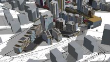
A geographic information system (GIS) has been used in the construction of a large-scale model of a smart city project in France. The smart city concept is developing very quickly around the world, be...
As 3D models are becoming common geospatial data assets for cities around the world, a recent study reviewed major 3D city modelling activities in Finland. 3D city models can be utilized for tasks inc...

Around 2003, the U.S. intelligence and defense communities forced together remote sensing and imagery analysis with mapping and charting to create the National Imagery and Mapping Agency (NIMA). Thoug...
How can the dense point clouds that originate from 3D mapping be turned into useful game engine scenes? This article considers issues including point classification and segmentation, geometric accurac...
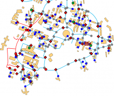
The urbanization trend is leading to an increasing number of people living in cities, thus also placing new demands on cadastral registration. To be able to register the complex infrastructures and bu...

In 2017 Dr Christiaan Lemmen, a former contributing editor of 'GIM International', was appointed as professor of land administration modelling at Twente University’s Faculty ITC for Geo-Information ...
This site uses cookies. By continuing to use this website, you agree to our Cookies Policy. Agree