
Complementary and Consistent: Duo of Trimble MX50 and X7 Saves French Company Time Capturing Precise Data
By capturing data with a combination of two Trimble solutions, Neocapture, a young French topography company, successfully and efficiently completed a data acquisition project requiring perfect consistency between point clouds recorded by static scan and mobile scan.
Located near Lyon International Airport, Neocapture, founded in September 2021, provides topographic plans, network plans and models works for a varied clientele: local authorities, construction companies, networks and roads concessionaires, topographic service providers. “Our main activity is the acquisition of high-performance geospatial data in dynamic and static 3D scanning as well as the sharing of this data with innovative tools,” says Luc Coustau, president.
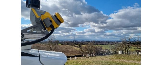
“I started surveying in 1990 and I always had the opportunity to use Trimble equipment. At Neocapture, it’s a strong need for efficiency, with increasingly tighter deadlines, that motivated us to invest in Trimble solutions. To this end, we have chosen the Trimble® MX50 mobile mapping system because we were looking for dynamic 3D scanning system that was light and quick to implement. It also needed to feature an integrated software suite, ranging from trajectory calculation to the generation of point clouds and 360° panoramic views, up to registration and automatic extraction tools. For this project, we mounted it on a vehicle and used this configuration for more than 1,500 km. In our opinion, it is currently the system with the best lightness-performance-accuracy compromise.”
Guaranteed efficiency, even on difficult terrain
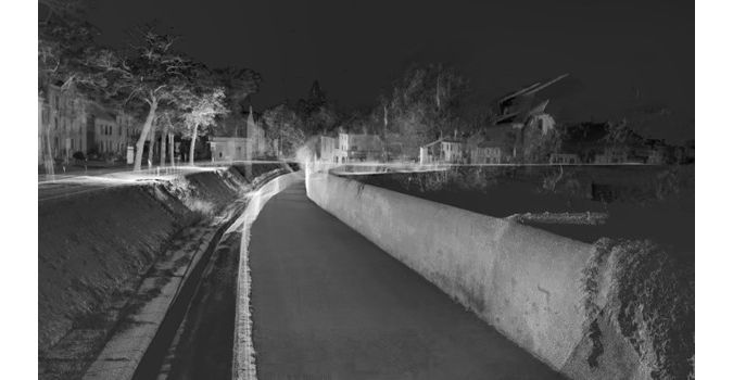
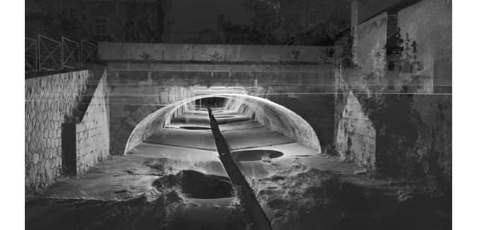
The most recent use of Trimble equipment this year by Neocapture concerns a public contract for which it was necessary to acquire data from several tens of kilometers of public roads on behalf of a Community of Municipalities. The aim: to conduct studies for the creation of a cycle path and to carry out, in the city center, the renovation of an open-air canal of approximately 1.5 km in length. For the latter, data capture was particularly tricky, as it involved many interactions with public roads, such as crossings structures, quays, tops of high and low walls, fences and guardrails.
"One of the deliverables being the LiDAR data, the point clouds produced statically with the Trimble X7 3D scanner,” Coustau says, “and those created on the move with the Trimble MX50 system had to be perfectly consistent with each other.”
For the survey of urban roads, the Trimble MX50 was installed on the roof of a car, while the Trimble X7 was used for surveying the canal, in three sections of about 500 meters, each of them consisting of about 25 scanning stations. The trajectography provided by the MX50 is calculated by the Applanix POSPac MMS software, and the point clouds are generated, colorized, checked and if necessary registered on GCPs (Ground Control Points) on the Trimble Business Center (TBC) software.
Optimal matching between different point clouds
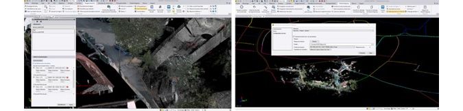
Data from the Trimble X7 was assembled in the field using Trimble Perspective software, with no target between scans. By avoiding field returns, this step saves time. This data was then controlled and georeferenced in the office using Trimble RealworksTM and exported as .Las files. “We import these files into the TBC project where those of the Trimble MX50 are located, within the projection system requested by the client,” says Coustau. “The data from the Trimble X7 formed three georeferenced point clouds (about 500 meters), whose stations are perfectly assembled together,” he says. “To match these point clouds, without deformation, with a cloud generated by the Trimble MX50 (which is in conformal conical projection), we are looking for remarkable points that the two point clouds have in common. Then we create control points (with TBC's CAD tools) on the Trimble MX50 data, which are used to re-georeference the Trimble X7 clouds under TBC and thus perfectly match the clouds to each other.”
Remarkable speed of implementation and processing
The following efficiencies were observed on the project where the required accuracy was 2 cm:
- Half a day of acquisition with the Trimble MX50 on the urban roads,
- One day of setting up topographic points used for control and resetting (angles of white horizontal signaling strips),
- One day of Trimble X7 scan acquisition for the canal,
- Three days of total processing in the office.
The main advantages were the speed of implementation and data processing provided by the MX50 and the X7, thanks to the integrated tools. Coustau noted that the X7 is easy to use, especially for employees who are already experienced with static scanning. The solution has been designed to use Trimble Perspective software in the field, which allows the assembly of clouds and the visualization of in situ acquisition. The MX50 system and TMI acquisition software worked well together.
Perfectly complementary hardware and software solutions
“We use both Trimble systems to produce raw data (point clouds) with the highest possible quality (colorized, classified and cleaned point clouds),” Coustau says. “We are increasingly sharing these point clouds with end users through the Geocassini platform. It’s 100% web, accessible in Saas mode, allows online visualization as well as digitization directly on the cloud or the import-export of existing data (DXF, SHP, etc.) and directly in the cloud for control and modification. We also use TBC for the digitization and automatic extraction of elements (such as poles) then we export in DXF (Drawing eXchange Format) files to finalize the deliverables in our CAD tools.”
The deliverables provided by Neocapture were either classic topographic plans, modeling, or raw data (the colorized point cloud), shared on the Geocassini platform. In the light of his experience, Coustau recommends using Trimble solutions on similar projects “for reasons of ease of use (interoperable software suite, easy-to-implement systems) and speed of implementation”.