Visual Positioning Technology is a Major Breakthrough in GNSS Receiver Development
The GNSS Receiver has evolved over the years. Through continuous product improvements, a highly integrated RTK receiver with inertial navigation and multi-constellation is nothing new. While RTK receiver is constantly being improved in terms of better results, mapping users still face many bottleneck scenarios where traditional ways are not easy to complete.
As it stands, a typical GNSS receiver needs to search for satellite signals in an open environment to achieve high accuracy measurements. The position of the point can only be measured if the GNSS RTK receiver has access to the open sky and the rod tip actually touches the point. Otherwise, a number of different auxiliary methods need to be performed to measure the exact position. Measuring targets with a lot of details, targets in hazardous areas, and targets with too much ambient occlusion are all big challenges that traditional GNSS receivers have not yet solved. Breaking through the limitations of measurement scenarios is a key research priority for the development of innovative GNSS receiver technology.
New Technology Application
In an era where computer technology is so advanced and sensing technologies such as AR and UAV have gained widespread attention in society, especially, in the surveying and mapping industry, staying in the high-tech technology industry, Hi-Target continues to focus on emerging technologies that can empower high-precision measurement instruments. The GNSS Receiver with visual positioning technology was born. vRTK adopts the technology of UAV oblique photogrammetry and can achieve a full range of image processing, but compared with the UAV image measurement, visual RTK surveying can be operated at ground level with more ground details that can not be measured by the UAV. It is free from height restrictions but maintains accuracy and more details, realizing fine management.

|

|
New Product Arrives
What will blow your mind is the vRTK with cutting-edge technology. Such a Hi-Target pocket-sized vRTK Receiver is a ground-breaking product that has been prepared carefully over many years. Accordingly, it is a high-precision measuring solution that realizes long distance non-direct contact and guarantees the safety of personnel and data accuracy.
Making Surveying Easier and Easier
Keeping the Sword Sharp Comes from Sharpening It
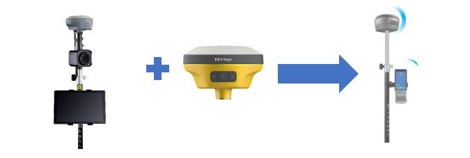
Hi-Target, as the industry leader, has long been aware of the drawbacks of user experience. In 2016, Hi-Target began the research of visual RTK and launched the first visual GNSS receiver combination type products, including receiver + professional-grade camera + tablet for 3D image processing. Although this product can offer better results, the complex combination form is not widely accepted. With the successful launch of the V200 RTK Receiver, we have miniaturized the RTK Receiver and added new image positioning technology. We also upgrade the hardware to create a multi-functional product designed from the customer's perspective. There is no doubt that it is time to open up a whole new world of non-contact measurement.
The Enriched Performance of vRTK
Multi-Protocol Built-In Radio
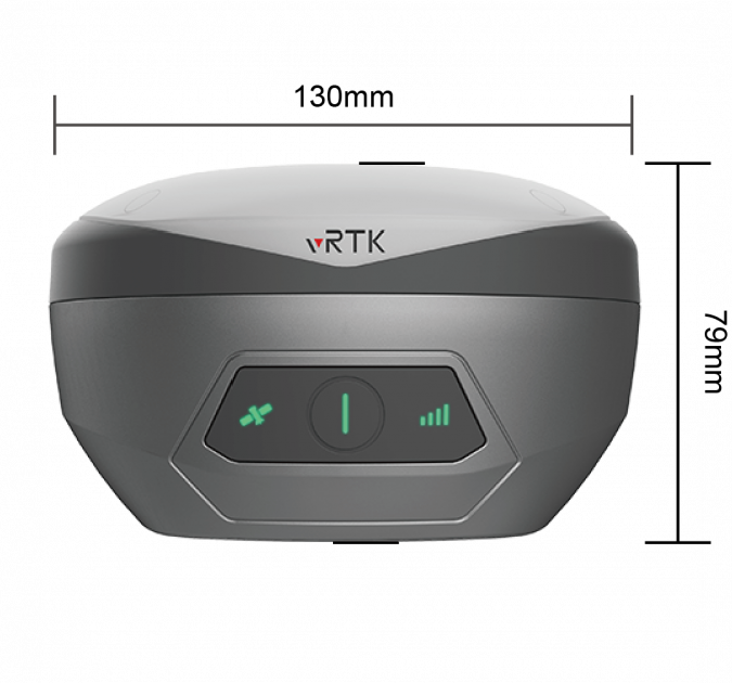
vRTK has all the premium features of the V200 with the extra value of visual positioning technology. Moreover, it includes a new motherboard and an upgraded IMU model. Like any other GNSS sensor from Hi-Target, vRTK can use RTK corrections from all GNSS correction services. With the addition of cameras, the vRTK receiver still retains a pocket size. It only weighs 970g including a built-in 6900mAh battery. With continuously operating for 15 hours in rover mode, it satisfies the user's needs for full-day work. The built-in Hi-Target multi-protocol UHF modem is capable of transmitting and receiving multiple brands of RTK radio power conditioning with a typical operating range of 7km.
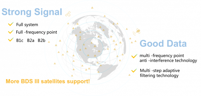
Strong Signal and High-Quality Data
A new generation of GNSS engine supports the new frequency points B1C, B2a, and B2b RTK decoding of the Beidou-3 satellite. The introduction of multi-frequency anti-jamming technology and multi-step adaptive filtering technology features strong signal, high-quality data, fast fix, and high accuracy.
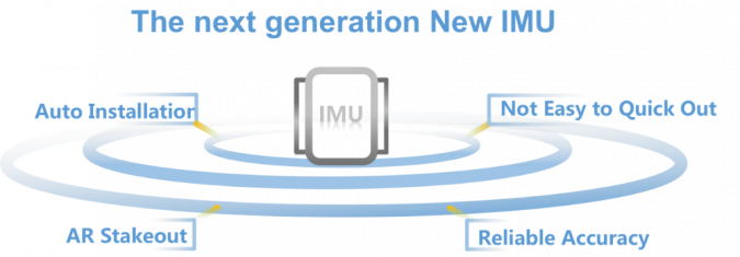
Advanced IMU Module
The vRTK adopts an upgraded 9-axis IMU module which has auto installation for the tilt survey. Users just easily pick it up and arrive at the target point to carry out the tilt survey. Ideally, the error is less than 2.5cm within a 60° inclination. It improves the efficiency of the work a lot. The users no longer have to undertake tedious preparation steps before the tilt survey.
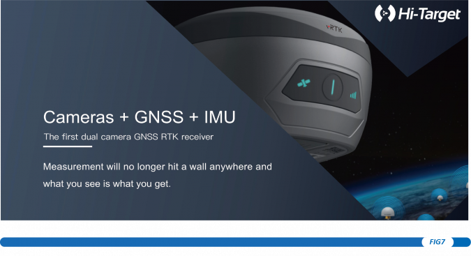
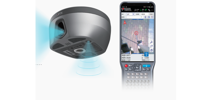
vRTK: Innovative Integration of Vision and Surveying
vRTK is suitable for non-contact measurements in a variety of hazardous and complex environments. High-quality sensors ensure the stability of the receiver's accuracy in working status. By combining imagery with high-precision positioning equipment, users will benefit from the convenience of visual positioning technology, which allows them to obtain the location of the target simply with a touch of finger from a distance. The image data with location information can unlock more usage scenarios so that measurements will no longer encounter barriers. What you see is what you get.
Image Survey
Firstly, the new image survey function achieves non-contact measurement. Consequently, it greatly enhances the available range of GNSS and efficient, safe operation. Based on Android's high-performance image processing technology, the 5MP camera for the rear view combined with the controller can obtain precise coordinates in real time, at distances of 2-15 meters, with an accuracy of 2-4 cm.
What Are the Working Scenarios?
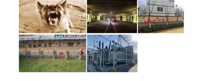
The image survey of vRTK is available in the following scenarios where traditional GNSS receivers could not work. It allows for better measurement results.
- Scenes contain a lot of details.
- Remote areas, such as deserts, cliffs, ravines, etc.
- Dangerous scenes such as busy roadways, accident scenes, or hazardous areas (e.g. risk of a dog attack and dangerous utilities.)
- Areas with GNSS signal obstructions such as under the roofs and trees.
- Target points on building facades such as the corners of windows and the roofs.
- Measuring other points without revisiting the site.
- 3D modelling of cities through surveying.
- Integrated surveying projects for premises.
Chiefly, for the domestic situation, the official projects on cadastral measurement are the key platform for vRTK to play its advantages. With the promotion of our government's integrated rural premises measurement project, carrying out integrated rural premises measurement is an important element of real estate surveying and mapping at this stage. UAV oblique photogrammetry technology provides a new means and method for integrated rural premises measurement, which has the advantages of high efficiency, low field workload, and low cost compared with traditional cadastral and property measurement methods.
AR Live-View Stakeout
Besides, the AR live-view stakeout is a new upgrade of the AR stakeout function in the Hi-survey software. In the past, the AR stakeout would merely show 3D animation for the direction and distance after approaching the target. However, when the surveyor approaches the stakeout point holding the latest vRTK with the AR stakeout function, the screen of the controller will change to the view from the camera at the bottom of the vRTK. The 2MP camera beneath enables AR live-view stakeout with an accuracy of 2cm. It saves time and effort in reaching the stakeout point.
3.3 Compatibility with 3D Modelling Software
The different types of data results obtained from vRTK are compatible with third-party data processing software. It meets the needs of different industry applications. Moreover, vRTK is newly compatible with mainstream modeling software, making 3D modeling as simple as possible. At the same time, the image data by vRTK will be an excellent tool to compensate for the inability of aerial image surveying to measure feature details. Combining the image data from UAV and vRTK, the whole effect in 3D software will be more complete and detailed, which absolutely will be a piece of great news for engineering users.
Measure What You See at Your Convenience
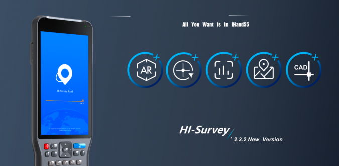
Last but not least, as an innovative and highly anticipated product, the vRTK will be launched with Hi-Target's new large screen controller iHand55, both of which are extremely light and portable while providing a long battery life to ensure that users can easily and efficiently complete surveying tasks in fieldwork.
Hi-Survey will also be the perfect partner for surveyors working outdoors with vRTK. The new Hi-Survey software is to optimize the efficiency of the image survey and AR live-view stakeout. It allows users to use them very smoothly. In addition, the new CAD drawing function supports user-defined CAD drawing and easier operation for faster import and precise capture.
The launch of vRTK is a new milestone in the development of GNSS receivers, which not only breaks through the limitations but also greatly improves efficiency and accuracy. It combines several innovative technologies in a pocket-sized receiver, fully reflecting the highest degree of Hi-Target's GNSS receiver. Hi-Target focuses on creating more user-friendly products in the clients’ best interest. Furthermore,the team keeps developing GNSS Receiver as the best tool for surveying work.