
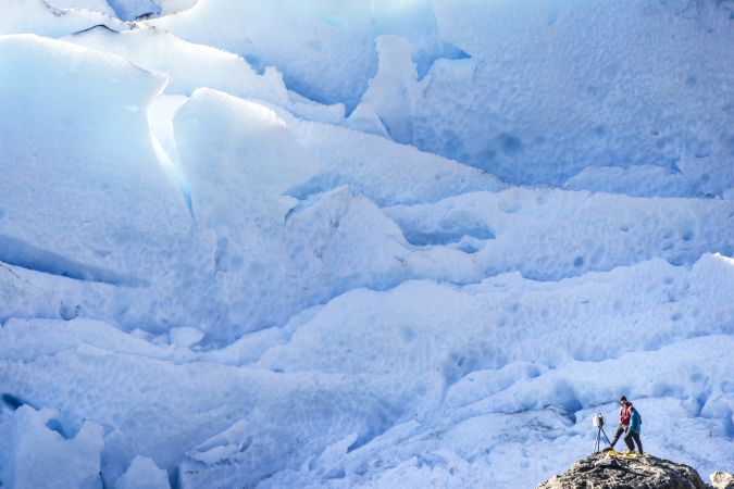
“Look deep into nature, and then you will understand everything better,” Albert Einstein is quoted as saying. And indeed, looking deep into glaciers can help us understand climate change. But glacier exploration is notoriously treacherous. Even where meltwaters and landforms create openings and caverns in the ice, these can be inaccessible due to the risk of collapse and falling blocks of ice. Nonetheless, many fundamental physical and biological processes operate in caves and crevices in glacial ice, making them a challenging but fruitful area of study. A team of scientists and surveyors set out on an expedition to a Patagonian glacier to collect data on ice flow and dynamics. They integrated several 3D laser scanning instruments and techniques: terrestrial laser scanning (TLS), unmanned aerial vehicle (UAV or ‘drone’) photogrammetry surveys and a GNSS smart antenna.

Technological advancements have brought increasingly compact instruments, enabling more rapid data acquisition and powerful processing abilities even in extreme field environments like glaciers, according to Tommaso Santagata, surveyor and speleologist from VIGEA – Virtual Geographic Agency and part of the Patagonia team. “Terrestrial laser scanning can give us a lot of information that we can merge, for example, with satellite data, to better understand the velocity of the movement of the glaciers and changes happening on the surface of the glaciers. The idea is also to better understand how these changes provoke other changes, in the caves and in the environment near the glaciers, because it’s all connected.”
The spectacular sight of the Perito Moreno glacier in Argentina’s Los Glaciares National Park attracts nearly 100,000 tourists each year. The Perito Moreno is one of 48 glaciers fed by the South Patagonia icefield, an ice mass covering more than 250km2 and extending more than 30km east. At its front, the Perito Moreno cuts through the Brazo Rico arm of Lake Argentino, forming a natural dam. Unusually in the context of global warming and climate change – and setting this glacier apart from others in the region – the ice mass of the Perito Moreno glacier was relatively stable during the last half century. Scientists have therefore looked to it for insights about how glaciers might respond to future climate change.
The Expedition
In March 2017, a team organized by the Italian La Venta Esplorazioni Geografiche and the French Spélé’Ice, in collaboration with Leica Geosystems – part of Hexagon – and several academic partners, set out to study the Perito Moreno glacier. Expedition members and project researchers sought to learn more about the micro flora and fauna inhabiting the glacier and gain a better understanding of ice dynamics and the speed of glacial melting.
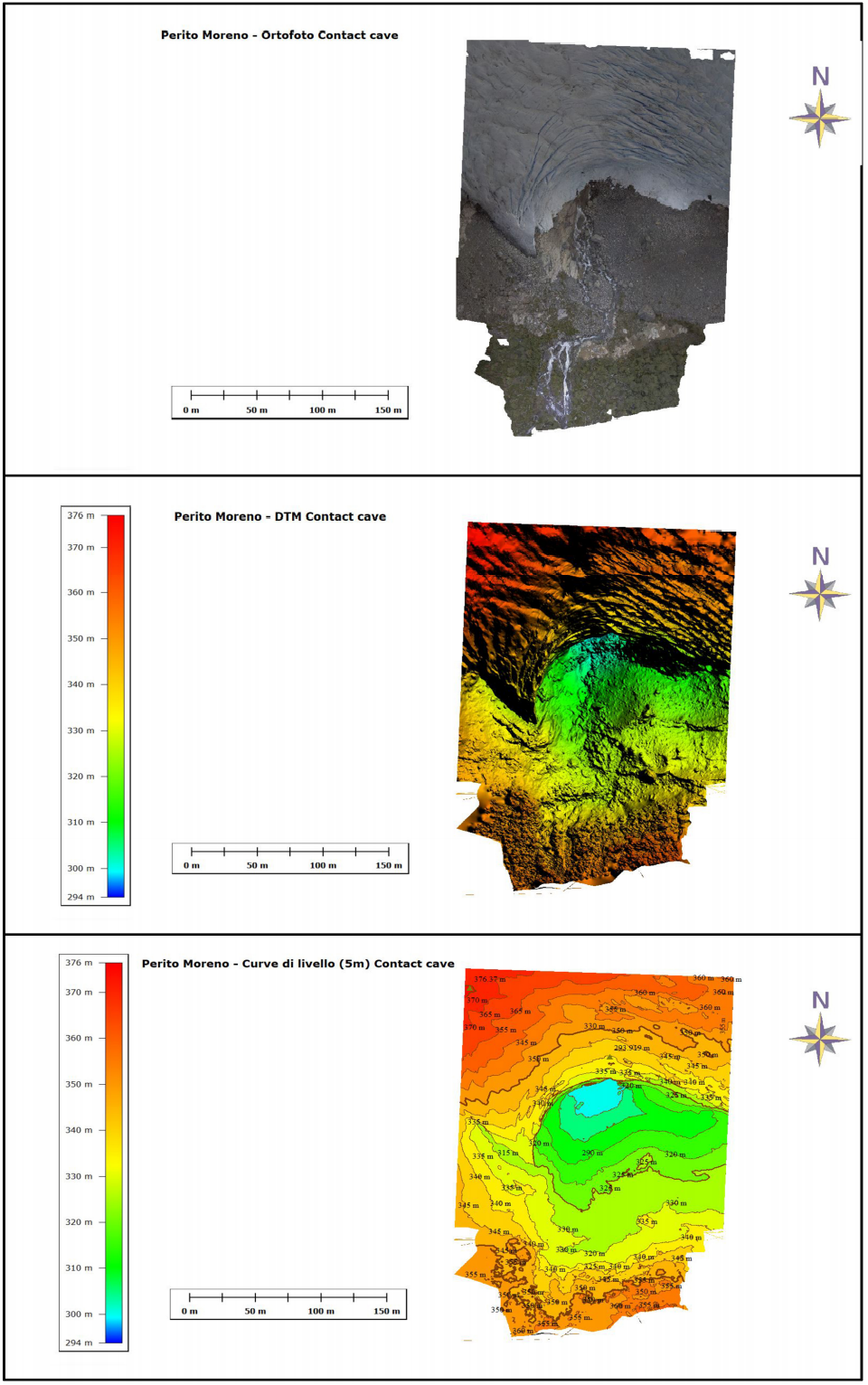
The team also wanted to investigate and map at least one glacier cave. For this, an opening at the base of the glacier, carved out by a feeding stream, provided a worthwhile study object. As the cave was too dangerous to explore on foot, laser scanning and UAV photogrammetric surveys were carried out from a safe distance to map a 50-60m segment of the interior of the cave and the area surrounding the cave entrance.
Video courtesy: Martino Frova - La Venta.
The Technologies
The Patagonia expedition provides yet another example of how new instruments and technologies, in this case laser scanning and UAV photogrammetry, are revolutionizing geographic surveying. “These techniques are increasingly used in geological studies, such as in caves or for the calculation of ice surfaces and changes in ice volumes,” says Santagata. “3D laser scanning technologies can acquire millions of points represented by 3D coordinates, at very high spatial densities on complex multifaceted surfaces within minutes. The dense point clouds contain a huge amount of data that can be used for representation and analysis.”
On the Perito Moreno expedition, the team used a Leica ScanStation P40, which captures high-quality 3D data and high-dynamic range (HDR) imaging at a distance of up to 270m. The laser scanner was controlled using a Leica CS35 tablet computer, which also enabled team members to verify the partially processed data while still in the field. “It’s very easy to process the data immediately,” comments Santagata. “It’s fantastic that in the field you can see right away if you have obtained all the data.”
Eight Scans in Two Hours
Eight laser scans were performed in an operation that took about two hours, working in the late afternoon to avoid direct sunlight. The camera integrated into the laser scanner was used to produce coloured point clouds and take 360° panoramic images. Two UAV photogrammetry flights were carried out, at 30-70m altitude. These produced some 120 georeferenced photographs in DNG file format.
To get a sense of the daily movement and ablation of the ice, the team used a Leica Viva GS16. This is a ‘self-learning’ GNSS smart antenna, meaning that the instrument is designed to distinguish strong signals from weak or noisy signals and to hone in on only those signals that provide the best performance. The GNSS smart antenna was used both to obtain measurements for ground control points for the UAV photogrammetry survey and to determine velocity and elevation changes along a north-south strip of the glacier. By pairing the instrument with the CS35 tablet computer, the team could again verify and partially process the data directly in the field. The set-up enabled measurement of the speed of ice flow both at the edges and in the centre of the glacier and observations of changes in glacier surface morphology over the four days of the fieldwork. “The changes are remarkable, even in this short period of time!” one expedition member marvelled.
Visualizing the Data in an Interactive 3D Model
To align the point clouds and create a 3D model, the survey team used Leica Cyclone point cloud processing software. The model was then processed further with Leica Cyclone 3DR to obtain several kinds of outputs and elaborations from the laser scanning and photogrammetry data. Cyclone 3DR handles most industry-standard formats, so the team could merge the laser scanning data with images taken by the UAV to create the model. To share the 3D data with colleagues outside the team, they used Leica Geosystems’ free JetStream Viewer. This allows anyone – even those without 3D modelling experience – to easily view and manipulate point clouds.
Good Science
As global warming and climate change progress, key questions for the scientific community are how much and how quickly the glaciers will melt and what that means for life on Earth. One thing we know with certainty is that geomatics will be essential in finding answers.
The Perito Moreno expedition marks a new line in a tradition of exploration dating back to prominent 19th-century Argentinian explorer and academic Francisco Moreno, after whom the Perito Moreno glacier is named. Experts who have studied glaciers for decades have witnessed the startling speed of glacier thinning and retreat. The Perito Moreno has been relatively stable in terms of ice mass, which makes it an anomaly. But this glacier, too, is thinning. Glaciers here are retreating at an unprecedented rate, with some at low altitudes expected to disappear completely within the next 25 years. This process contributes significantly to sea level rise and raises questions about the sustainability of urban freshwater supplies, agriculture and the future of hydroelectricity in the region, as these often depend on glacial or snow run-off.
Compact and powerful data collection instruments and techniques, as well as intuitive data processing solutions that can be accessed in the field, enabled this expedition to bring home an abundance of data and information for analysis – an accurate record from which to measure further changes in the ice and to create 3D models for divulgation purposes.
Inspiring and Educating
The project outputs are already inspiring and educating the next generation of professionals. Following the expedition, 360° photographs from the 3D models and an interactive 3D model were produced. Visitors to the International Speleological Meeting in Sardinia, Italy, in 2019 could explore the model through virtual reality glasses, for a more visceral experience of the glacier’s interior relief. The 3D model is now publicly available online.
It is important to note that the 3D laser scanning of the cave was not a primary objective of this expedition. The opportunity to have these technologies and instruments in the field, in the right place at the right time, allowed their use to obtain this important data collection. The data can now be applied for comparisons, to better understand future changes of this part of the glacier. That is a worthwhile goal for the future.
Organizations involved in the project
Los Glaciares National Park, La Venta, Spélé’Ice, University of Milan-Bicocca, Natural History Museum of Paris, Paris Diderot University, University of Florence, University of Bologna, VIGEA – Virtual Geographic Agency, and Leica Geosystems – part of Hexagon.
Disciplinary cross-fertilization
A primary objective of the Patagonia expedition was to collect microorganism samples from cryoconites, which are grey powdery deposits on glaciers. Due to their darker colour, they form holes on the ice surface, creating spaces where micro ecosystems can develop. Using photogrammetry, VIGEA’s Tommaso Santagata created a 3D model of the main cryoconites sampled by the team’s biologists, demonstrating the value of having multifunctional and manageable instruments in the field.