
Drone surveying is a lot more complicated than snapping an aerial photograph or two and calling it a day. You need to be sure your images can be scaled properly with each other and aren’t distorted. On a job where being off by only a few inches can have a great impact on your work, getting it right matters.
One way to ensure image quality and remove many of the challenges that come with image perspective is by taking orthomosaic images of a site. This technique can be used to make incredibly detailed maps. However, given cost constraints, they are truly best for only certain jobs. Read on to discover how orthomosaic mapping can be used to help you to up your drone surveying (or other UAV work) game.
What is an orthomosaic image?
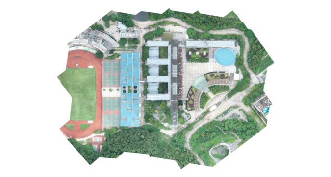
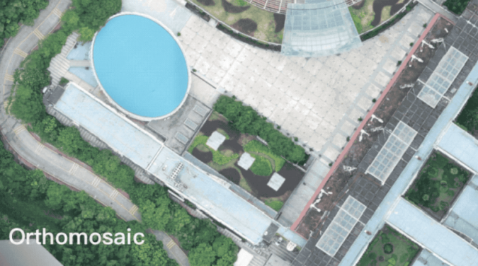
An orthomosaic image, also sometimes known as an orthoimage, orthophoto or orthophotograph, is a high-resolution aerial image taken by a UAV. When stitched together with specialized software using a process called orthorectification, these images can be used to create a highly detailed, distortion-free map – and enhance the visibility of details that may not be visible using more common photogrammetry techniques. Orthorectification removes perspective from each individual image to create consistency across the entire map while keeping the same level of detail from the original image.
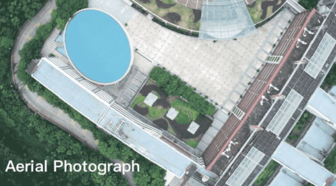
Orthorectified imagery differs from standard aerial photographs in the way that it visualizes perspective. Orthophotos are corrected for perspective, camera tilt and lens distortion. Doing so means that these photographs can be scaled accurately from image to image, making for surveying measurements you can trust for true distances. That being said, you’ll still need to use standard drone land surveying techniques like ground control points and calculating ground sample distance.
Turning orthomosaic images into orthomosaic maps
It’s important to note that a single orthophoto image will appear distorted and not offer the kinds of benefits you’d expect from the finished product. Each aerial photo is taken from a slightly different perspective and is not valuable on its own. Rather, the image collection must be orthorectified together – with different camera angles and topographic changes accounted for and corrected for – to make one consistent map. One of the easiest ways to ensure this consistency is by using software that automates your drone’s flight path and a payload that can take photographs at precisely the right times and angles.
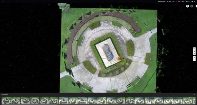
In addition to using an automated flight path, you’ll need drone mapping software with orthomosaic capabilities, such as DJI Terra. With Terra you can generate a 2D orthomosaic of a set area in real time – making it the ideal software for time-sensitive projects. The software also performs 2D reconstructions that are rapid and accurate. Other capabilities include 3D mapping and reconstruction, Lidar processing and data analysis.
Orthomosaic images in surveying
Orthomosaic maps offer several advantages over regular aerial photos – however, a super high-quality image may not be necessary for every surveying job, especially considering the potentially higher price point. Orthomosaic maps are valuable for surveyors because they lack distortion and aren’t impacted by factors like perspective. They’re also easy to turn into interactive 3D assets. For worksites that require scalable maps with consistent details throughout, the orthomosaic option is simply unmatched.
Orthomosaic mapping does have its drawbacks. The modelling style requires far more close-up images, requiring you to fly your drone closer to the ground. This may take more time than other methods. In addition, the kind of image detail that is the trademark of orthomosaic mapping sometimes isn’t necessary. For example, if you are only trying to determine the boundary of a piece of land or only need detailed imaging of a specific area, an orthomosaic map will probably offer very little.
Other uses for orthomosaic maps
Surveying isn’t the only sector that can benefit from the use of orthoimages. Some of the most common sectors making use of ortho maps include:
- Farming: Taking multiple orthoimages over time can allow farmers to spot patterns in how their crops are growing over time. This is especially important for monitoring crop health.
- Law enforcement: Police officers and firefighters use UAV mapping to map out busy areas and crime scenes. With their higher level of detail, ortho maps may be able to capture important details that would otherwise be missed.
- Real estate: Orthomosaic maps of properties can be turned into interactive virtual tours. This feature was especially important at the height of the COVID-19 pandemic when in-person property tours were limited.
- Environmental conservation: Conservationists can utilize an orthomosaic photo to spot endangered animals in a set land parameter or capture change over time.
Across the board, orthoimages and maps are useful for both detailed imaging and topographic accuracy. Whether you’re looking to use orthomosaic imaging for land surveying or one of its other wide-ranging applications, DJI has the ideal drones, camera payloads and software for the job. For more information about DJI Terra and the best drones and payloads for any surveying challenge, go to https://www.dji.com/.