
A national mapping agency in Europe needed to create a 3D digital twin of its entire country from a collection of geospatial data in varying scales and formats. A primary goal of the project was to build a repeatable, automated workflow to rapidly produce new digital twins in the future to identify and visualize changes in infrastructure and terrain resulting from unexpected events, either natural or man-made.
The project was complex, with several additional key objectives outlined by the agency:
- The automated workflow had to generate a nationwide digital twin in 72 hours or less.
- The digital twin had to be created in an open-source Open Geospatial Consortium Common Database (OGC CDB) format to support application of advanced computer simulations for training and preparation purposes.
- The initial workflow had to determine whether readily available open-source vector data or high-resolution satellite imagery should be used to ensure production of the most accurate 3D digital twin possible.
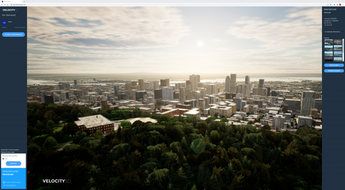
The agency contracted Presagis of Montreal, Canada, to build the repeatable workflow, generate the nationwide digital twin, and perform the requested analyses using its VELOCITY 5D (V5D) cloud-based platform. Leveraging its decades of experience producing high-fidelity 3D environments for GEOINT, defence, and security applications, Presagis developed V5D specifically to build 3D digital twins from diverse 2D geospatial datasets for the purposes of visualization and simulation.
Multiple, Diverse Source Datasets
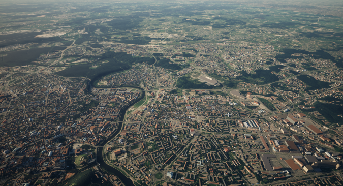
As is true for many national mapping agencies, the client in this project had accumulated GIS vector layers, satellite imagery, and terrain data, but the files were of inconsistent formats, quality, and coordinate systems. Although this agency was a sophisticated GIS user, the variety of datasets covering a land area exceeding 65,000 square kilometres presented an ongoing challenge in delivering a multitude of derivative map products to its in-country customers – much less a single seamless digital twin.
With this common challenge in mind, Presagis had developed its platform with automation from end to end, which meant the front of the ingestion process performed the data cleanup, standardization, and transformation. For this nationwide project, the mapping agency merely had to deliver its geospatial datasets to the Montreal firm for ingestion.
These datasets included nationwide 0.5m multispectral satellite imagery, 30m Shuttle Radar Tomography Mission terrain data, OpenStreetMap (OSM) vectors, and other proprietary GIS source data, all totalling 1TB in size.
Planning for the Unplanned
The 72-hour turnaround time for the digital twin creation was not an arbitrary deadline. The mapping agency determined that in the aftermath of an unplanned incident, it would need to generate a new digital twin – either for the entire country or at least a region of it – in less than three days to assess and analyse change. This information would have to be delivered to responders for informed deployment of resources following an incident.
The agency understood that a significant advantage of digital twin technology is that a new one can be analysed against the existing baseline digital twin using artificial intelligence (AI) algorithms to rapidly find post-event differences in the landscape or infrastructure. AI technology is built into the V5D platform for change detection, feature extraction, and other uses.
Throughout the generation of the nationwide digital twins, Presagis tracked the processing time required for completion of tasks.
Leveraging AI for Building Footprint Extraction
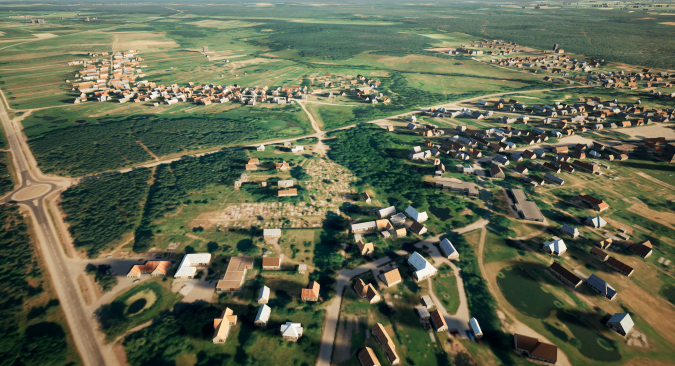
An important comparison was made during the project to determine which input datasets resulted in the best quality digital twins. The two source datasets used in the comparison were a publicly available country-wide OpenStreetMap (OSM) file and the border-to-border 0.5m multispectral satellite imagery.
The accuracy with which building footprints were derived from each dataset was used as the determining factor in judging overall digital twin quality. This was considered a reliable point of comparison because extraction of building footprints is a critical component in the generation of nearly all 3D digital twins.
The V5D platform provided the flexibility for generation of the digital twin from both the OSM and satellite image source data. In developing the platform, Presagis was aware that not every customer has access to expensive sub-meter satellite imagery covering a large geographic area, which is why it built the cloud solution to create digital twins successfully from a variety of different datasets.
The footprint extraction process leveraged proprietary embedded AI algorithms developed by Presagis specifically for automated object identification in V5D. Unique to the digital twin generation platform, this AI technique utilizes U-Net semantic segmentation architecture with dense blocks. Attention mechanism is employed to ensure important features produced from the blocks are retained and prioritized.
The results of applying the AI-based extraction technique to the provided high-resolution satellite imagery proved far superior to the automated creation of building footprints from the OSM file, which does not use AI. For the entire nation, the digital twin was generated with a total of 1,341,227 footprints from the imagery versus 1,285,799 from OSM – a difference of 55,428 footprints. Not only did the AI find significantly more buildings, it also placed their locations more accurately on the chosen digital twin coordinate system.
More importantly, the digital twin generation with the AI-satellite imagery technique required only 60.5 hours of run time versus 68 hours for the OSM process – both well within the 72 hours requested by the mapping agency. In both cases, the total time included data preparation and ingestion.
Simulation-Ready Output
For the national mapping agency, the next most important aspect of the project was the output format for the digital twin data. Since the agency already used a preferred third-party simulation software for the variety of situations and scenarios it planned to visualize with the digital twin, it requested output in the simulation-ready OGC-CDB format.
Given the fact that Presagis has its roots in the simulation world, it had developed V5D with the capability of outputting data in numerous formats for compatibility with most simulation packages on the market today. The company’s own simulation applications utilize the OGC-CDB format, so it is a default output for the platform. However, the digital twin generation software could also produce files in I3S for Esri, 3D Tiles for Cesium, and FBX for Unity or Unreal.
Producing the nationwide OGC-CDB output file took roughly seven hours for both the OSM and AI-imagery processes once the digital twin was generated.
Conclusion
Moving forward, the national mapping agency will use the 65,000-square-kilometer digital twin for multiple applications. On a routine basis, the single digital twin will serve as a central GEOINT repository from which a variety of charts and maps in 2D and 3D will be created – aeronautical, maritime, topographic, elevation models, geodesic and others. The digital twin can continually be updated with new and different types of geospatial data.
The most important application for the digital twin, however, is to assist the national mapping agency in simulating and preparing for unplanned events such as natural or man-made disasters. If such an incident occurs, the agency will likely acquire new remote sensing imagery either by satellite or aircraft to create a new digital twin for the entire nation or just a small area.
Regardless of whether the imagery is from the same sensor as that used to generate the original 3D twin, V5D can be deployed to use its AI algorithms to detect and assess damage to the landscape or infrastructure. As requested, this can be done on a nationwide scale in as little as three days or at the smaller scale of a city within a matter of hours.
Whatever the scenario and scale, the national mapping agency is now better prepared than ever to respond and safeguard its citizens.