
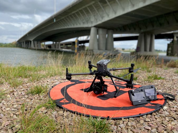
The use of a Phase One iXM-100 enabled EyeFly BV to fly closer to the Buggenum rail bridge in the Netherlands for the required annual bridge inspection. This achieved a resolution of close to 1mm ground sampling distance (GSD) and an image footprint of 12m x 9m from a flight height of 10m distance. The data has been used to create a 3D mesh of the structure.
Dutch company EyeFly BV is one of the few fully certified operators of unmanned aerial vehicles (UAVs or ‘drones’) in the Netherlands. The company has obtained all the permits regarding the commercial use of drones as well as additional certificates for flying in congested areas and controlled airspace. EyeFly is focused on performing inspections and mapping (2D and 3D models) using aircraft that have been tested by the Netherlands Aerospace Centre and registered in the aviation records.
The company offers a specialist level of expertise and skills in infrastructure, construction, geoinformation and surveying. Achieving the best possible results using EyeFly’s existing certified equipment means acquiring high-resolution cameras that are ready to integrate. The Phase One Industrial iXM-100 camera easily incorporates with the company’s DJI M600 and Freefly Alta UAVs, plus it provides close-to-1mm resolution data with a large footprint at a safe enough distance from the object to meet the safety requirements.
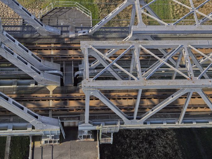
Annual maintenance inspection of Buggenum bridge
EyeFly supports Strukton Rail with the annual maintenance inspection of Buggenum rail bridge in order to identify changes in the structure from year to year. Areas of wear and damage are identified, and areas with the biggest changes are given priority for repair.
Previously, EyeFly faced the challenge of obtaining a resolution/GSD of close to 1mm while keeping the UAVs at a safe distance from the bridge. Lower-resolution sensors meant tens of thousands of images with smaller footprints had to be captured over a number of days. It was difficult if not impossible to generate a 3D mesh of the structure. Images were provided to the client using a sharing platform such as WeTransfer. There was no ability to correctly trace back every image.
Large footprint without reducing the level of detail
Remco Kootstra, director of EyeFly, explains: “We chose the iXM-100 as it easily integrates with our DJI M600 platform in combination with the IOS IX Capture application. The camera is used on both our DJI M600 and Freefly Alta UAVs. The M600 is used for capturing the top and sides of the structure and the Alta enables us to perform an inspection from the underside of the bridge because of the ability to mount the IXM-100 on top.”
EyeFly uses the RSM 35mm lens as it has a focus of 10m to ∞ while the RSM 80mm AF lens is only 30m to ∞. The 35mm lens enables the UAV to be flown closer to the bridge and achieve a resolution of nearly 1mm with an image footprint of 12m x 9m from a flight height of 10m distance from the object.
Integrated system
The system includes:
Phase One Industrial iXM-100 medium-format camera
RSM 35mm lens
RSM 80mm AF lens
DJI M600
Freefly Alta UAV
Data acquisition
Since availability of GPS is limited on the underside of the bridge, the images are captured with a large overlap so that the processing software can provide orientation parameters and position data. The iXM-100 has enabled EyeFly to significantly reduce the number of images; 5,000 100MP images were captured in two days covering the top, side and bottom of the structure.
Additionally, it is now possible to create a 3D model of the entire project on EyeFly’s web-based platform with inspection functionality. This allows clients to perform an inspection much more efficiently, without losing detail or making any compromises.
Satisfied end users
“Phase One’s 100MP camera is the best on the market and integrates very well into existing UAVs. The sensor never compromises on detail or accuracy and it always delivers. The large dynamic range means that fine details are captured, even in areas that are not well lit,” states Kootstra. “Our business has grown since we started with Phase One cameras as we are able to provide our customers with all the data that they need in one flight. The result is satisfied end users who come back time and again, as we can provide them with more details and better accuracy than we could with lower-resolution sensors,” he concludes.