
It can be difficult to get the most out of point clouds, and precise classification is a costly, labour-intensive undertaking. There should be a tool that makes it easier… and now there is, thanks to Pointly. Pointly is an intelligent, cloud-based software solution that enables the management and classification of 3D point clouds. Innovative artificial intelligence (AI) techniques enable enhanced classification through the segmentation of data points and objects within point clouds, much faster and more precisely than previously possible.
Pointly was developed by Supper & Supper, a full-service data science consultancy based in Germany that creates customized solutions for machine learning, artificial intelligence, process optimization and digital transformation for clients around the globe. Thus, one can also take advantage of the expertise of Supper & Supper through Pointly Services, where innovative, tailor-made 3D deep learning solutions are offered. The company developed Pointly in response to the need for a tool to help the geospatial field work faster and more efficiently. Shifting from a human-centred process to an autonomous workflow incorporating AI is a crucial step to help speed up inference processes and deliver greater consistency and accuracy. Pointly is set to become the secret weapon for companies across the mapping sector.
How can Pointly increase enterprise efficiency and save time and money?
Working with point cloud data for major projects typically involves complex analysis that takes considerable time and intensive work. Without the right tools, it can be difficult to extract maximum value from the point clouds and deliver results. Pointly offers easy-to-use but advanced labelling tools plus a user-friendly interface, and conversion is simple. It creates labelling efficiencies, translating into time and money savings for enterprises – and there are a lot more features on Pointly’s roadmap.
By using a software as a service (SaaS) like Pointly, processes can be streamlined and optimized, delivering results on time and with a reduced budget. This means enterprises are freed up to take on additional projects, increasing their revenue. Since it uses the highest-standard cloud-based platform on which data can be uploaded and stored, there is no need to invest in an on-premise solution, delivering further savings and unlimited scalability. The feedback was that with the approaches of Supper & Supper and Pointly, a much more cost-effective and time-effective process was achieved.
So how does Pointly work?
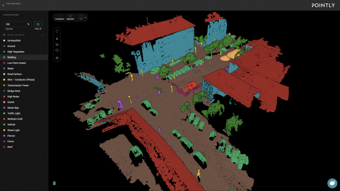
Pointly processes point clouds acquired via laser scanning, photogrammetry or other techniques, recognizing related point segments across three file-scale granularity levels: coarse, medium and fine, depending on the point cloud resolution and size of the objects of interest. This enables the selection of large areas like ground with one click, and small objects such as street signs with the next. Point clouds are available in their full resolution and will be dynamically loaded in the browser. Pointly enables toggling between three views:
- Original: displays point cloud dimensions like RGB, intensity, height profile, etc.
- Segments: shows the pre-processed segments generated by Pointly
- Transparent: can be used to hide or highlight selected classes, enabling focus on the objects that matter for the use case.
The segment selector tool allows one-click selection of segments, preventing the need for zooming, changing views or drawing the perfect border around any item. Objects with complex outlines can be quickly selected and assigned an object class, because Pointly understands the most likely breaks between objects and allows for selecting on this basis. The polygon lasso tool enables easy selection and labelling of segments, and the 3D bounding box tool controls the selection depth, enabling nuanced classification of objects that are close together or need to be separated in space. Check out this video to see Pointly in action.
The idea is that users can manually classify point clouds to continuously train the AI based on this input. This closes the gap between human labelling and machine learning so that the process of training neural networks becomes automatic and scales up rapidly. Investing time in training your AI model increases its robustness and efficiency, as the neural network learns to abstract from the training data. Pointly uses intelligent editing tools that enable training data to be generated quickly and easily. The AI takes manual and repetitive work off people’s hands so that humans can focus on what matters more to them.
Pointly is backed by Azure’s 256-bit AES encryption standard and advanced threat protection, so users can be assured that data is protected whether in storage or transit. User identity is also managed through Azure B2C, ensuring data is secure and only the user has access to their own data.
Successful use case – rapid, accurate forest inventory using Pointly
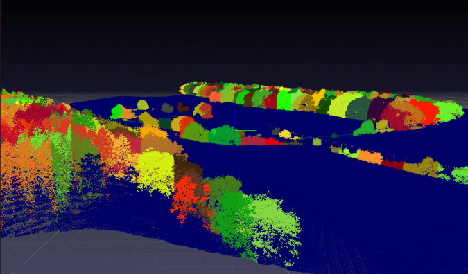
German enterprise RAG Aktiengesellschaft works on a range of environmental protection projects including mine water management, polder measures and groundwater purification. RAG Aktiengesellschaft specializes in long-term monitoring of mining damages, i.e. automatic detection of landscape changes, and here especially ground movements. To support this monitoring, a forest inventory is created, involving gathering accurate data on the health and diversity of a community forest to obtain details such as tree condition, species, size and location. Typically, extracting inventory information such as the number of trees, their canopy shape or height is very labour-intensive, since it is traditionally conducted manually, either with traditional GIS tools or even by people surveying the forest in person with a GPS. Either of these options can be a considerable undertaking for the company, thus offering great potential for automation.
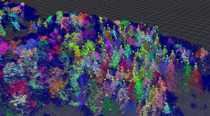
RAG Aktiengesellschaft requested Pointly to create a forest inventory by producing a tree segmentation and output a detailed map to detect where the single trees are located. Airborne Lidar scans were classified using a neural network, specifically trained for this use case to be further processed by adapted algorithms for vegetation segmentation. This enabled the information to be extracted automatically from point clouds, identifying exact tree outlines, size and location. This forest inventory was needed to isolate the causes of changes in the landscape by monitoring changes over time and observing which of them may contribute to damage to near-surface mining. The goal was to provide exact tree point identification in the point cloud as well as individual tree separation with corresponding inventory data for the object ID, the position and the crown’s extent in terms of results.
Deep learning and smart algorithms were combined to identify tree points and separate individual trees from above, both with visible tree trunks and without. The Pointly team found that developing a universal approach required testing different methods, such as watershed separation and region growing from detected tree stems. Initially, the scenes were classified manually to generate a comprehensive set of training data for the neural network. Using Pointly’s efficient classification tools, automation was set up for further processing, and this part of the work was completed within just a couple of days. Next, the full dataset was classified automatically, using the trained neural network to proceed with instance segmentation of individual trees. The segmentation was performed using a combination of tree features (such as crown maxima), tree stump positions and geospatial algorithms. Stump position and height were determined for each tree segment, whereas the crown extent was determined by means of 2D projection. Finally, the classification and instance segmentation results were transferred into GeoJSON and Esri shape files and enriched with additional information including height attributes.
With the work from Pointly, RAG Aktiengesellschaft received a detailed map layer with tree counts, positions and canopy as well as tree trunk extents. The team found that Pointly enabled them to work more efficiently in identifying and classifying objects, especially for the identification of individual trees and other relevant inventory data. Creating a streamlined process for this data results in a lot less time and reduced cost to produce the needed results. With Pointly, the generated data can reach a higher accuracy and the process becomes more agile than traditional methods would have been.
For which fields and applications can Pointly make the most impact?
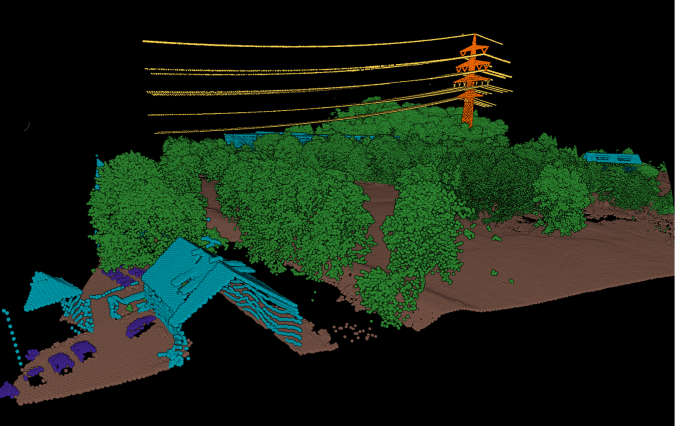
The applications for point clouds are diverse, and the potential of a 3D point cloud goes far beyond virtual site inspections. The Pointly team can develop solutions to facilitate digitalization in construction, urban and landscape planning, mining, robotics, autonomous driving, energy supply and of course forestry. They can be applied almost anywhere when prototyping and reverse engineering of 3D models is required, such as surveying construction sites or indoor mapping and modelling, as well as measuring volumes, angles, surfaces, heights, areas and distances. CAD surveyors will no longer need to undertake intensive manual work since Pointly also intends to automate this process, meaning that CAD models will be achieved in a much shorter timeframe automatically. Pointly will soon also have a feature to train customizable self-learning models which not only automate the labelling work but allow to keep improving the network every time a correction is made or more training data is added. It is this customization that offers an additional return on investment since every project is unique.
What else is next for Pointly?
At Supper & Supper, they continue to refine and expand functionality in line with client and project needs across the breadth of the field. Features under development include collaboration tools that enable sharing projects and point clouds for viewing and editing, advanced integration to import and view a range of file formats and interfaces to other platforms, as well as additional AI and conversion tools. Future offerings include standard detectors which are perfect for larger areas as they classify certain classes automatically, plus the ability to export a wide range of data products including 3D CAD models, map layers and more. Pointly will incorporate AI-based detectors for common use cases, as well as supporting analytics services that can generate high-level data products like reports, statistics and 3D models, and AI integration as a service.
Try Pointly yourself or take advantage of a new Pointly Service
There is a free account that allows you to test Pointly without any risk. Furthermore, Pointly recently came up with a new AI Training Service, where you can request an AI model trained and tested on your data to classify point clouds. If you have a point cloud classification use case that could benefit from tailor-made automatic classifications that continuously improves with your data, then this service is for you! Click here to enquire about Pointly’s new service.
Reach out to info@pointly.ai with any questions and to find out more about how you can boost your operational efficiency with Pointly.
Pointly - 3D Point Cloud Classification Made Smart, Fast, and Accessible →