
The release of Android version 7.0 in 2016 allowed users to access raw data transmitted by the Global Navigation Satellite System (GNSS) for the first time. More recently, it has become possible to receive even more raw GNSS data due to the capability of some Android mobile phones to record data at multiple frequencies and from additional satellite systems. The innovations in these domains have translated into a new source of untapped big data that can not only improve navigation but can also be applied to other scientific areas, for example to improve weather forecasting.
Tapping into New Sources of Raw GNSS Data
Location information has become an indispensable part of our daily routine, whether we use a navigation system to get from A to B, access location-based information from our mobile phones, or upload location-tagged photographs to social media. There are now many other sensors besides mobile phones that have location capabilities, for example the distributed array of the Internet of Things (IoT), sensors that underpin smart city applications and, increasingly, wearables. However, open availability of the data and the ability to receive the GNSS data in more than one frequency, which has benefits in terms of improved positional accuracy by correcting for atmospheric errors, are currently still limited.
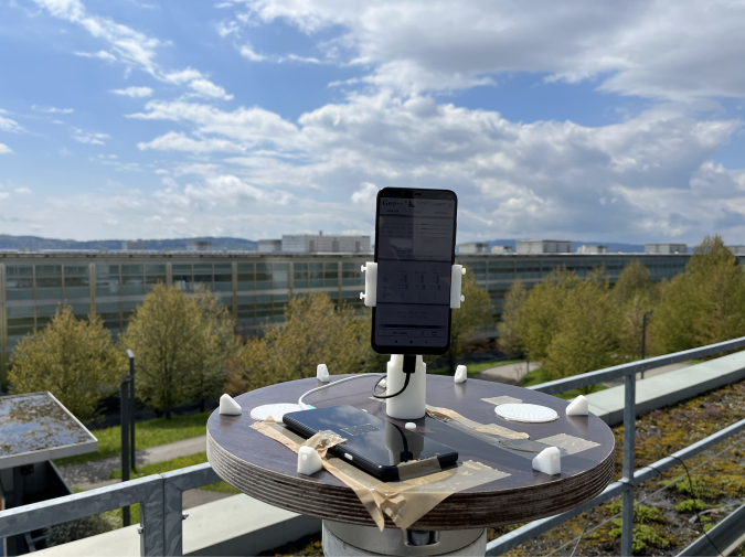
Recognizing the opportunities emerging from the possibility of acquiring GNSS data with smartphones for scientific applications that go beyond navigation led to the CAMALIOT project, which is one of two sister projects funded by the European Space Agency under their NAVISP Element 1 programme. Led by ETH Zurich, the team has demonstrated that different models of dual frequency Android mobile phones can record GNSS data to precisely determine atmospheric parameters if placed in a static position with an unobstructed view of the sky (e.g. an outside location, see Figure 1). The next step was to find a way to collect the data over a longer period of time over a wider geographical area.
Scaling Up With the CAMALIOT Mobile App
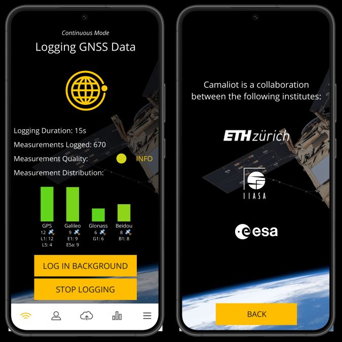
To scale up the data collection, we developed the CAMALIOT mobile app for Android phones, available from the Google Play Store. This is a lightweight application for recording raw GNSS data in the background (Figure 2). Users can see how many satellites are providing data from the different GNSS constellations such as GPS and Galileo during each data recording session. The coloured bars indicate the quality of the measurements; the more unobstructed the view, the higher the quality. Quality may also be affected by how good the mobile phone antenna is, which varies between mobile phone models. The app can run completely in the background and uses very little battery.
Once a session is complete, users can upload the data to the CAMALIOT server and contribute to the crowdsourced database. A new feature that automatically uploads the data at hourly intervals was implemented recently. The data collected by a particular user can also be downloaded by that user in RINEX format and used for their own purposes. Eventually, the database will become available through ESA’s GSSC portal, along with tools to process the raw GNSS data from mobile phones and other sources such as geodetic stations and drones. Note that the data will be completely anonymized and GDPR-compliant to ensure data privacy.
Billions of Measurements Collected with Crowdsourcing
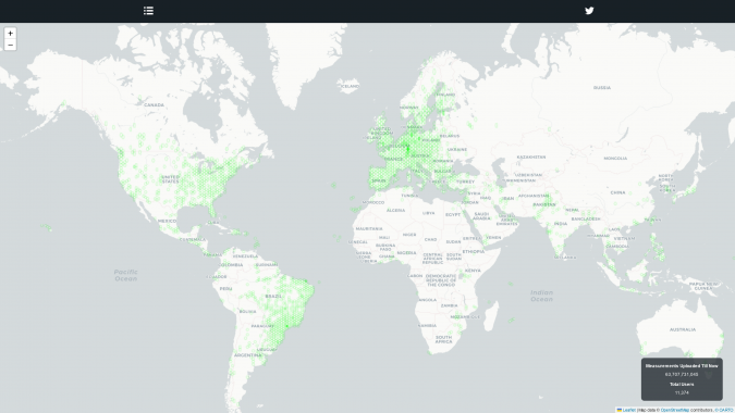
To initiate data collection through the CAMALIOT mobile app, a crowdsourcing campaign was launched on 17 March 2022 to encourage users around the world to download the app and contribute GNSS data. The details of the campaign can be found on the CAMALIOT website along with a video that explains the concept behind the data collection campaign. More than 11,000 participants have now contributed over 60 billion measurements distributed globally (Figure 3). The crowdsourced GNSS data will complement data from existing geodetic stations, expanding the network in places where stations are lacking and densifying it in places where stations exist. We hope to fill some of the gaps as the campaign continues.
To encourage participation, the app has a competitive element in which users have the opportunity to win prizes. These include a dual frequency Android mobile phone, Amazon vouchers and goodie bags containing CAMALIOT and other sponsored merchandise. Participants in the crowdsourcing campaign are entered into a draw to win these prizes, and the chance of winning is linked to the number of measurements uploaded during the campaign. This information is displayed on a leaderboard in the app. We want to show our appreciation to the participants and make the process fun, but also to raise awareness of the value of GNSS data.
We are also offering access to ESA’s GSSC Preview Programme on a first-come-first-served basis to the first 50 users that apply. This is another way for us to thank users for their contributions. The CAMALIOT website provides further details of how to apply for access.
Transforming Crowdsourced Data to Improve Weather Forecasting
Raw GNSS data from the crowdsourcing campaign is being used in combination with high-quality data from geodetic stations to explore two applications of weather forecasting, one related to the lower atmosphere (troposphere) and the other to space (ionosphere). By calculating the disturbances in the GNSS signal in the troposphere and the ionosphere, we can use machine learning to produce gridded products that can be used on an operational basis for forecasting.
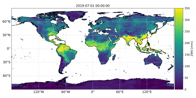
For the troposphere, time series of device-specific zenith wet delay (ZWD – Figure 4) are used in combination with meteorological inputs to spatially interpolate and forecast precipitable water vapour. Such measurements can then be assimilated into numerical weather prediction models with the goal to improve the nowcasting of precipitation at a local scale.
Concerning the ionosphere, GNSS measurements allow us to determine the total electron content, which we model on a grid with the help of machine learning. These models can be used to correct ionospheric disturbances that would degrade the positioning performance of single-frequency GNSS devices.
The crowdsourcing campaign runs until 31 July 2022, so there is still time to take part. Download the CAMALIOT mobile app from the Google Play Store today and contribute raw GNSS data from your phone. You can be part of an ongoing exercise that explores how raw GNSS data can be used for many different applications beyond navigation or you can use the data collected for your own investigations.