
Teledyne Optech and Teledyne CARIS have united to form Teledyne Geospatial in response to evolving marketplace needs. Under the Teledyne Imaging group, the harmony between the two business units is clear and the two teams were brought together to offer added value to customers through solutions across hardware, software and workflows.
Andy Hoggarth, Vice President, Sales and Marketing at Teledyne Geospatial, has been with Teledyne CARIS for almost 20 years. Beginning his geospatial career as a multibeam sonar processor using CARIS software at sea, he transitioned from working on the technical side of the business and is considered an expert in ocean mapping. Hoggarth’s role at the helm of sales and marketing is to understand trends and customer needs as they evolve and ensure that these are translated from idea to product. Teledyne CARIS has carved out a solid niche within the marine sector only to become broader via this new collaboration and, for Hoggarth, the synergies were clear: fusing the two companies reflects the natural evolution of the geospatial industry.
What opportunities does this new combined business provide for your customers?
“What’s new about this model is our ability to streamline and centralize our service provision, offering more to both new and existing customers across the spectrum of needs. Having a single contact point across all requirements means efficiency gains in terms of workflow, saving time and ensuring that our customers get what they need earlier.
“The needs of professionals are evolving to no longer focus solely on land or sea, and both geospatial and maritime enterprises are increasingly expected to offer a more comprehensive suite of services. Bringing Optech and CARIS together enables leveraging the world-leading expertise of both companies, ensuring that customers can take full advantage of their ability to provide targeted solutions for land, air and sea. We see new opportunities to connect existing hydrographic customers to the broader geospatial sector. We can offer solutions to a new spectrum of clients on the topographic mapping side through the latest geospatial workflow software, including tools like AI.”
Andy explains that he is most excited about the new possibilities that the merger provides for Teledyne customers to gain a competitive advantage in terms of what they can deliver. For example, processes will be further streamlined: customers can log their high-density, high-resolution Lidar data, store it in the CARIS cloud for immediate processing and analysis, and then move into downstream product creation workflow. This gives a clear operational advantage. This, in turn, enables customers to offer added value to their own clients in terms of the breadth of services they’re able to offer.
What does the merger mean for the CARIS and Optech teams?
“Joining forces means that the teams are gaining new skills across disciplines, and ensuring retention of the field-specific expertise they’re known for. The market is familiar with the strong customer service and support model, from engineering to sales, and nothing will change there. Teledyne’s arsenal includes hydrographers, physicists, surveyors and GIS professionals, as well as AI specialists, engineers and computer scientists. Going forward, the skills and expertise needed most in the field are at the intersection of traditional domain knowledge and the diverse aspects of computer science, as the market transitions to digital. I would suggest that there is an evolution underway in industry, and enterprises that can recruit highly skilled teams with expertise across the geospatial spectrum will be the ones to engage with. Our teams are industry professionals who understand both hardware and software and we see this as an opportunity to develop holistic solutions for hydrographic and topographic mapping.”
How does Teledyne Geospatial deliver a competitive advantage?
“Geospatial will have access to full range sonar, Lidar and software solutions so customers can get full value from their Teledyne investment with the most advanced sensors in both ocean and land environments. We are unique: while some providers have topographic sensors with integrated software, even bathymetric Lidar, our software workflow goes much further; others are not involved in the final delivery of data, whereas we have end-to-end capability. This is a huge advantage for our customers, who will be able to integrate workflows, create efficiencies and reduce silos. We will reduce the need for separate infrastructure for land and sea since we can support our customers on both. This is strategic for our customers at the business level, but also makes life easier in certain environments, for example in challenging and extreme settings such as the Arctic. This industry acumen means that Teledyne Geospatial is the ideal partner for a full range of projects.”
What have been some of the key challenges faced by the marine sector in the past year?
“No industry has survived the COVID-19 pandemic unscathed, including the marine sector. Operational challenges have been immense, with businesses forced to pivot their operations from the field or office-based work to dealing with the need to complete projects while necessarily working from home. Limitations like lower-power computers in home offices combined with the inability to travel to worksites to install and maintain hardware systems have only increased this complexity. Despite the roadblocks posed by COVID-19 restrictions, Teledyne has taken the opportunity to explore how to adjust operations and retain the highest level of service provision. A key priority has been to support our customers to transition their software to the cloud, enabling data processing and cartographic production. Digital and virtual interaction is a key part of our strategy, and we are now conducting much of our teaching and training virtually. On the upside, the pandemic has enabled us to reduce our carbon footprint from travel during this period, which also means less travel burden for our teams. As such, Teledyne is evolving with the industry and has managed to transition through the pandemic period into an even stronger position, having identified ways to make remote operations work successfully.”
An example of Teledyne’s recent innovation in terms of remote and autonomous operations involves hydrographic data scientists based in Canada, who would normally be on location in Brazil to perform a survey. Due to the COVID-19 pandemic, they worked remotely with colleagues in Brazil to operate survey equipment including AUVs through software workflows to command and control. As just one of many examples, Teledyne Geospatial will continue to apply this remote operations methodology where possible during the pandemic and its aftermath. In terms of the benefits for customers, some project costs are reduced and the reduced environmental burden is obvious, although companies may need to accelerate their investment in digital to make such remote operations successful.
Which technological developments should we be on the lookout for in the coming years?
“Adaptive capabilities, whereby enterprises can use the same systems for a multitude of purposes and adapt solutions to different survey tasks, will be imperative. With Teledyne Geospatial, customers will be able to use the same setup for ocean mapping and corridor mapping for powerlines, delivering a wider range of services. Lidar for both topographic and bathymetric purposes is a pertinent example of how one powerful tool can be applied across sectors. Going forward, UAVs and USVs will be critical, and our software can process the data from these drones, supporting automation.”
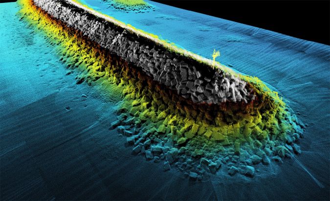
What has worked well in the past in shallow water has since demonstrated success in deeper water due to better capabilities, thanks to advances in Teledyne’s portfolio of solutions. For example, Teledyne recently began a partnership with the UK Hydrographic Office on The Nippon Foundation-GEBCO Seabed 2030 Project. This project aims to map the entirety of the world’s ocean floor by 2030, contributing to supporting maritime trade and protecting oceans, a critical weapon in the fight against climate change. Teledyne’s AI capability is used to process incoming multibeam bathymetry datasets more rapidly and accurately than previously possible, overcoming major bottlenecks created by the backlog of data. Enterprises should similarly consider next-generation tools and technologies, and AI will continue to gain momentum, for its capacity to enable accurate, fast data classification and data extraction.
What can we expect from Teledyne Geospatial in the years to come?
“At the heart of Teledyne Geospatial lies integrated solutions. The offering will include turnkey systems, Lidar, sonar, integrated workflows and a range of systems and solutions that support full, precise data collection. Geospatial will also work closely with Teledyne Marine, in particular concerning sonar systems, and both sonar and Lidar can be logged in CARIS’s recently launched Onboard360 acquisition software. With Onboard360, a near real-time and autonomous data acquisition and processing solution, it will become possible to create a common workflow using AI and cloud-native technology. For example, customers will be able to log data to the cloud with their hardware, streamlining their product timeline. A streamlined workflow for customers is a central, underpinning goal of Teledyne Geospatial.”
What new product developments can we expect to see in the coming months?
Andy regards software as a differentiator, enabling customers to get the most out of their hardware: “We will be releasing new software products in the coming months, which will allow users to get the most out of their sensors. An example of this is the recently launched CZMIL SuperNova, which combines Optech’s powerful bathymetric Lidar with CARIS’ comprehensive processing software.” Terratec AS, a leading Norwegian mapping company, has purchased and flown CZMIL SuperNova for airborne survey projects, collecting and processing marine coastal zone base maps and mapping Arctic lakes. Working with the CZMIL SuperNova sensor and AI techniques, they conducted automatic discrimination and noise classification, capitalizing on the system’s advanced capabilities and software workflow integration.
To get a first look at CZMIL SuperNova and to hear more about Teledyne’s other upcoming combined solutions, customers are invited to join the conversation under the new banner Teledyne Geospatial at its booths at key industry events in the coming months. Teledyne Geospatial will be Ocean Business in October and GEO Business in November, both in the UK. In the meantime, readers should reach out to Andy Hoggarth or Jennifer Parham for anything related to current or future Lidar, software and sonar needs.