3D Cadastre Modelling in Russia
Assessment of Added Value
Russia has the intention to develop and implement a 3D cadastre. A Russian-Dutch project on 3D cadastre modelling assessed the added value of a 3D cadastre. At present, the system of state cadastre and real estate registration in the Russian Federation is based on the 2D representation of objects including land parcels, buildings and structures. However, the current approach does not cover all situations of the real 3D world. Examples of such situations impeding cadastre and rights registration are: multilevel complexes, intersections of various objects in space, underground and elevated engineering networks, etc. The project included prototype development and a pilot.
The Russian-Dutch project entitled ‘3D Cadastre Modelling in Russia’ was implemented within the G2G Program of the Federal Service of State Registration, Cadastre and Cartography (Rosreestr) and Netherlands Kadaster from May 2010 to June 2012. The Ministry of Economic Development of the Russian Federation was a partner in the project. Project participants from Russia were Rosreestr, the Rosreestr Office in Nizhegorodskaya Oblast, Land Cadastral Chamber and the Federal Cadastral Centre ‘Zemlya’. The Dutch side was represented by Netherlands Kadaster, Delft University of Technology, Grontmij Nederland B.V. and Royal Haskoning B.V. Several use cases have been analysed.
Multilevel office building
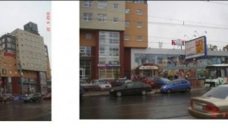
The first use case is the Teledom building (Figure 1). This is a multilevel office building with an underground car park and includes a large number of units with various types of registered rights. One part overhangs the road and another part is located above another building located on a neighbouring parcel. A 2D map of the land parcel would only represent the basement.
| Figure 1, Teledom building and its environment. |
The second case is an apartment complex with an underground car park (Figure 2). In this figure, Floor_01 has been dragged outside the building. Note the tooltip which contains the identifier of the object during move-over (apartment P7) and also note that the floor plan is dragged simultaneously with the 3D parcel (for reference purposes, but this layer can be switched off). This object is characterised by a large number of right holders who have registered various types of rights and restrictions, such as ownership, lease, etc.
The third case concerns a medium-pressure gas pipeline. It includes underground and elevated parts and is owned by Nizhegorodoblgaz (Figure 3).
The analysis of these use cases in terms of legal and organisational aspects showed that although currently the Russian registration and cadastre legislation does not contain references to 3D objects, nor does it present obstacles to the cadastral recording and registration of 3D parcels.
| Figure 2, Apartment complex with an underground car park. |
Information model
The developed conceptual 3D cadastre model is based on the ISO 19152 Land Administration Domain Model (LADM). The model was adapted to the Russian environment and oriented to five types of property objects: land parcels, buildings, premises, structures and unfinished construction projects. Coming from the 2D cadastre and registration system existing in Russia, the option of a legal 3D cadastre based on the representation of 3D objects as polyhedrons (volumes limited by flat faces) or as multi-polylines with diameters was selected as a working model. Curved surfaces are approximated by multiple flat faces. For technical implementation, a solution involving the existing 2D portal and linking it with a new 3D Viewer was selected. This solution is the easiest to implement and requires minimal changes, based on functionality supported by the existing 2D portal.
Prototype
For the development of the prototype and to test it on the cases, a package of data was
| Figure 3, The gas pipeline (the purple line) starts above ground near arrow and is partly below ground. |
acquired and processed according to requirements of the prototype, including:
- a topographic base map and a digital terrain model
- cadastral data including boundaries and characteristics of cadastral blocks and land parcels
- information on state registration of land parcels, buildings, premises and structures
- technical documentation including technical passports with floor plans, etc.
In order to optimise the 3D cadastre prototype using floor plans and additional information, 3D models of buildings were developed reflecting volume characteristics of premises with the concurrent representation of respective right holders in conventional colours (Figure 4).
Interface
The prototype works with Internet Explorer and Firefox in combination with a plug-in (BS Contact) for the visualisation of and interaction with the 3D objects. The interface consists of three main components including (Figures 2 and 4):
- the 3D Viewer itself, allowing various options for the visualisation of an object and its parts, including rotation, zooming, switching certain features on/off, and some special functions (e.g. ‘identify’ and ‘move floors’) for viewing more details
- the ‘Select’ window allowing various options for the selection and visualisation of 3D parcels within a 3D object pursuant to given criteria
- the ‘Selection Results’ window allowing information about selected objects to be viewed.
The prototype supports selection based on multiple attributes (owner name, ID of cadastral object, address, etc.). There is the option to show privacy data or not (depending on user's right of access), to show / hide layers such as the 2D cadastral map, topographic map, or areal/space image, and to show / hide elements in the 3D model itself: floor plans, walls or any elements that are not selected by the user at that time. A link to a photograph or web page can be included for each 3D object.
| Figure 4, The Teledom building with the various 3D units as prepared in Google Sketchup. |
Pilot and evaluation
The purpose of the pilot was to evaluate implemented prototype functionality, determine directions for future developments, and evaluate the feasibility of using 3D cadastre data both for better registration and cadastral recording and for expanding e-services to various groups of users.
The expert evaluation of testing results was made on the basis of a questionnaire. Results from the pilot and the questionnaire show positive attitudes to the possible introduction of a 3D cadastre in the Russian Federation. The suggestions made by the participants, which included having better contact with users/clients, indicate the high level of interest and expectations. The users/clients need to be informed in a timely manner, and if necessary offered training, in order to be able to handle expected changes and, to obtain real benefits, the needs and views of potential users need to be taken into consideration.
Next steps
Using the results of the project and the prototype testing, recommendations were drafted on legal, organisational and technical aspects in order to establish favourable conditions in Russia for the introduction and maintenance of a 3D cadastre in an operational, real-world situation.
It should be noted that, with such conditions in place and supported by a production system, any appreciable additional costs of registering and recording 3D objects are not expected. Meanwhile, in terms of benefits, the gains are huge: a better description of objects and ownership rights, restrictions or responsibilities in the complex situation where society is becoming very concerned about high real-estate values in dense urban areas. Also, using 3D cadastre is in line with the up-to-date and innovative image of Rosreestr in the sphere of information technology. Hence, after initial system development (extension), there are practically no extra costs, and its introduction will not affect registration and cadastre workflows within Rosreestr. It should also be taken into consideration that new cadastral objects (new buildings or facilities) are often architecturally designed (with CAD) directly in 3D. Thus, with a minimum of additional effort, it is possible to use 3D objects for registration and cadastre.
More tests in an operational, real-world situation are needed to establish the optimal system architecture and to compare alternative software solutions, such as for the visualisation component. A production environment with more functionality should be developed, including: a validator, DBMS data storage, on-the fly creation of the 3D web visualisation from a data stream obtained from the database, and an extension of the 3D viewer to also show neighbouring units in 3D.
Further activities on the introduction of 3D cadastre and interaction with potential users both in Rosreestr and among a wider circle of users will enable identification of the most effective ways of implementation and specification of the list of information products to be generated using 3D cadastre data about complex and real property objects.
Acknowledgements
The authors of this paper would like to express their gratitude to the partners and colleagues within the project: Galina Elizarova, Sergey Sapelnikov, Sergey Pakhomov, Russian Federation, Marian de Vries, Jantien Stoter, Hendrik Ploeger, Boudewijn Spiering, Andreas Hoogeveen, The Netherlands and Veliko Penkov, Bulgaria. This research is supported in part by the Dutch Technology Foundation STW.

Value staying current with geomatics?
Stay on the map with our expertly curated newsletters.
We provide educational insights, industry updates, and inspiring stories to help you learn, grow, and reach your full potential in your field. Don't miss out - subscribe today and ensure you're always informed, educated, and inspired.
Choose your newsletter(s)


