3D modelling of buildings using TLS technology
Modelling for reconstruction needs and BIM development
Terrestrial laser scanning is becoming increasingly important as the software and technology-related developments in many spheres of society mean that ever-higher standards are being set in terms of quality and time.
The developments taking place in software and technology in many spheres of everyday life and business mean that higher and higher standards are being set in terms of quality and time. In the field of the 3D modelling of buildings too, there is an increasing emphasis on obtaining a highly detailed, high-quality 3D model in near real time. As a result, the terrestrial laser scanning (TLS) method is becoming increasingly important.
TLS technology involves the use of a laser scanner mounted on a static tripod. A beam is emitted from the laser sensor and the time taken and therefore distance travelled is measured for the beam to travel to the object and back. By combining this distance with the known position of the laser scanner, a large number of points can be obtained, leading to a point cloud that represents the surrounding space in three dimensions. When surveying buildings and similar spatial entities, a laser scanner can be placed at multiple stations to cover the entire object. It is important to ensure an appropriate overlap between the scans obtained at successive stations, based on which individual scans are imported and processed into a complete 3D representation of the building.
Advantages of terrestrial laser scanning
TLS has many advantages over traditional surveying methods. For example, it increases productivity, as a large amount of high-density data can be collected in less time and with fewer resources. Much more information is also obtained: apart from 3D positional information, the obtained data includes reflected intensity values and colours if the TLS has an integrated RGB camera. This makes it easy to create an accurate geometric model and to extract the required data such as dimensions, spatial positioning and structural characterization.
TLS is also an easy-to-use technology: it is a fairly automated surveying procedure and learning how to use the instrument does not take much time. Furthermore, it is a non-contact technology, enabling surveying in hard-to-reach areas and improving safety in hazardous environments. Finally, it has a relatively high accuracy. Although the single point accuracy of TLS is usually lower than traditional techniques, it can be improved through adjustment techniques and the accuracy achieved using this method is satisfactory for most applications.

TLS surveying and creation of 3D model
The process of TLS surveying and the creation of a 3D model of a building as implemented in this article is shown in Figure 1.
Survey planning includes defining the area to be surveyed; defining the expected resolution and accuracy of the point cloud; selecting the scanner to be used; choosing optimal locations for the scanning stations; and choosing types of targets for registration and georeferencing, places for their location and their geometric configuration.
In the field, the operator must first set up the instrument at the defined location, define the 3D section of the scene to be captured and select the necessary options in the software (e.g. sampling resolution, accuracy mode, number of scans, first or last pulse measurements). Once scanning has started, the operator can follow the process on the screen of the TLS or remotely on a laptop, mobile phone or tablet. When the scanning is complete, the data is saved in a specified project file. As mentioned earlier, large objects need to be surveyed from several locations. The scans obtained at each station are referenced to the instrument-fixed, in other words internal coordinate system of the scanner. Hence, scans should first be transformed to a common coordinate system. This procedure is called registration, following which the registered scans are combined into a single dataset. After this, the point cloud can be georeferenced and further 3D models and views can be created.
Surveyed building
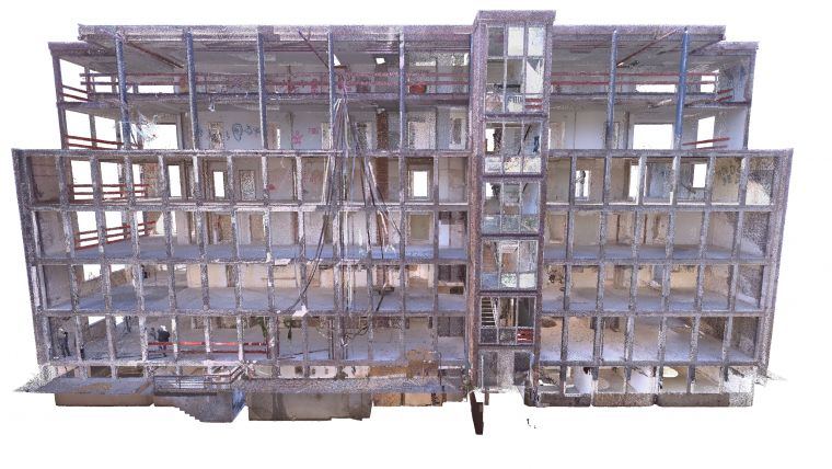
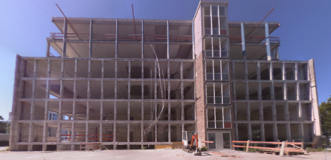
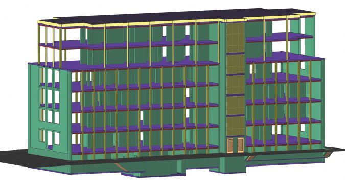
The surveyed building presented in the article is located near Frankfurt, Germany. The building consists of a basement, ground floor and five floors (Figure 2).
Scanning using TLS was performed to obtain a 3D model of the building for the needs of reconstruction (to design a new interior and exterior) and as a basis for the development of a BIM (Building Information Model). The laser scanner used for surveying was the Trimble X7.
Data processing
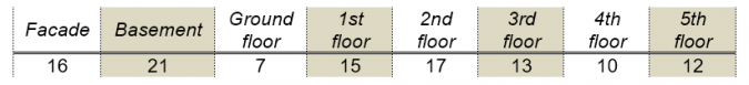
A total of 111 scans were performed, with the number of scans per floor given in Table 1. After collecting data in the field, the scans were imported into the Trimble Business Center software and registered (Figure 3).
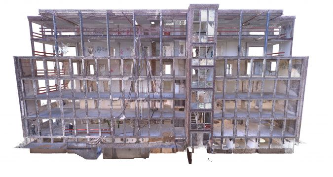
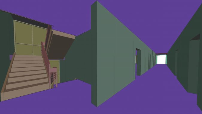
Based on the obtained point cloud, the 3D modelling of the facade and all the surveyed floors of the building was performed using Revit software. The result of 3D building modelling is a .ifc (industry foundation classes) file. Figure 4 shows the whole 3D model of the building, while Figure 5 shows the part of the 3D model that represents the interior of the building.
Conclusion
The impact of the development of technology and software in recent decades is evident and has consequences for geodetic engineering and the 3D modelling of buildings. TLS is a modern method that is increasingly being used to create 3D building models. This technology enables the collection of large amounts of high-density and detailed data in a much shorter time and with fewer resources. The data collection and processing are largely automated and allow for additional analyses, updates and changes to spatial data. Finally, artificial intelligence and virtual reality are also increasing in importance in many areas of life and work, and it is only a matter of time before we see the further expansion and development of geodetic methods that incorporate these modern concepts.
Further reading
- Rashidi, M. Mohammadi, S.S. Kivi, M.M. Abdolvand, L. Truong-Hong and B. Samali, A decade of modern bridge monitoring using terrestrial laser scanning: Review and future directions, Remote Sens., vol. 12, no. 22, pp. 1–34, 2020.
- Wu, Y. Yuan, Y. Tang and B. Tian, Application of Terrestrial Laser Scanning (TLS) in the Architecture, Engineering and Construction (AEC) Industry, Sensors, vol. 22, no. 265, 2022.
- Kuzmić, M. Marković, M. Batilović and V. Bulatović, Application of Terrestrial Laser Scanning Technology for the Purpose of Creating 3D Models of Objects, FIG e-Working Week 2021 – Smart Surveyors for Land and Water Management – Challenges in a New Reality, 21–25 June 2021.

Value staying current with geomatics?
Stay on the map with our expertly curated newsletters.
We provide educational insights, industry updates, and inspiring stories to help you learn, grow, and reach your full potential in your field. Don't miss out - subscribe today and ensure you're always informed, educated, and inspired.
Choose your newsletter(s)


