AI-powered Object Detection as a Mapping-business Accelerator
Geospatial Imagery Analytics Market Expected to Reach US$8 Billion by 2025
UAV, aerial and satellite mapping service providers are competing for the global market – with a rising hunger – for geospatial insights. Automating the feature extraction process is key to accelerating, scaling up and diversifying a location intelligence service portfolio. Cloud-based platforms coupling cutting-edge machine learning research with a user-friendly implementation offer a powerful turnkey and cost-effective solution to those looking to gain competitivity by incorporating artificial intelligence (AI) automation into their workflows.
With more and more business relying on location data to optimize their planning and day-to-day work or to gain first-hand market insights, the geospatial imagery analytics market is poised to rise from around US$2 billion in 2018 to over US$8 billion by 2025, according to a 2019 Global Market Insights, Inc. report. This is a huge opportunity for unmanned aerial vehicle (UAV or ‘drone’), aerial and satellite mapping service providers. The key to capturing a share of this growing market is to offer business solutions focused on specialized geospatial analytics.

Business and industries in need of geospatial analytics are increasingly diverse. For example:
- Farmers need to know how many of their plants are underproductive
- Ranchers need to know how many heads of cattle survived after a flood
- Insurance companies need to know how many roofs were damaged during a storm
- Electricity companies need to know how many solar panels are there in a city
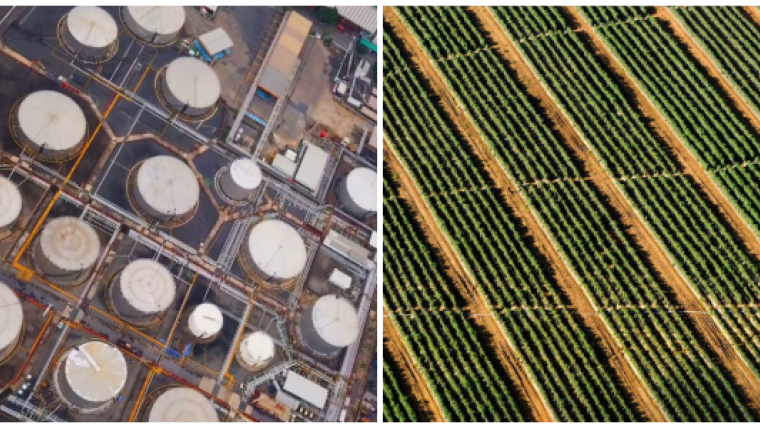
- Oil companies need to detect oil spills
- Water companies need to know how many manhole covers are damaged or stolen
The applications and use cases are potentially endless. All of these businesses need the number and the location of each of the objects they are tracking.
The challenges of scaling up
Most of the UAV, aerial and satellite mapping service providers we speak with daily excel at producing digital mapping and surveying products. However, delivering geospatial insights derived from these products can be challenging and quickly become a bottleneck when scaling up the production pipeline. No one questions the potential value that these insight-rich geospatial products can add to their service portfolio, but so far they have proven hard to scale.
Manually extracting the features the clients are interested in is time-consuming and costly to scale up by engaging additional manpower. Automating this process by developing an in-house AI programme implies a huge investment. Hiring highly specialized professionals – machine learning experts, computer vision specialists and data scientists – and investing in infrastructure is not an option for small and medium-size drone service businesses. One cost-effective solution to automate the feature extraction process and increase the geospatial analysis production capacity is to use Picterra, a cloud-based AI object detection platform.
Incorporating Picterra into the production pipeline of a UAV, aerial or satellite mapping business has multiple benefits. This list presents the top seven reasons:
1) 100x faster – Reduce turnaround time and increase turnover
Firstly, not only can AI improve the accuracy of the project, but it can also reduce the time to delivery. The entire workload of mapping, detecting and extracting data can take days if being done manually. Instead, AI-powered automated detection can shorten the delivery time from days to minutes. Furthermore, by being freed from the repetitive manual process, you can use that amount of time to work on a new project or acquire new clients.
2) 90% cheaper than developing an in-house AI programme – Avoid unnecessary investment
You don’t need to invest in infrastructure or R&D. GPUs and highly specialized expertise are expensive. For instance, several thousands of dollars are needed to use a high-end GPU virtual machine on cloud services, on top of which the expertise required in-house can quickly bring the expenses to tens of thousands of dollars per month. With an online platform, these are built-in components you can directly leverage on. With Picterra, you get state-of-the-art machine learning algorithms and infrastructure without the need for extra expertise.
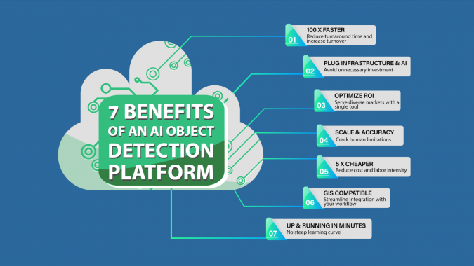
3) One tool for all – Serve diverse markets with a single tool
Maximize your ROI by using a single tool for all of your feature extraction projects. Thanks to the versatility and flexibility of the object detection algorithms Picterra deploys, you can customize them and count objects such as trees, sheep, solar panels, shipping containers or buildings today. At the same time, you will be able to craft a detector for any other type of object.
4) 95% accuracy – Crack human limitations
The AI-powered platform can detect objects faster and more efficiently than a human being. It is able to cover large areas and spot tens, hundreds or thousands of objects in the blink of an eye. In addition to the scale at which it can operate, AI can also improve the accuracy of the detections. Even the most meticulous person is bound to make mistakes while carrying out monotonous manual detection over a large scale. This is where automation helps by learning features, performing the same steps accurately every time they are executed and focusing the human expertise on challenging and rare features.
5) 5x cheaper than manual detection – Reduce cost and labour intensity
The same heavy workload being repeated with every project requires more cost and labour intensity to deliver the results in time. In contrast, once created , automated detection can be executed again and again, without additional cost at a much faster pace. By integrating AI in the process, the overall timespan can be reduced which translates directly into cost savings.
6) Streamline integration with your workflow
You can run AI object detection on satellite images or orthophotos produced with any photogrammetry software in the market, such as Reality Capture, DroneDeploy, Agisoft Metashape, SimActive Correlator3D or Pix4Dmapper. Picterra allows you to analyse the detections, derive statistics and generate customized reports you can deliver to your clients. You can also export the detections as georeferenced layers in various formats that are optimized to match your workflow on ArcGIS and other GIS software.
7) Build and run a detector in 10 minutes – No steep learning curve
Last but not least, the Picterra platform offers you an intuitive user interface that allows you to build and run your own detectors in just a few clicks.
AI object detection in action
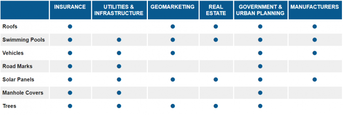
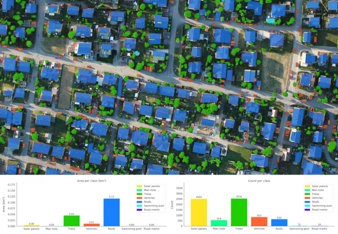
Picterra was used to perform automated analysis of the content of an orthomosaic of a neighbourhood of the German town of Walddorf. Seven object categories were mapped and localized over the urban scene, generating GIS layers and a report as outputs.
- Roofs: up-to-date detections give local governments and insurance companies insights on discrepancies on declared values and a correct parametrization of the prime.
- Swimming pools: local governments can localize swimming pools and compare this information with building permit registers. Moreover, tax declaration discrepancies can be spotted.
- Vehicles: car dealers can use this information to target marketing campaigns, local governments to plan parking infrastructure and road network adaptations, and real estate agencies to spot and assess the most frequently visited areas and shop windows.
- Road markings: up-to-date detections provide key insights to local infrastructure and traffic agencies or insurance companies when analyzing the geographic prevalence and distribution of traffic accidents. Moreover, this supports an efficient maintenance planning of road markings.
- Solar panels: determining their prevalence and geolocation unlocks key market insights for energy companies and solar panel manufacturers. An optimized management of the supply and demand of renewable energy also requires up-to-date information on the solar panel locations.
- Manhole covers: water and utility companies need this information in order to plan maintenance and network expansion.
- Trees: detecting trees in proximity to key assets provides insurance companies with valuable risk assessment information. Detecting trees encroaching on buffer zones is also key to infrastructure planning such as gas pipelines or overhead power lines.
Picterra offers a powerful, cost-effective, cloud-based object detection solution that can be incorporated in UAV, aerial and satellite mapping pipelines to scale up and diversify location intelligence products and services.
More information

Value staying current with geomatics?
Stay on the map with our expertly curated newsletters.
We provide educational insights, industry updates, and inspiring stories to help you learn, grow, and reach your full potential in your field. Don't miss out - subscribe today and ensure you're always informed, educated, and inspired.
Choose your newsletter(s)


