Augmented Reality Mode Helps People to See beyond the Map
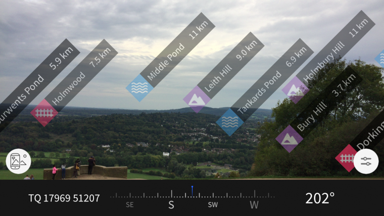
Have you ever wondered what the name of that hill is in the distance? Or how far away a town is from the spot you are standing in? With the new augmented reality (AR) feature of Britain’s mapping agency Ordnance Survey (OS), all you need is a smartphone or tablet. The OS Maps application, GetOutside, now includes an AR feature which can call on over 200,000 locations throughout the UK.
Using the phone or tablet’s camera view; hills, mountains, coastal features, lakes, settlements, transport hubs and woodland in the vicinity are identified and labelled. If a label is pressed and there is a data connection, a page of useful information about that location is displayed, including nearby walks, photos and places to stay.
Environmental context
The aim is to improve people’s knowledge of their location by helping them see beyond the edge of the map, explained Tim Newman, digital product manager at Ordnance Survey. Newman stated that OS helps people to GetOutside more often through their passion to make outdoor activity more enjoyable, accessible and safe. This fantastic new feature really gives you a clear and accurate context of your environment. While it is always recommended to carry a paper map when outside (they never run out of batteries!) OS recognise that people are increasingly enjoying the benefits of using mobile phones for navigation. Mobiles can provide you with excellent knowledge of your immediate surroundings but you can lose the wider perspective on a small screen.
The new augmented reality view helps address this by showing what is on the horizon. Newman hopes people will find this fun and informative, as well as being a useful tool to help improve basic navigation skills.
The new AR feature which is free to subscribers of OS Maps follows hot on the heels of the award-winning 3D map and route planning features launched earlier this year. The team are constantly improving OS Maps and more new features are planned in the coming months. As of October 2017, there are more than 1.2 million routes in the app, and full country coverage of both Landranger and Explorer mapping.
Visit www.os.uk/getoutside/AR to find out more.

Value staying current with geomatics?
Stay on the map with our expertly curated newsletters.
We provide educational insights, industry updates, and inspiring stories to help you learn, grow, and reach your full potential in your field. Don't miss out - subscribe today and ensure you're always informed, educated, and inspired.
Choose your newsletter(s)


