
AXIS GeoAviation Acquires Additional Aircraft and Sensors
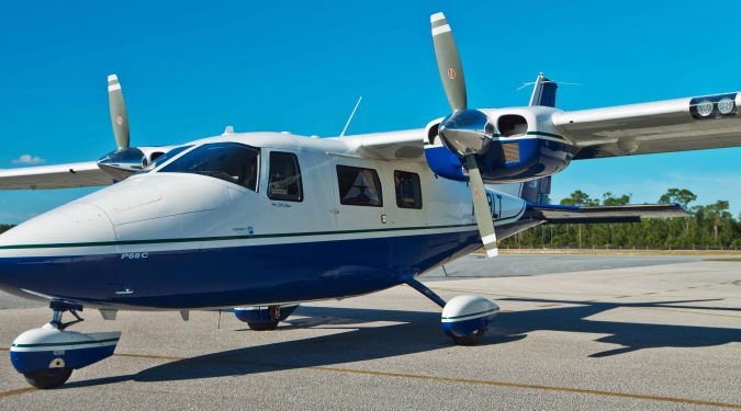
AXIS GeoAviation (AGA) has announced the newest addition to its fleet: a Vulcan Air P68C twin-engine aircraft. The additional plane allows AGA to support future aerial surveying and mapping projects in the southeast USA, Caribbean and nationwide. AGA’s sister company, AXIS GeoSpatial (AGS), recently acquired Mapping Resource Group of Florida with a significant customer base in the southeast and the mid-Atlantic regions of the US and the Caribbean. The Vulcan P68C provides the additional capacity to serve AXIS’ clients, as well as versatility in that it is fast enough for aerial imagery collection yet can be flown slower and at lower altitudes to capture higher-density Lidar data. Additional aircraft in AGA’s fleet include a Cessna 206H and a Piper Navajo.
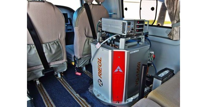
In addition to its growing fleet, AGA has expanded its capability to collect Lidar data through the purchase of two RIEGL VQ-1560i dual-channel airborne mapping sensors. AGA invested in the additional Lidar sensors to meet the increasing client demand for higher-density datasets. As experts in high-definition Lidar acquisition, AGA offers survey data collection, processing and classification for design-scale mapping of airports, college campuses, environmental remediation, highways, railroads, pipelines, corridors and other design and maintenance projects. Currently, AXIS GeoAviation is the only company on the east coast of the United States to own two RIEGL VQ-1560i sensors.
Evolving geospatial technology trends
Justin Lahman, CEO of AXIS GeoAviation stated AXIS sees rapidly evolving technology trends that will transform the way in which civil engineers, architects, infrastructure managers, and GIS professionals plan and design solutions for tomorrow’s geospatial needs. The latest expansion and investments are based on AXIS’ predictions of the innovations that will redefine the scope of work in tomorrow’s surveying, engineering and geospatial markets. The company’s positioning is founded on intelligent preparation for the future; using the past only to make smarter predictions, Lahman added.
The new acquisitions bring the total assets owned by AGA to three fixed-wing manned aircraft, two Unmanned Aircraft Systems (UAS), one Vexcel UltraCam Eagle system, one RIEGL LMS-Q1560 Lidar sensor, and two RIEGL VQ 1560i Lidar sensors. AGA currently employs four pilots and eight crew members operating out of its Easton, Maryland and Ormond Beach, Florida hangars.

Value staying current with geomatics?
Stay on the map with our expertly curated newsletters.
We provide educational insights, industry updates, and inspiring stories to help you learn, grow, and reach your full potential in your field. Don't miss out - subscribe today and ensure you're always informed, educated, and inspired.
Choose your newsletter(s)


