Building a digital twin for Germany
Using large-scale, high-resolution Lidar to support policymakers
The German Federal Agency for Cartography and Geodesy (BKG) is creating a digital twin of the whole of Germany that can be used to simulate various future scenarios in order to adequately address societal challenges, such as the increasing use of land, rising energy demands and extreme weather. This digital replica of Germany will be built as an intelligent 3D world containing all the essential geospatial objects, enabling the relevant processes to be mapped holistically and in relation to each other based on a common data foundation. This is intended to support faster, more informed and more reliable decision-making.
Digital twins have long been a reliable tool in industrial production to mirror processes in their entirety. All relevant aspects, functions and properties of an object or manufacturing process are considered in the modelling to allow for the simulation or monitoring of alternatives as the basis for faster, more informed and more reliable decision-making. Transferring this concept to a wider geographical scope, such as an entire country, poses challenges ranging from technological scaling and modelling to information management and data integration. However, recent advancements in information technology – such as increased processing capabilities through cloud computing and artificial intelligence, as well as improved surveying techniques and methodologies that allow accurate, large-scale Lidar capture – now put the prospect of a nationwide digital twin within reach and offer tremendous untapped potential.
Information, insights, impact
Increased land consumption, the growing demand for energy, limited natural resources, sociodemographic changes and extreme weather events are just some of the challenges that current and future governments face. The causes and effects of these issues often are interwoven. Data-driven methods are needed to address them effectively. A holistic, cross-domain approach offers a chance to account for the correlations between them and to provide additional insight. As such, a spatially explicit and comprehensive common foundation of data is integral to an increasing number of decisions within government administrations. Often, the solutions to these problems are not binary but rather contain a spectrum of alternatives and mitigation measures. To compare the impact of different policy decisions, a common data basis and framework are paramount – and that is precisely what the Digital Twin Germany platform is intended to provide.
Why Lidar matters
What potential does this data hold? Accurate topographic information is already being used for countless scientific projects, feasibility studies, planning assessments and more. When it comes to geodata, the sky is the limit. Current projects range from hydrologically sound models to simulate flash flooding due to heavy rainfall, to urban climate analysis which requires information about the height of buildings in order to model air flows. Large-scale Lidar, like single photon or Geiger-mode Lidar, is an accurate data collection method for the canopy height and density of trees in a forest. The data can then be used in biogeochemical models to estimate carbon capture. Lidar data can also elevate existing applications such as remote sensing data.
The Digital Twin Germany platform entails the collection of data for the entire country/federal territory consistently and in unprecedented detail, so that interconnected problems become more visible and easier to target for stakeholders within governments and other interest groups. Improved data resolution and height accuracy will also further enhance existing solutions and open up new possibilities.
Making sense of 3D data
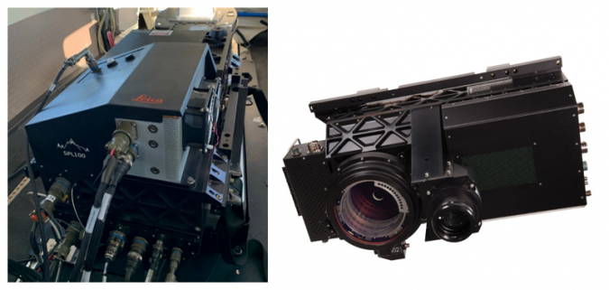
A high-precision 3D model captured using modern, airborne laser scanning technology forms the foundation of Digital Twin Germany. To capture an area as large as Germany in a timely manner, conventional Lidar methods are not sufficient. Instead, state-of-the-art capturing techniques are required such as Geiger-mode Lidar (GmL) or single photon Lidar (SPL). These systems offer a balance of large-scale area coverage while maintaining the high resolution necessary for quick and efficient surveying of topology features across the entire country. Like conventional or linear Lidar, both these methods rely on the time-of-flight measurement method: the travel time difference between the emitted laser impulse and the detection impact of the reflected echo.
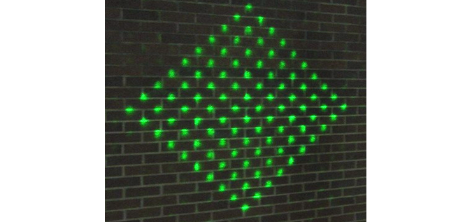
Both techniques enable the capturing of objects in their entirety and with a high point density. However, the two methods differ in wavelengths used; SPL uses wavelengths on the green spectrum. This laser is split into a 10x10 array of beamlets using a diffractive optical element (see Figure 2).
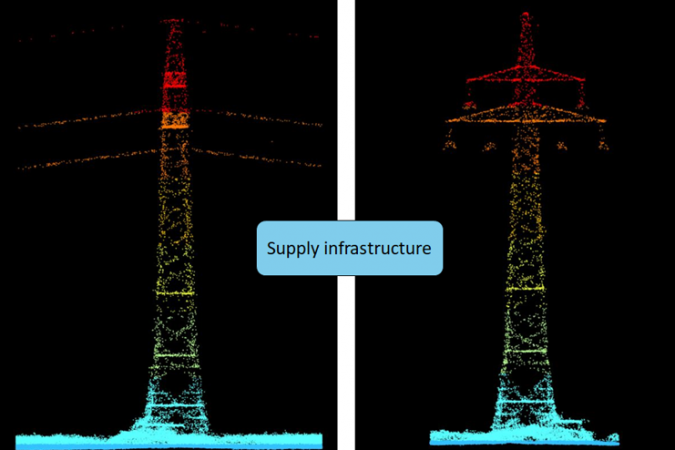
To achieve a height accuracy of better than 10cm, the point density for Digital Twin Germany is proposed at 40ppm² (see Figure 3). This resolution enables objects to be detected reliably and the creation of a realistic mirror image that can even include bushes beneath tree crowns. The entire area is going to be recaptured every three years. This supports not only accurate and consistent measurement and simulation, but also change analysis.
The accuracy and scale of the digital twin are currently unmatched in Germany. The quality of the data is being further enhanced by adding satellite and real-time data, facilitated by artificial intelligence (AI). The use of AI enables objects to be detected and classified automatically from the raw data and subsequently made available for analysis.
Expert data makes the difference
The second step is to enrich the basic dataset with a wide variety of expert information layers, including information on climate, infrastructure, agriculture, traffic and satellite images, for example. This additional information is superimposed on the virtual 3D world. Together with other cutting-edge digital technologies and methods, such as the Internet of Things (IoT), AI, cloud computing, big data analytics and modern visualization techniques, more and more opportunities are opening up in the geoinformation sector. The result will be a highly complex, consistent and dynamic model of Germany comprising as much data as possible from the federal administration. Since BKG is the key geodata provider for the federal government’s spatial data infrastructure, it has a large amount of national geodata at its disposal. All this data will be the starting point for building Germany’s digital twin. To ensure that all users are provided with comparable and interoperable data, data will be collected consistently across the entire federal territory and will be updated regularly.
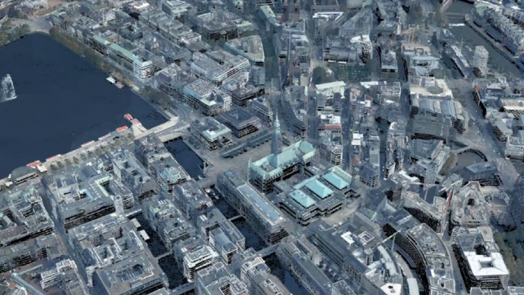
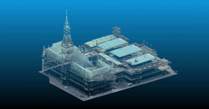
Surveying the city of Hamburg
A pilot project is currently underway at BKG to test the feasibility of this vision. In a joint project with the State Office for Geoinformation and Surveying of the Free and Hanseatic City of Hamburg and the Hamburg Metropolitan area, implementations are being tested, data validated and technologies and methods explored. For this, an extensive area of the Hamburg metropolitan region has been surveyed by Hexagon using a Leica SPL100. The aim is to gain experience in the handling of the data and learn about all aspects of the digital twin process, from data capturing to data management and analysis. The pilot project is scheduled to end in spring 2022. The lessons learned are to be adapted for the main project itself, which aims to capture federal Germany in its entirety and is due to start in 2023.

Not just a technical solution
As mentioned above, Digital Twin Germany goes far beyond the structure of a 3D model. In addition, the aim is to develop and establish communication channels and networks of stakeholders at federal and state level. In general, it should enable policymakers and decision-makers to monitor specific conditions and test scenarios. Predictions can be made about how a system will react to changes and modifications. This creates new decision-making tools with which public-sector employees can optimally manage their tasks. For example, one interesting application in the federal administration is a nationwide environmental monitoring system. Details about precision agriculture, water management, air pollution and climate change are of particular interest. There is also potential in relation to smart cities, since digital twins help city administrations to fulfil their tasks in a more environmentally, economically and socially compatible way. They can be used to visualize future plans and test solutions to the complex problems cities face. Other applications include spatial planning that takes climate change into account, monitoring and modelling of ecosystems, simulation of sea level rise in the North and Baltic Seas, forest condition monitoring, and traditional application areas of change analysis.
Interoperability: interfaces to other digital twins
Digital Twin Germany is an essential component in Germany’s journey to become a smart country. The European Commission (EC) has realized the potential of digital twins and plans to create a digital replica of Earth within the next decade. The ‘Destination Earth’ initiative builds on the EC’s Green Deal and Digital Transformation programmes. On a more local level, several digital twin initiatives for cities and municipalities are also underway. BKG aims to position its endeavour in the gap between international and local initiatives. As such, interoperability of services and data and the sharing of knowledge, data and tools are considered crucial steps in realizing the full potential of not just one, but all of these projects.
Conclusion
At the forefront of applying the newest Lidar advances, BKG is playing a crucial role in supporting Germany on its path to become a smart country aimed at making better decisions faster.
Acknowledgements
BKG would like to thank Hexagon for the data acquisition in the pilot project as well as for providing photographs and figures for this publication.

Value staying current with geomatics?
Stay on the map with our expertly curated newsletters.
We provide educational insights, industry updates, and inspiring stories to help you learn, grow, and reach your full potential in your field. Don't miss out - subscribe today and ensure you're always informed, educated, and inspired.
Choose your newsletter(s)


