Cadastral System in Malaysia
RTK ion Updating Coordinate System
A virtual reference station (VRS) was introduced in Malaysia employing real-time kinematic (RTK) equipment. The project for updating the coordinate system, designated Coordinated Cadastral Infrastructure (CCI), requires that all reference points in Malaysia be surveyed to update the coordinate data and demonstrate specified accuracy.
Malaysia's real-time kinematic (GPS) network (MyRTKnet) is a VRS differential system covering the entire area of Malaysia. The system includes 27 GPS reference stations (Trimble 5700) and central processing software (Trimble).
The differential data is broadcast via the internet; users can download it by communicating with the service centre using either Global System for Mobile communications (GSM) or General Packet Radio Service (GPRS). Users can also download raw GPS station data from the data service centre. This system is used in surveying and many other fields.
The VRS project began at the end of 2006 and was completed in May 2007; individual services are listed in Table 1.
CCI Project
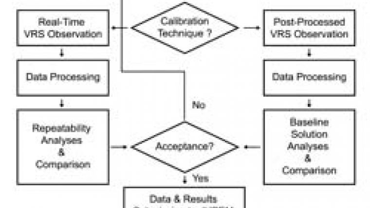
The basic project for updating the coordinate system after the introduction of VRS throughout the country was dubbed CCI. All equipment must be calibrated before being used in the project. The calibrated equipment can be tested using either the GPS digital elevation models (DEMs) calculated by Jabatan Ukur dan Pemetaan Malaysia (Department of Survey and Mapping, Malaysia, JUPEM) or primary GPS network stations within MyRTKnet coverage. Access to this information is by connecting any mobile receiver to a data mobile phone and data collector (as recommended by the GPS manufacturer; a cut-off angle of fifteen degrees [15°] should be applied.) Real-time data surveyed by VRS should be compared to the results of post-processed raw data from the virtual Rinex centre. The accuracy must satisfy JUPEM standards (horizontal <2cm, vertical <6cm).
Receiver Tests
JUPEM selected the E650 global navigation satellite system (GNSS) receiver designed by UniStrong on tender. More than a hundred receivers were employed in the CCI project, each tested on high-grade reference points and meeting the prevailing strict standards. Tests proceeded according to certain parameters (see Figure 2). Each reference point was surveyed twice, ten epochs or sets of data being recorded (see Table 2). The two sets of survey data should be comparable within certain limits (see Table 3). The unit will pass the real-time test only if differences of <2cm (horizontal) and <6cm (vertical) are detected.
Raw data should be sampled twice, for 5 minutes, in order to determine the post-processing result. Survey results are compared in the same manner as above. Finally, the average of the real-time results is compared with average post-processing results (Table 4). The coordinate difference must lie within the above limits. The final coordinates are the average of the two results.
Test Pass Rate
In order to ensure fast and accurate completion of the CCI project every GPS receiver was submitted to the tests described. The test pass rate on all receivers was 99%. All the equipment can be quickly and accurately connected to VRS using GPRS provided by Maxis Communication Berhad, a mobile-communications service provider in Malaysia.
Acknowledgements
Thanks are due to Malasia Koperasi Jurukur Tanah Berlesen Berhad (KOJUTA), association of surveyors in Malaysia, Soeb Bin Nordin, assistant director of survey, JUPEM Geodesy Section, and to Munsan Woon, managing director, Pristine Dragon Sdn Bhd.
Table 1: Services provided by MyRTKnet
| Services
| Details/description
| Accuracy
|
| Network-based RTK
| GPS network consisting of multiple reference stations, estimating the error model of GPS for a region and providing RTK correction data to end users
| ±2-3cm (up to 30km outside network)
|
| Single-based RTK
| RTK correction data from a single reference station in the network
| ±2-3cm (30km radius)
|
| Network-based DGPS
| As for network-based RTK, except that differential data is provided to end users
| ±20-50cm (up to 150km outside network)
|
| Virtual Rinex
| Generates virtual Rinex data from the GPS network
| -
|
| Reference station Rinex
| Provides Rinex data for a reference station in the GPS network
| -
|
Table 2: Survey Reference Points
|
| Latitude (N)
| Longitude (E)
| Ellipsoidal height (m)
| |||||||
| Epoch
| °
| '
| "
| RMS (m)
| °
| '
| "
| RMS (m)
| Observed
| RMS (m)
|
| 1
| 2
| 52
| 7.59522
| -0.0108
| 101
| 52
| 12.42953
| 0.0061
| 37.662
| 0.0532
|
| 2
| 2
| 52
| 7.59525
| -0.0100
| 101
| 52
| 12.42953
| 0.0061
| 37.677
| 0.0688
|
| 3
| 2
| 52
| 7.59562
| 0.0011
| 101
| 52
| 12.42945
| 0.0036
| 37.643
| 0.0344
|
| 4
| 2
| 52
| 7.59567
| 0.0028
| 101
| 52
| 12.42922
| -0.0034
| 37.607
| -0.0020
|
| 5
| 2
| 52
| 7.59590
| 0.0096
| 101
| 52
| 12.42920
| -0.0040
| 37.604
| -0.0048
|
| 6
| 2
| 52
| 7.59562
| 0.0011
| 101
| 52
| 12.42916
| -0.0051
| 37.570
| -0.0382
|
| 7
| 2
| 52
| 7.59565
| 0.0022
| 101
| 52
| 12.42927
| -0.0018
| 37.578
| -0.0302
|
| 8
| 2
| 52
| 7.59563
| 0.0015
| 101
| 52
| 12.42919
| -0.0043
| 37.571
| -0.0378
|
| 9
| 2
| 52
| 7.59566
| 0.0024
| 101
| 52
| 12.42934
| 0.0003
| 37.589
| -0.0192
|
| 10
| 2
| 52
| 7.59558
| 0.0000
| 101
| 52
| 12.42941
| 0.0025
| 37.585
| -0.0240
|
| Mean
| 2
| 52
| 7.59558
|
| 101
| 52
| 12.42933
|
| 37.609
|
|
| Min
| 2
| 52
| 7.59522
|
| 101
| 52
| 12.42916
|
| 37.570
|
|
| Max
| 2
| 52
| 7.59590
|
| 101
| 52
| 12.42953
|
| 37.677
|
|
| RMS of Obs (m)
| 0.006
|
| 0.004
| 0.037
| ||||||
Table 3: Real-time test, comparison between two sets of results for the same point
| Epoch Average
| Latitude (N)
| Longitude (E)
| Ellipsoidal height
| ||||
| °
| '
| "
| °
| '
| "
| (m)
| |
| 1
| 2
| 52
| 7.59624
| 101
| 52
| 12.42961
| 37.633
|
| 2
| 2
| 52
| 7.59558
| 101
| 52
| 12.42933
| 37.609
|
| Coordinate Difference | 0.0199 (m)
| 0.0041 (m)
| 0.024
| ||||
| Status
| PASSED
| PASSED
| PASSED
| ||||
| Mean
| 2
| 52
| 7.59591
| 101
| 52
| 12.42947
| 37.621
|
Table 4: Comparison between real-time and post-processed results for one point
| Technique Average
| Latitude (N)
| Longitude (E)
| Ellipsoidal height
| ||||
| °
| '
| "
| °
| '
| "
| (m)
| |
| Post-Processed
| 2
| 52
| 7.59591
| 101
| 52
| 12.42961
| 37.633
|
| RTS
| 2
| 52
| 7.59591
| 101
| 52
| 12.42947
| 37.621
|
| Coordinate Difference | 0.0000 (m)
| 0.0041 (m)
| 0.012
| ||||
| Status
| PASSED
| PASSED
| PASSED
| ||||
| Mean
| 2
| 52
| 7.59591
| 101
| 52
| 12.42954
| 37.627
|

Value staying current with geomatics?
Stay on the map with our expertly curated newsletters.
We provide educational insights, industry updates, and inspiring stories to help you learn, grow, and reach your full potential in your field. Don't miss out - subscribe today and ensure you're always informed, educated, and inspired.
Choose your newsletter(s)


