
Cadastre in Wartime
The Current Situation in Ukraine
Despite the current conflict, the topographic and cadastral land-register services of the Ukrainian StateGeoCadastre are still operational, certainly in the regions where the country is not under attack. Restricted public access to information is the main difference between the cadastre during wartime and the cadastre in peacetime, besides of course the concerns about staff and systems. Major projects, such as facilitating the sale of state-owned land, have been put on hold.
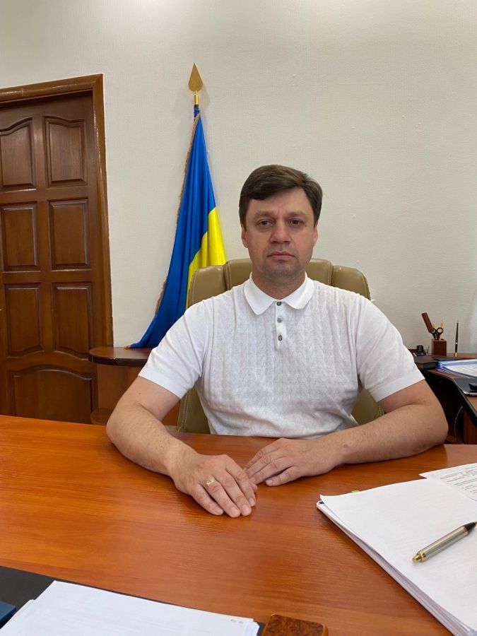
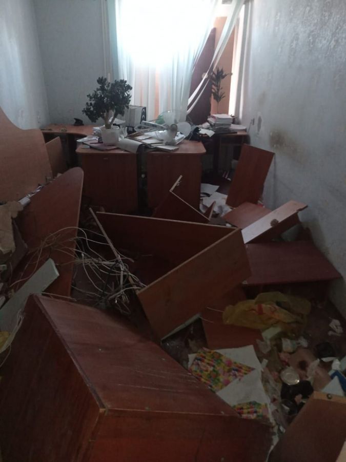
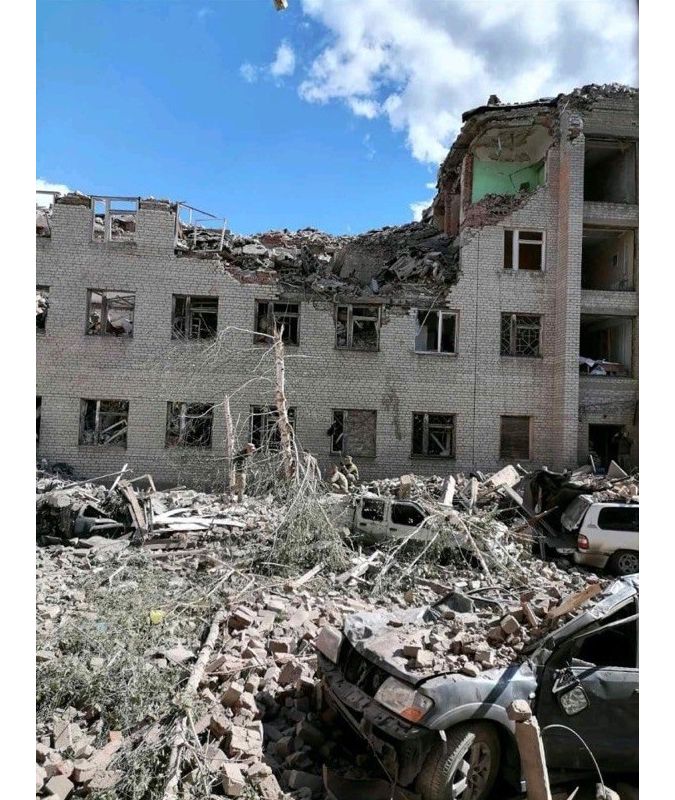
When asked about the challenges his organization faces today, Serhii Zavadskyi, head of the State Service of Ukraine for Geodesy, Cartography and Cadastre (StateGeoCadastre) in Kiev, stays admirably calm: “About 50 of our regional offices have been seized by the occupants and are totally unavailable at present. Eight of our premises are seriously affected as a result of the Russian Federation’s armed invasion. To ensure that the organization can continue to function, personnel from the regional offices that are under occupation have been or will be partially transferred to other regions or cities in Ukraine. We have made backups of our data so it is safe. We keep copies of all essential databases on different servers, with restricted access.”
StateGeoCadastre is a huge organization with around 10,000 employees and hundreds of points of contact in the regions. But then, Ukraine is a vast country; comprising more than 600,000km2, it ranks 46th in the world in terms of size. StateGeoCadastre is responsible for all the geodetic surveying and mapping of this area, as well as the cartographic registration of cadastral parcels and the title registration of land. The registration of property titles is done by another government agency, the State Register of Property Rights to Real Estate.
Lack of Staff
The 100% publicly financed institution still has some financial resources, but they are now more limited since the conflict means that the state’s funds are needed for other purposes. That is a source of great concern at StateGeoCadastre’s head office, although that is not what kept Serhii Zavadskyi awake at night at the beginning of the war. “One of the major worries was the lack of staff. Since the beginning of Russia’s invasion of Ukraine, 123 StateGeoCadastre employees have joined the armed forces, plus we are keeping a close eye on all our employees who remain in Ukrainian territory that has been seized by the aggressor. Fortunately, none of our staff have been physically injured, but everyone has clearly sustained some emotional and psychological damage,” he explains. “However, people have mobilized; even in the absence of proper resources, everyone is trying to protect the nation. When it comes to the defence of our state, there is a higher degree of understanding. Because of the elimination of bureaucratic barriers and our focus on the accomplishment of the ultimate aim – military victory – any critical process can be completed in a couple of hours. As a result, people are the most essential resource for StateGeoCadastre in all of its activities.”
Satellites
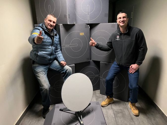
What also helps is Elon Musk’s satellite infrastructure: Starlink. SpaceX quickly responded to the Ukrainian government’s call on Twitter to help keep the internet working in war-struck Ukraine even when there are power outages. Today, more than 10,000 stations help connect and support critical energy and telecommunications facilities, healthcare and other facilities. StateGeoCadastre was given ten Starlink units throughout the country. Currently, internet quality from Starlink in eastern Ukraine is not as good as in the west because Ukraine does not have its own Starlink ground station. But any war, no matter how destructive, cannot last forever. The Ministry of Digital Transformation of Ukraine announced that “after the victory, together with Elon Musk, we plan to build our own Starlink ground station to improve the quality of satellite Internet for all Ukrainians.”
Still on the topic of satellites, StateGeoCadastre has not replaced aerial photography or ground-based surveying with satellite images, even in the current circumstances. Zavadskyi: “They are sometimes used as input for certain hybrid monitoring activities. But the images from space are not the answer to today’s challenges, whereas traditional surveying is often more suitable for updating basemaps in severely damaged urban areas and so on.” This does not mean that StateGeoCadastre is not interested in Earth observation and satellite positioning-based initiatives like EUSpace4Ukraine (see box) aimed at helping to tackle the humanitarian challenges in the country. StateGeoCadastre intends to make use of the platform if necessary, but so far that has not been the case according to Zavadskyi.
Be Prepared
When asked what advice he would give to comparable organizations elsewhere to ensure they are prepared for a war, Zavadskyi says: “Transferring data to cloud storage is the best option. Do something about the legal obstacles if they still exist. There should be a strategy in place for evacuating the database in the event, and the procedures should be regularly tested in real life.”
“Secondly, data is normally kept in two secure data centres: the primary and the backup, which must be located a significant distance apart from one another. It’s necessary to develop a high-quality geospatial data infrastructure and geoinformation tools, allowing users to deal with data in both secure and public modes. And thirdly, it’s important to devise an effective means to shield information from the enemy, and to reconsider the notion of making public data as open as possible for re-use,” he adds.
Data Breaches
So far, there has been no evidence of a data breach by the Russians in Ukraine; any cartographic resources have been given with the permission of the Ukrainian Armed Forces’ topographic service. However, all geospatial data owners and producers have been advised to stop publishing and disseminating geodata via geoportals in order to prevent database breaches. Zavadskyi observes: “The lack of unrestricted public access to information is what distinguishes the cadastre in conflict from the cadastre in peacetime. Everything is still in place in terms of developing and maintaining the registers. One of the most difficult issues following the war may be the demand for information such as up-to-date topography in the liberated regions. However, we have no way of yet comprehending how serious these issues will be for us and our fellow public administrations. And there are some things that you can’t prepare for. For instance, the Ukrainian global positioning system is partly functioning. Station disassembly is a serious issue everywhere. Most ground stations are operational; they work in collaboration with other commercial networks. But as for the stations that exist in the territories temporarily controlled by the Russians, we have no idea what has happened to them.”
Land Reform
Another huge challenge Ukraine has to tackle (with support of The World Bank and others) is that the country is in the midst of a land market reform, with StateGeoCadastre playing a leading part in the execution. Of Ukraine’s total land area of 60 million hectares, roughly 42 million is classified as agricultural land. 25% of all agricultural land is owned by the state. The rest was distributed in small parcels some 20 years ago among members of former communist collective farms. The owners either lease this land to large agricultural holdings or farm the land themselves, although there are about seven million small landowners in Ukraine. In 2021, laws were passed to open up the agricultural land market. To give ‘small’ farmers a head start, in the initial years a Ukrainian citizen can buy a maximum of 100 hectares (aided by cheap loans). From January 2024, this will increase to a maximum of 10,000 hectares for all Ukrainian citizens/legal entities. A referendum is set to decide whether foreigners should continue to be excluded. However, this reform project has been put on hold during the Russian military invasion.
“We were absolutely ready to launch the land market reform,” states the head of StateGeoCadastre firmly. Since the majority of the state land it is not currently properly marked in the cadastre, the organization had started to train regional land surveying engineers in the accurate demarcation and registration of cadastral plots. The introduction of automatic information exchange with the State Register of Titles has also been an important step. The same goes for the countrywide deployment of a geoportal, which delivers the essential information to notaries and other stakeholders.
Apart from supporting the land reform, the geoportal will contribute to making geospatial public data more accessible to the Ukrainian public and private sectors. It will be easier to disseminate the 1:50,000 scale digital topographic map and the topographic database about the Ukrainian territory. The organization was planning to follow these with maps at 1:10,000 and 1:25,000 scales, as well as procedures for real-time updates and the rollout of a geographical names system, and so on. There were also plans to launch remote sensing for tracking land usage and the evolution of natural resources. “After the war, the projects can immediately be resumed in full capacity,” he says resolutely.
Accelerate the Victory
Zavadskyi concludes the interview with a heartfelt statement: “The cruel war that the Russian Federation has been waging against us since 24 February has brought much sorrow and suffering. All StateGeoCadastre employees continue to work despite the full-scale invasion and are doing their best to accelerate our victory. That is now the focus of the Ukrainians, as well as on providing assistance to our armed forces, which are bravely defending Ukraine and keep risking their lives for our country every single day. I know that Ukraine is not alone in her endeavour to win and to rebuild everything that was inhumanely destroyed. These trying times have truly shown us the many international, real friends and of that I am very proud. After all, in the fight against evil, it is important to be united.”
Please go here to learn more on how the EUSpace4Ukraine platform focuses on satellite data-based applications that help NGOs in Ukraine to deliver medical and food supplies, support evacuation efforts, and also help refugees find their way in other EU countries.

Value staying current with geomatics?
Stay on the map with our expertly curated newsletters.
We provide educational insights, industry updates, and inspiring stories to help you learn, grow, and reach your full potential in your field. Don't miss out - subscribe today and ensure you're always informed, educated, and inspired.
Choose your newsletter(s)


