Challenges in Validating Large Spatial Datasets
Experiences Using Airborne Lidar Data
This article discusses the challenges involved in determining the accuracy of large spatial datasets, using airborne Lidar data as an example. Vendor and end-user blunders resulted in errors as high as two metres and as low as 1cm at different locations from the same dataset. To prevent such blunders, the ‘checkpatching’ method is proposed. Checkpatching detects errors in large spatial datasets using a sampling method employing randomly selected patches. Checkpatching also accounts for varying topography and ground cover. These potential error sources are overlooked by methods that simply use point elevations from ground surveys to check interpolated elevations at the same location.
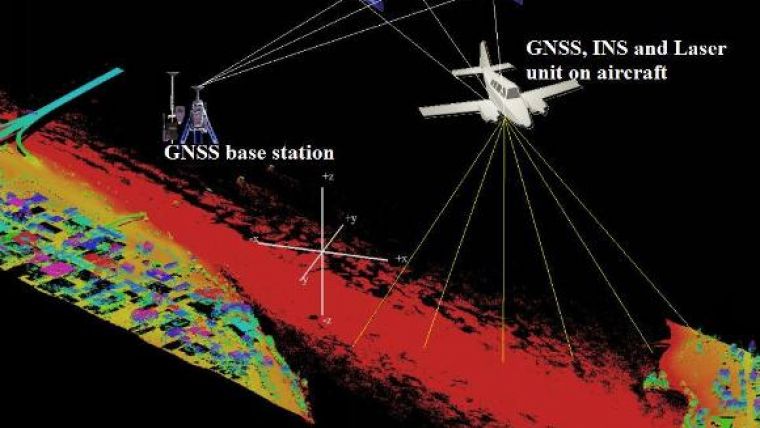
Historically, when employing conventional surveys, end users of surveyed data have confirmed the accuracy of a dataset by randomly checking the delivered final coordinates. Today, however, complex technology captures billions of points to provide instant spatial information. A good example is Lidar, which employs and integrates a laser range detection system, an inertial navigation system (INS) and GPS to capture spatial data as shown in Figure 1.
Error is a deviation of a measurement from the true value due to one or more causes. In this context, the term ‘true value’ refers to a measurement that is at least three times more precise than the subject measurement to be validated.
After the design of user specifications and the subsequent data delivery, two major possibilities of error in determining data quality were encountered: namely, problems with some parts of the acquired data (errors from the Lidar survey vendor who has the primary task of planning and performing the survey according to specifications) and problems with the field validation process (error from the client or end user who has the mandate to determine whether or not the data was delivered according to specifications). However, the total propagated error will usually include a combination of both the Lidar survey errors and the field validation survey errors. Encountering these problems led to questions concerning the implications of the errors in the creation of accurate spatial data products.
The Checkpatching Technique
Like any large dataset, it is practically impossible to validate each Lidar point in a project area by comparing it with a surveyed checkpoint. Therefore, sampling is necessary when validating large datasets produced from ALS surveys. With respect to empirical validation of the accuracy of large point clouds, a modification of the ‘patch validation process’ (used over the years by Merrett Survey Partnership UK) was employed. The patch validation method uses conventional land surveys in a defined test area to validate Lidar coordinates. When the test area is randomly chosen to cover varying terrain morphologies and ground cover, this article refers to it as a ‘patch’. Five separate patches were chosen (see Figure 2) to cover the main variations in topography within the test area. This intentionally deviates from the patch validation method employed by Merrett Surveys where only one patch is employed. This modified procedure is referred to as ‘checkpatching’.
Continue reading in the online edition of GIM International.

Value staying current with geomatics?
Stay on the map with our expertly curated newsletters.
We provide educational insights, industry updates, and inspiring stories to help you learn, grow, and reach your full potential in your field. Don't miss out - subscribe today and ensure you're always informed, educated, and inspired.
Choose your newsletter(s)


