Change in Tajikistan
A New Country in Need of New Data
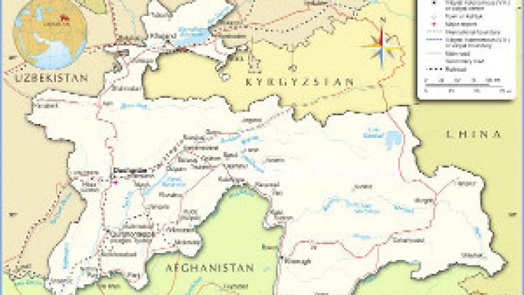
Tajikistan, officially Jumhurii Tojikiston, is a mountainous country in central Asia bordering in the south on Afghanistan, to the west on Uzbekistan, and to the north Kyrgyzstan. On its eastern border lies the People’s Republic of China. Tajikistan is also adjacent to Chitral and the Gilgit-Baltistan region in Pakistan, separated from them only by the narrow Afghan Wakhan corridor (Figure 1). The country once belonged to the former Soviet Union, and since becoming independent in 1991 the lack of a unified mapping system or national coordinate system has presented a major obstruction to national development.
During the Soviet occupation a national coordinate system was established and maintained by the military authorities; the coordinates were thus highly classified and unavailable for civilian purposes. Some local civilian coordinate systems were deliberately misleading to prevent enemy missiles reaching their targets. In order to establish a national coordinate system and a comprehensive new national administration system and database structure capable of handling old existing and newly gathered data, Tajikistan joined forces with Sweden. The Swedish Lantmäteriet (National Mapping, Cadastral and Land Registration Authority of Sweden) acted as executing party.
New Coordinates
Managed by Bo Göran Holmgren of Lantmäteriets, the project got underway in 2005 with transformation of the existing military coordinate system into a national system for civilian use. Between 2005 and 2007 new coordinates were calculated, using GNSS equipment, at six formerly military locations spread across the country. One of the reference stations is located in Dushanbe, the capital of Tajikistan, and broadcasts correction signals all over the country using UHF radio frequencies for real-time surveying purposes. The distances involved limit the accuracy of this information, but these GNSS stations formed the beginnings of a new national coordinate system and will serve as basis for all future activities pertaining to
land administration.
Complex Layers
Field surveys were executed using GNSS equipment with correction signals coming from the reference station in Dushanbe in real-time mode, and information from the other stations in post-processing mode. Post-processing was done with Topocad software, a Swedish system that enables the user to create individual layers for specific data. The layering structure in Topocad became very complex during this project, as there was so much interesting data. Some layers contain scanned older Soviet maps based on aerial photographs showing, for instance, collective farms and irrigation systems. These were taken out of production in the ’80s and not updated since, but they still function as reference, with a precision of around five metres. Old maps and orthophotos from Soviet times are not especially important, except as an interesting historical source that shows what the country once looked liked. Existing orthophotos and satellite images were also used as reference.
The more specific the data became, the more layers were created. Layers are originated at an increasing pace, containing information about urban constructions, borders, roads, communication and the like. Such a large volume of data could clutter the layer structure and make it difficult to handle, but the Topocad software kept layer information and structure well organised.
Local Operation
An important aspect of the Tajikistan project is communication with local authorities and training of Tadjikian technicians in surveying, operating GNSS systems and using the Topocad software system in the Russian language, complete with keyboard employing the Cyrillic alphabet (Figure 2). Majib Obaid was the man involved here, a GIS expert and programmer who moved from Afghanistan to Sweden, where he studied computer science. He became an important link in the cultural interaction between Sweden and Tajikistan, speaking as he does Farsi with the local population, and Swedish and English too.
Transparency
This database will drastically change the standard procedures for all kinds of allocations and permissions needed for urban construction, previously all done by talking and signing documents. It was a process that got going only after a few dollar notes had been slipped between the documents. In this digital and transparent system, slipping a dollar note into the keyboard will not affect the system; allocations are not controlled by a single individual, and all activities can be traced back to source. This implies that Tajikistanis now have a secure and rational way of working with urban constructions. They have a cadastral map (Figure 3) similar to the Swedish one, with all necessary information, data concerning size of area, district name, building registration number, signature etc. The new national coordinate system and database for urban construction will facilitate development of infrastructure, road and house building. Land-usage planning is also made easier, which benefits the entire country.

Value staying current with geomatics?
Stay on the map with our expertly curated newsletters.
We provide educational insights, industry updates, and inspiring stories to help you learn, grow, and reach your full potential in your field. Don't miss out - subscribe today and ensure you're always informed, educated, and inspired.
Choose your newsletter(s)


