Changed Perspectives in Land and Water Management
Situated in the delta of the rivers Meuse and Rhine, the Netherlands have a long tradition in land and water management. The fertile soils along the rivers and coast were quickly occupied for food production, the waterbodies were used for transportation of people and goods, and along this transportation network settlements emerged. However, the proximity to water bodies also meant the risk of flooding. Since the very first beginning, the main aim was to reduce the risk of flooding by embanking the rivers. Dams and locks were constructed as well to keep water levels high enough for – cross border – traffic on the rivers further inland.
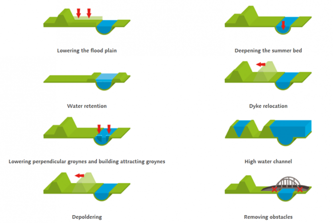
Along with these measures, the natural course of the rivers and their meandering nature were constrained into a static riverbed. Since in 1995 and 1996 extremely high discharge levels in the main river systems almost led to the breakthrough of dikes, which would cause large areas to be flooded, the perspective on water management changed. Instead of heightening dikes over and over again, the new perspective introduced the idea to give more space to the river. By widening the riverbed and reintroducing natural dynamics within this broader river system, the risk of flooding was reduced while meanwhile the environmental value increased. A special planning programme – called ‘Room for the river’ - with 30 different projects was established to materialize this idea (see Figure 1). The iconic ‘spatial plan Stork’ (H+N+S, 1986) introduced this new perspective for the flood plains along the river Waal.
A similar changing perspective can be seen regarding water management in rural areas. Initially, in favour of agriculture drainage systems were constructed and groundwater tables were kept low in wetter areas. Such interventions extended the period within which the land is workable with machines or accessible for cattle. However, nowadays the drawback of this water management strategy becomes more and more visible. Permanent lowering groundwater tables, led to loss of biodiversity, soil degradation and subsidence in peatland areas. Add up to this, longer spells of drought in combination with torrential rains especially in summer, and the need to re-think the strategy in rural areas for water management becomes clear. Nowadays a more comprehensive view on water management is taken, to accommodate all land use types in rural areas. Groundwater table should suit both agriculture and nature conservation areas. In addition to general measures to keep water for a longer period in the area such as re-meandering of local streams, natural banks or temporary ponds, various local measures are taken to manage water at the micro level such as local dams operated by the landowner itself. At the same time we constructed parallel water streams, for a higher capacity of the rivers when discharge is high. Guiding principle is to take a coherent set of measures at watershed level.
Hosted in the Netherlands, the FIG Working Week was supposed to give you a good overview of land and water management practices in this country. In addition to the technical program, several social activities, social and technical tours were scheduled to highlight Dutch experiences. Now you must miss all this, as an alternative, we will focus in this article on Dutch practice in land and water management. More content regarding international contributions to spatial planning, including land and water management, can be found in the commission 8 article.
Geo-information and the Environment and Planning Act
Over time, the legislative framework for environment and spatial planning turned into a complex system of over 40 laws, 120 general administrative orders and hundreds of regulations. To deal with this overload of regulations cost a lot of effort and is time-consuming.
To simplify and align all legislation in the domain, the Environment and Planning Act (Omgevingswet) will merge existing laws into one single Act. The new Act, which should become effective as of 2021, aims to increase efficiency for involved agencies and transparency for all stakeholders. Key to the latter, is the introduction of a coherent digital system for administrative and geographical information. From a planners’ perspective two principles are leading: (1) single data collection, multiple use, and (2) all stakeholders must have access to this information so that parties are equally informed.
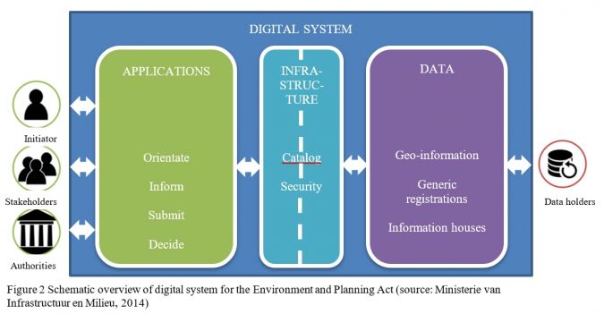
The ‘Omgevingswet’ as we call this in the Netherlands combines legal rules, business rules and geometry in a system of software components and services. These concepts are used to provide end-users – citizens and companies – answers to the question if they need a permit from the government for their activities with impact on the environment (e.g. new infrastructure, expand buildings, draining waste water). Specifically, this means that the users (government, citizen and company) through a one-stop permit application, can request and see which rules and policies apply to a location. So, with one click on the map one can see whether intended activities are allowed.
Transparency, coherence and rapid decision-making are important concepts in the Environment and Planning Act. The digital aspects are important preconditions for the proper functioning of this. The Environment and Planning Act contains the obligation that all decisions for the physical living environment are digitally available and linked to so-called location data. Standardization provides better information, but the (administrative) work processes are sometimes still from the old days and do not yet use or register geographical coordinates: A challenge for many public organizations.
The Environment and Planning Act will need facts to come to a decision. To ask questions and gather answers the system needs input (facts) such as a location with the intended activities defined by the Environment and Planning Act. The location can either be an address, a point on a map or even a polygon. The ambition is to tailor information as much as possible by using standard geo-coordinates and, where possible, to ensure digital communication with the government. This has an impact on the geo-information. It must be timely, reliable and complete. This can give people working on geo departments a boost to be top-of-mind again in their organizations.
Necessity of high-quality Geodata
During the last decades the Dutch government and geo-sector put quite some effort in the availability of geodata. During the ongoing demands, particularly for high-quality data, which are essential for making informed decisions, we introduced a digital dissemination platform called ‘PDOK’ (Publieke Dienstverlening Op de Kaart) which refers to Public Services on Mapping (https://www.pdok.nl/), which proved to be an enormous support in all our spatial planning projects. Apart from the fact that it’s all Open Data (free available information), we also managed to bring the most valuable datasets (Basemaps, etc.) easily available and accessible on this platform. This platform offers a great source of all kinds of geodata, and is accessible and available for all kind of business: it’s free of charge for use in land surveying-companies, engineering bureaus, rural planning and even for use at civilian purposes.
Developing, maintenance and improvement of this collection of geodata is still on-going: nowadays we have a program (SOR; Coherent Object Registration), in which the aim is to unify and standardize all basemaps and key-registrations, so that the use of this collection can even broaden. Therefore, all major companies and governmental organizations provide the DiS-Geo project (work together in collaboration for geo) with their knowledge.
The substantive and technical further development that requires this, will yield greater social returns and can be realized more efficiently if this is done in conjunction. An important development with which DiS Geo has started is the development of a coherent object registration. A coherent object registration is one central organized uniform registration containing basic information about objects in physical reality. By this, we mean visible objects in the terrain, such as buildings, roads, water, railways and trees, parts of the terrain, supplemented with some (administrative) objects such as residences, municipal borders and public spaces. The basemap registrations are developed independently of each other, and therefore do not yet form a coherent entity. This hampers synergy in control, funding, collection, quality management, and use, and the associated cost advantages. Once coherent it will make the use of the geo component for e.g. the ‘Omgevingswet’ easier.
There has been quite some papers about land and water management. Unfortunately, there is no opportunity to share this live during our Working Week in Amsterdam. If you are interested in reading more about land and water management, we refer to this website.
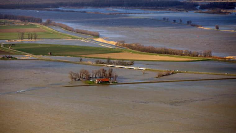
Case ‘Noordwaard’
For centuries the Netherlands has fought against the water. It was so successful that the Dutch people did not only protect themselves from the water, but actually reclaimed considerable areas of excellent arable land from the 1200s onward. It was the time that farmers started to build dikes stay save from sea and river water and constructed mounds (NL: 'terpen'), save havens for dwellings, farms and churches. The struggle is ongoing until with the same vigorousness until recently.
When engineers realized that they were losing grip on the situation, they changed the strategy some 10 years ago. Main reason: climate change! Dykes were no longer strong and high enough to protect land against increasing river discharge as a result of more (intense) rainfall and higher sea water levels because of melting ice from the arctic and mountain glaciers.
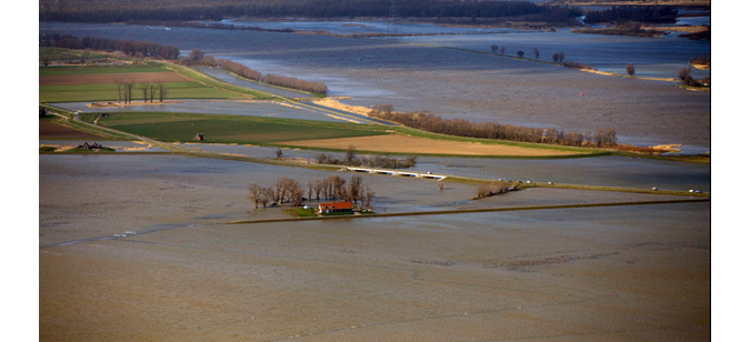
Geo-engineers developed a new strategy: Live with the water instead of fighting against. One of the flagship projects of the ‘Room for the River’ programme was de “Noordwaard”, referring to a large polder in the west of the Netherlands. Instead of higher dikes, dikes were lowered, so that the water could flow into the polder thus lowering high water levels in the downstream industrial area of Rotterdam. Land reallotment, combining with infrastructural work (parallel stream beds, farms on earthen mounts, roads free from flooding, etc.). The land base registers, the cadastral map and detailed digital terrain model were needed to make sure that the final result worked according to the requirements: keeping the farmers save during high water, while respecting ownership and land use rights.
Next to improving conditions for cattle raising, also functions like nature and recreation were reinforced. Large areas of wetlands were created and a network of bike lanes were laid out. The Noordwaard is now a showcase for how the new integrated land and water strategy can be implemented.

Value staying current with geomatics?
Stay on the map with our expertly curated newsletters.
We provide educational insights, industry updates, and inspiring stories to help you learn, grow, and reach your full potential in your field. Don't miss out - subscribe today and ensure you're always informed, educated, and inspired.
Choose your newsletter(s)


