Characterizing activities in 3D city modelling
The quest for the big picture
As 3D models are becoming common geospatial data assets for cities around the world, a recent study reviewed major 3D city modelling activities in Finland. 3D city models can be utilized for tasks including planning, visualization and decision-making. The field of 3D city modelling is diverse, with a multitude of technical solutions. Even the definition of what constitutes a 3D city model still remains ambiguous. Yet, surprisingly few studies have focused on reviewing the existing activities and assembling the big picture. This article presents some of the key findings from the study in Finland.
3D city models can be seen as an enabler in the smart city paradigm, operating as a user interface to the modern urban environment and acting as a platform for cooperation and services. Therefore, a high degree of interoperability is expected from city models and from the information systems that host them. Also, 3D city models are expected to support a multitude of applications. This remains a challenging task, still hindered by many issues, such as ambiguities and differences in modelling, differences in perspectives, missing guidelines, challenges in data conversion and georeferencing, and problems in data quality.
Quest for data integration
Data integration is an inherent component in city modelling. 3D city models are commonly built through 3D reconstruction and data integration, by merging photogrammetry or laser scanning data with GIS data such as building footprints and IDs. Also, the use of highly detailed building information models (BIM) as a source of as-planned data remains a significant development topic. Another development direction is the integration of time series and sensor data to the objects in a city model. Rather than being static representations of the environment, inclusion of live data is turning city models into increasingly dynamic artefacts and towards the concept of a ‘digital twin’ of the city.
Expanding field of applications
The application space of 3D city models has expanded hand in hand with the technical development. In addition to the ‘traditional’ use cases in urban planning and zoning, 3D city models are expected to facilitate energy analysis, detailed architectural visualization, interactive and immersive applications development, and participatory GIS. All this places challenging requirements on the platforms of the 3D city models.
The discussion on 3D city models is further complicated by the amount of different platforms used for 3D city model applications. In addition to the professional GIS/CAD tools, 3D city models are used on game engines and various web-based 3D viewers, such as virtual globes.
Reviewing the major 3D city modelling projects in Finland
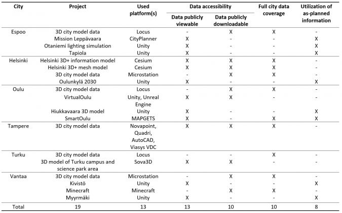
In a recent study, the authors took a closer look at some of the 3D city modelling projects in the six largest cities in Finland, using project descriptions maintained by the cities to obtain an overview of the current activities. To support further understanding, local city representatives in the studied cities were interviewed. A summary of the analysed projects is presented in Table 1.
Excess of platforms
Firstly, the studied 3D city models utilized a great variety of platforms. In the 19 studied projects, a total of 13 different platforms were discovered for hosting the models. These included GIS/CAD software (e.g. Trimble Locus and Bentley Microstation), virtual globes (e.g. Cesium, CityPlanner, Sova3D, MAPGETS) and game engines (e.g. Unity, Unreal Engine). Some of the software solutions applied in Finland were more or less unique and have not seen wide adoption globally.
Secondly, the authors noted that in each studied city the maintenance and upkeep of the 3D city models was tied to the statutory base mapping process that heavily relies on the chosen GIS/CAD software. In many cases, the 3D model data maintained by the city itself was used as an input or reference data for virtual globes and 3D game engine-based projects, which focused on specific applications often aimed at broader audiences.
Data quality and accessibility
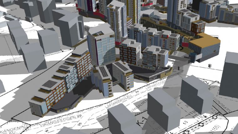
The studied 3D city modelling projects contained a variety of different levels of detail, ranging from simple block models to highly photorealistic models containing facades modelled in great detail. Fewer than half of the models utilized as-planned information such as BIM or architectural plans. More than half of the city models covered the full regional area of the city.
In addition to data quality, accessibility plays a vital role in 3D city modelling, especially when models are to be used as a basis for developing new applications. Almost two-thirds of the studied city models could be freely viewed via a web-based viewer. This was realized either via separate viewer utility or, in the case of virtual globes, natively by the platform itself. More than half of the city models studied were offered for download over the internet. However, none of the cities offered any original raw data such as Lidar point clouds. This hinders possibilities to freely edit the models or to run additional analysis.
The ideal of a general model
Producing and maintaining a 3D city model requires an interplay of several technical solutions and stakeholders, both of which vary from project to project. Many of the studied cases were likely to serve only a limited number of purposes or to pilot 3D modelling in a limited area. However, the interviews showed that this had not been the original intention in the cities. On the contrary, the common vision was close to the ideal of 3D city models serving as general platforms, including the capability to re-use the gathered data and models.
Further, an increased degree of realism in visualizations, attained with 3D models, was seen as a key element in enhancing the interaction and trust between different stakeholders. This includes the notion of demonstrating impact as well as including all relevant stakeholders in the co-design and decision-making processes.
Stakeholders inside and outside city organizations are a heterogeneous group of users that have varying needs, expectations and views of 3D city modelling. The city interviewees stated that up-to-date guidelines and policies were missing or that the existing guidelines were not followed. Ambiguous terminology, lack of coordination and leadership, and the slow adaptation of standards frequently crippled communication and collaboration. Additionally, the lack of expertise was said to result in an incapacity to recognize the need for 3D city modelling and hence to define the requirements for the modelling projects.
Understanding the big picture
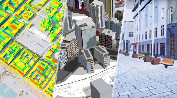
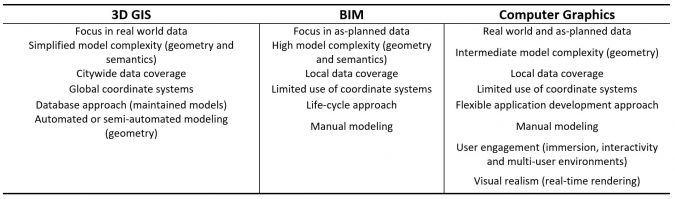
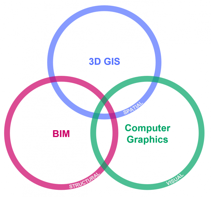
By looking at the characteristics of the studied 3D city modelling projects and literature, it was possible to identify three partially overlapping operational cultures in the 3D city modelling scene: 3D GIS, BIM, and computer graphics. Each of these operational cultures (Figure 2) has a unique perspective on 3D city modelling and they often lead to differing realizations (Table 2).
In the 3D GIS category, the modelling projects typically have a large regional coverage but a limited level of detail in 3D reconstruction. Further, the role of semantic data and connection to the existing city GIS data is emphasized over mere geometric reconstruction. Most of the applications focus on professional uses like city planning, mapping and various geospatial analysis. Projects in the BIM category focus on integrating as-planned data from individual buildings to models of limited regions. Understandably, aspects like model conversion and inclusion of interiors are pronounced. Typical applications in this category include urban planning, building permit processes and architectural visualization. The projects in the computer graphics category are based on game engines, offering the highest level of photorealism facilitated by advanced real-time rendering. At the same time, models are typically limited to local coordinate systems and they rarely utilize semantic information. Also, the 3D game engine-based models have a clear emphasis on game-like interaction and immersion, with the goal of engaging users to collaborate in and explore the models, even on a pedestrian level.
In the big picture, 3D city modelling is revealed to be a diverse and multidisciplinary field with steadily increasing interest and demand. It is often accompanied with visions of a high degree of interoperability and platform-like characteristics. However, when reviewing the modelling activities more closely, they appear fragmented and fail to reach the broad applicability envisioned.
This is, to some extent, explained by the complexity of the situation. Modelling projects are carried out by people from different fields, using varying tools and aiming for different outcomes. Further, the future uses for 3D city models can be hard to predict – and not only because the user group is heterogeneous with different levels and types of expertise. As an outcome, the quest for a single, completely harmonized 3D city model becomes demanding and laborious. Improving the interplay and communication between people and technologies across these three operational cultures is a key element in advancing the interoperability and creating flexible, demand-driven 3D city models of the future.
Further reading
Julin, A., Jaalama, K., Virtanen, J. P., Pouke, M., Ylipulli, J., Vaaja, M., Hyyppä, J., & Hyyppä, H. (2018). Characterizing 3D City Modeling Projects: Towards a Harmonized Interoperable System. ISPRS International Journal of Geo-Information, 7(2), 55. https://doi.org/10.3390/ijgi7020055

Value staying current with geomatics?
Stay on the map with our expertly curated newsletters.
We provide educational insights, industry updates, and inspiring stories to help you learn, grow, and reach your full potential in your field. Don't miss out - subscribe today and ensure you're always informed, educated, and inspired.
Choose your newsletter(s)


