Combining Hydrography and UAV Photogrammetry for Lake Volume Calculation
Creating a 3D Model for Volume Calculation with Boat and UAV
What is the best way to generate a high-precision 3D model to estimate the storage capacity of a lake that is surrounded by mountains? Rapid weather changes, low clouds and steep mountainsides demand a sensible approach with the right equipment. This article provides insights into the surveying process of a lake mapping project including the methods used to create a 3D model for the generation of a precise map with elevation lines.
(By Benjamin Federmann, Benjamin Busse and Kim Schlüter, Germany)
Situated at 848 metres above sea level in the Swiss Alps, created by an ancient rockslide and flanked by the 2,900m-high Glärnisch mountain massif (Figure 1), the Klöntalersee lake is a stunning attraction for tourists and artists alike due its ravishing beauty. But poets and painters are not the only ones to have recognised the potential of the 3.3km2 lake, which is fed by the surrounding mountain brooks like the Klön. In 1908 a dam was constructed on the eastern side of the Klöntalersee, between Rhodannberg and Sackberg, to generate electricity for homes and businesses in the surrounding area. Thanks to the bulk earth dam, which today is 220 metres long and 21.5 metres high, the lake can hold approximately 39.8 million cubic metres of water, which can be used to generate electricity during times of demand peaks or fluctuations.
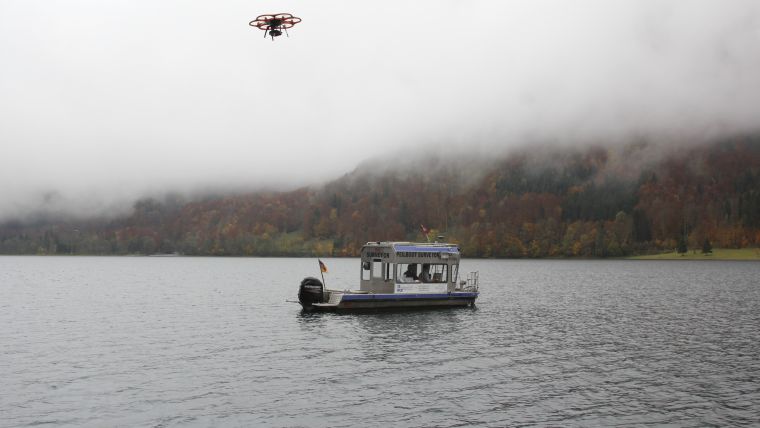
In an approach combining hydrography and photogrammetry, the IngenieurTeam GEO crew planned to survey the area using their sounding boat Surveyor, the industrial unmanned aerial vehicle (UAV) Aibot X6 (Figure 2) as well as positioning technology from Leica Geosystems to generate a 3D model for accurate and centimetre-precision calculation and simulation of the actual holding capacity.
Multibeam echosounder
After all the preparatory measures, approval processes and planning steps had been completed, the experts travelled with their sonar-equipped vessel Surveyor to the Klöntalersee to map the lake’s soiling situation at a regular water gauge. With 172 planned recording lines, the six-metre-long vessel set sail to create a detailed picture of the lake’s soil using its Teledyne Reson SeaBat 8101 multibeam echosounder. The fathometer emits acoustic signals at an angle of 150 degrees and calculates the depth of the water by measuring the elapsed time of the echo. With 101 beams per ping at a frequency of 30 pings per second, the hydrographs receive high-precision data of the bed with a graticule of 3,030 single points per second. With an overlap of one third of every measuring track, the experts achieved an accuracy of better than ten centimetres during their measurements. But before gathering the data, the measuring system had to be calibrated precisely in order to avoid disturbance factors and to correctly determine the results.
Adjusting the sensors
That entailed adjusting the sensor technology before every deployment to subtract both linear movements of the vessel as well as rotation around its axles to impede any errors. A further step for the hydrographers to obtain a clear and detailed view of the lake bottom was to factor the water’s sound velocity into the calculation. The sound velocity changes depending on temperature and suspended particles and becomes especially important in lentic water.
After the boat had been launched and calibrated, the crew put out to sea on a 2.5-hour initial cruise to get a first impression of the lake’s character and began to create the first sonar data of the soil. Following their planned routes and taking the lake’s depth and texture into account, the hydrographers on the Surveyor collected enough information to create a point cloud containing almost 135 million XYZ coordinates. All in all, the crew on the observation boat succeeded in recording all 2,855,204 square metres of the Klöntalersee in just five days.
Not only rapidly changing weather conditions and bone-chilling cold pushed man and machine to their limits, but the glaciated Glärnisch massif forming the lake’s southern shore quite literally cast a 2,900-metre shadow and put the technology to the test. With the massif’s steep slopes in such close proximity to the water’s edge, the experts feared they might lose their GPS stream due to signal opacity on the south side of the Klöntalersee. In that case, tachymeters placed on the northern and eastern shores of the lake would have determined the boat’s position. However, because of the lake’s elongated kidney-like shape, that would have caused serious problems in obtaining accurate details about the boat’s position.
Steady positioning
By using the Leica Viva GS 16 GNSS antenna on the Surveyor the data recorded with the multibeam sonar could be assigned to the coordinates with centimetre precision. Thanks to the built-in SmartLink technology, the crew would still have been able to record high-precision data and receive GNSS correction data even if the GSM network signal would have been lost. Thanks to 550 channels, a state-of-the-art surveying engine and ultra-modern RTK algorithms, the data from both the Aibot X6 UAV and the vessel could be precisely assigned with the test results.
Airborne surveying of the shores
Shore situations are hard to capture for multibeam-equipped vessels due to their general design. In addition to that, the risk of damaging the sensitive and expensive sensor rapidly rises in shallow water and in proximity to the shore. In order to obtain exact results for the volume calculations and simulations in spite of this, the engineers drew on their experience with the UAV and decided to capture the shores and embankments via airborne photogrammetry.
After the lake was measured at regular water level from the boat, the engineers began to plan the flights of the UAV. To capture the shore regions overlapping with the measurements taken by the boat, it was crucial to fly the UAV at lower water levels. Once the level of the Klöntalersee had lowered seasonally, the survey with the hexacopter could begin.
To record the often angled and steep terrain of the bank area as precisely as possible, the experts decided to survey each area several times to increase the validity of their data. After the flight planning on the PC had been completed and the waypoints had been loaded onto the UAV’s internal storage device, the ground control points (GCPs) around the lake were captured using the GNSS receiver so the first flights could begin.
Challenging conditions
Once again, the surveying of the alpine reservoir presented its very own challenges for man and machine. In addition to average below-freezing temperatures, rapid weather changes and low clouds, the southern bank of the Klöntalersee with its steeply sloping mountain walls once again posed the biggest challenge. The UAV had to take off from and land on a separate boat because the steep walls and the dense vegetation along the shoreline made it impossible for the pilot to operate from the land. In addition to the sensitive and reliable technology, the pilot’s skills and steady hand were particularly important.
Despite the adverse conditions, the team from Karlsruhe was able to collect highly precise data in 18 flights, so the dry shore strip with a total length of over 12 kilometres was covered within two days. With a picture taken every two seconds and the drone moving with 4m/s, the experts ensured that the data was recorded with the highest accuracy by the camera attached to the flying multisensor platform.
As with the recordings of the surveying boat, it was of the utmost importance for the UAV-based results to be accurately referenced. For this purpose, the Ingenieurteam GEO experts used the Aibot HP GNSS 2 RTK/GNSS module (L1/L2) and the Leica GNSS receiver. This proved to be a good combination for working under such difficult conditions to achieve an accuracy of 1-3cm in georeferencing the collected data.
Post-processing the data
After all the measurements had been performed, the surveying experts began to process the obtained data. The point clouds created by the multibeam sonar had to be fed into the PDS 2000 bearing software to manually edit and correct them for errors. In order to integrate the shoreline data into the volume calculation, all 4,400 high-resolution images from the UAV had to be imported into Aibotix AiProFlight where they were merged with the coordinates from the UAV’s log file. After that, the georeferenced data was edited in the AgiSoft PhotoScan Pro post-processing software to create a three-dimensional model as well as a point cloud. Subsequently, the two 3D models were combined in the Autodesk application AutoCAD Civil 3D to generate an exact model of the lake (Figure 3).
Reliable 3D models
Using the data from the 3D model, the engineers generated a precise map with elevation lines for their client. The engineers stepped up to the plate and found the right tools to get the job done, combining two completely different ways of surveying large and challenging areas to generate precise results. With the data generated by the boat and the UAV, the experts were able to meet their client’s needs, whether they wanted a detailed virtual 3D model or a printed plan including contour lines.
Biographies of the authors
Benjamin Federmann studied business economics in Stuttgart and has been director of marketing, communications & product management at the German drone manufacturer Aibotix GmbH since 2015.
Benjamin Busse is a UAV pilot and expert in cartography and geomatics at the Karlsruhe-based Ingenieur Team GEO engineering office.
Kim Schlüter, who is studying politics and has written articles for German public-service broadcasting, joined Aibotix GmbH in 2016.

Value staying current with geomatics?
Stay on the map with our expertly curated newsletters.
We provide educational insights, industry updates, and inspiring stories to help you learn, grow, and reach your full potential in your field. Don't miss out - subscribe today and ensure you're always informed, educated, and inspired.
Choose your newsletter(s)


